
Edinburgh is the capital city of Scotland and one of its 32 council areas. Historically part of the county of Midlothian (interchangeably Edinburghshire before 1921), it is located in Lothian on the southern shore of the Firth of Forth. Edinburgh is Scotland’s second-most populous city and the seventh-most populous city in the United Kingdom.
Recognised as the capital of Scotland since at least the 15th century, Edinburgh is the seat of the Scottish Government, the Scottish Parliament and the highest courts in Scotland. The city’s Palace of Holyroodhouse is the official residence of the monarch in Scotland. The city has long been a centre of education, particularly in the fields of medicine, Scots law, literature, philosophy, the sciences and engineering. It is the second-largest financial centre in the United Kingdom, and the city’s historical and cultural attractions have made it the UK’s second-most visited tourist destination attracting 4.9 million visits, including 2.4 million from overseas in 2018.
Edinburgh’s official population estimates are 488,050 (mid-2016) for the Edinburgh locality, 518,500 (mid-2019) for the City of Edinburgh council area, and 1,339,380 (2014) for the wider city region. Edinburgh lies at the heart of the Edinburgh and South East Scotland city region comprising East Lothian, Edinburgh, Fife, Midlothian, Scottish Borders and West Lothian.
The city is the annual venue of the General Assembly of the Church of Scotland. It is home to national cultural institutions such as the National Museum of Scotland, the National Library of Scotland and the Scottish National Gallery. The University of Edinburgh, founded in 1582 and now one of three in the city, is placed 16th in the QS World University Rankings for 2022. The city is also known for the Edinburgh International Festival and the Fringe, the latter being the world’s largest annual international arts festival. Historic sites in Edinburgh include Edinburgh Castle, the Palace of Holyroodhouse, the churches of St. Giles, Greyfriars and the Canongate, and the extensive Georgian New Town built in the 18th/19th centuries. Edinburgh’s Old Town and New Town together are listed as a UNESCO World Heritage site, which has been managed by Edinburgh World Heritage since 1999.
Etymology
Edin, the root of the city’s name, derives from Eidyn, the name for this region in Cumbric, the Brittonic Celtic language formerly spoken there. The name’s meaning is unknown. The district of Eidyn centred on the stronghold Din Eidyn, the dun or hillfort of Eidyn. This stronghold is believed to have been located at Castle Rock, now the site of Edinburgh Castle. Eidyn was conquered by the Angles of Bernicia in the 7th century and later occupied by the Scots in the 10th century. As the language shifted to Northumbrian Old English, which evolved into Scots, the Brittonic din in Din Eidyn was replaced by burh, producing Edinburgh. Similarly, din became dùn in Scottish Gaelic, producing Dùn Èideann.
Nicknames
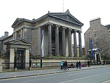
Surgeons’ Hall, one of the Greek Revival buildings that earned Edinburgh the nickname “Athens of the North”
The city is affectionately nicknamed Auld Reekie, Scots for Old Smoky, for the views from the country of the smoke-covered Old Town. A remark on a poem in an 1800 collection of the poems of Allan Ramsay said, “Auld Reeky. A name the country people give Edinburgh from the cloud of smoke or reek that is always impending over it.”
Thomas Carlyle said, “Smoke cloud hangs over old Edinburgh,—for, ever since Aeneas Silvius’s time and earlier, the people have the art, very strange to Aeneas, of burning a certain sort of black stones, and Edinburgh with its chimneys is called ‘Auld Reekie’ by the country people.”
A character in Walter Scott’s The Abbot says “… yonder stands Auld Reekie—you may see the smoke hover over her at twenty miles’ distance.”
Robert Chambers who said that the sobriquet could not be traced before the reign of Charles II attributed the name to a Fife laird, Durham of Largo, who regulated the bedtime of his children by the smoke rising above Edinburgh from the fires of the tenements. “It’s time now bairns, to tak’ the beuks, and gang to our beds, for yonder’s Auld Reekie, I see, putting on her nicht -cap!”
Edinburgh has been popularly called the Athens of the North from the early 19th century. References to Athens, such as Athens of Britain and Modern Athens, had been made as early as the 1760s. The similarities were seen to be topographical but also intellectual. Edinburgh’s Castle Rock reminded returning grand tourists of the Athenian Acropolis, as did aspects of the neoclassical architecture and layout of New Town. Both cities had flatter, fertile agricultural land sloping down to a port several miles away (respectively Leith and Piraeus). Intellectually, the Scottish Enlightenment with its humanist and rationalist outlook was influenced by Ancient Greek philosophy. In 1822, artist Hugh William Williams organized an exhibition that showed his paintings of Athens alongside views of Edinburgh, and the idea of a direct parallel between both cities quickly caught the popular imagination. When plans were drawn up in the early 19th century to architecturally develop Calton Hill, the design of the National Monument directly copied Athens’ Parthenon. Tom Stoppard’s character Archie, of Jumpers, said, perhaps playing on Reykjavík meaning “smoky bay”, that the “Reykjavík of the South” would be more appropriate.
The city has also been known by several Latin names such as Edinburgum while the adjectival forms Edinburgensis and Edinensis are used in educational and scientific contexts.
Edina is a late 18th century poetical form used by the Scots poets Robert Fergusson and Robert Burns. “Embra” or “Embro” are colloquialisms from the same time, as in Robert Garioch’s Embro to the Ploy.
Ben Jonson described it as “Britaine’s other eye”, and Sir Walter Scott referred to it as “yon Empress of the North”. Robert Louis Stevenson, also a son of the city, wrote that Edinburgh “is what Paris ought to be.”
History
Early history

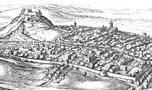
Edinburgh, showing Arthur’s Seat, one of the earliest known sites of human habitation in the area
The earliest known human habitation in the Edinburgh area was at Cramond, where evidence was found of a Mesolithic camp site dated to c. 8500 BC. Traces of later Bronze Age and Iron Age settlements have been found on Castle Rock, Arthur’s Seat, Craiglockhart Hill and the Pentland Hills.
When the Romans arrived in Lothian at the end of the 1st century AD, they found a Brittonic Celtic tribe whose name they recorded as the Votadini. The Votadini transitioned into the Gododdin kingdom in the Early Middle Ages, with Eidyn serving as one of the kingdom’s districts. During this period, the Castle Rock site, thought to have been the stronghold of Din Eidyn, emerged as the kingdom’s major centre. The medieval poem Y Gododdin describes a war band from across the Brittonic world who gathered in Eidyn before a fateful raid; this may describe a historical event around AD 600.
In 638, the Gododdin stronghold was besieged by forces loyal to King Oswald of Northumbria, and around this time control of Lothian passed to the Angles. Their influence continued for the next three centuries until around 950, when, during the reign of Indulf, son of Constantine II, the “burh” (fortress), named in the 10th-century Pictish Chronicle as oppidum Eden, was abandoned to the Scots. It thenceforth remained under their jurisdiction.
The royal burgh was founded by King David I in the early 12th century on land belonging to the Crown, though the date of its charter is unknown. The first documentary evidence of the medieval burgh is a royal charter, c. 1124–1127, by King David I granting a toft in burgo meo de Edenesburg to the Priory of Dunfermline. In the middle of the 14th century, the French chronicler Jean Froissart described it as the capital of Scotland (c. 1365), and James III (1451–88) referred to it in the 15th century as “the principal burgh of our kingdom”. Despite the destruction caused by an English assault in 1544, the town slowly recovered, and was at the centre of events in the 16th-century Scottish Reformation and 17th-century Wars of the Covenant.
17th century
Edinburgh in the 17th century
In 1603, King James VI of Scotland succeeded to the English throne, uniting the crowns of Scotland and England in a personal union known as the Union of the Crowns, though Scotland remained, in all other respects, a separate kingdom. In 1638, King Charles I’s attempt to introduce Anglican church forms in Scotland encountered stiff Presbyterian opposition culminating in the conflicts of the Wars of the Three Kingdoms. Subsequent Scottish support for Charles Stuart’s restoration to the throne of England resulted in Edinburgh’s occupation by Oliver Cromwell’s Commonwealth of England forces – the New Model Army – in 1650.
In the 17th century, Edinburgh’s boundaries were still defined by the city’s defensive town walls. As a result, the city’s growing population was accommodated by increasing the height of the houses. Buildings of 11 storeys or more were common, and have been described as forerunners of the modern-day skyscraper. Most of these old structures were replaced by the predominantly Victorian buildings seen in today’s Old Town. In 1611 an act of parliament created the High Constables of Edinburgh to keep order in the city, thought to be the oldest statutory police force in the world.
18th century

A painting showing Edinburgh characters (based on John Kay’s caricatures) behind St Giles’ Cathedral in the late 18th century
Following the Treaty of Union in 1706, the Parliaments of England and Scotland passed Acts of Union in 1706 and 1707 respectively, uniting the two kingdoms in the Kingdom of Great Britain effective from 1 May 1707. As a consequence, the Parliament of Scotland merged with the Parliament of England to form the Parliament of Great Britain, which sat at Westminster in London. The Union was opposed by many Scots, resulting in riots in the city.
By the first half of the 18th century, Edinburgh was described as one of Europe’s most densely populated, overcrowded and unsanitary towns. Visitors were struck by the fact that the various social classes shared the same urban space, even inhabiting the same tenement buildings; although here a form of social segregation did prevail, whereby shopkeepers and tradesmen tended to occupy the cheaper-to-rent cellars and garrets, while the more well-to-do professional classes occupied the more expensive middle storeys.
During the Jacobite rising of 1745, Edinburgh was briefly occupied by the Jacobite “Highland Army” before its march into England. After its eventual defeat at Culloden, there followed a period of reprisals and pacification, largely directed at the rebellious clans. In Edinburgh, the Town Council, keen to emulate London by initiating city improvements and expansion to the north of the castle, reaffirmed its belief in the Union and loyalty to the Hanoverian monarch George III by its choice of names for the streets of the New Town: for example, Rose Street and Thistle Street; and for the royal family, George Street, Queen Street, Hanover Street, Frederick Street and Princes Street (in honour of George’s two sons).
In the second half of the century, the city was at the heart of the Scottish Enlightenment, when thinkers like David Hume, Adam Smith, James Hutton and Joseph Black were familiar figures in its streets. Edinburgh became a major intellectual centre, earning it the nickname “Athens of the North” because of its many neo-classical buildings and reputation for learning, recalling ancient Athens. In the 18th-century novel The Expedition of Humphry Clinker by Tobias Smollett one character describes Edinburgh as a “hotbed of genius”. Edinburgh was also a major centre for the Scottish book trade. The highly successful London bookseller Andrew Millar was apprenticed there to James McEuen.
From the 1770s onwards, the professional and business classes gradually deserted the Old Town in favour of the more elegant “one-family” residences of the New Town, a migration that changed the city’s social character. According to the foremost historian of this development, “Unity of social feeling was one of the most valuable heritages of old Edinburgh, and its disappearance was widely and properly lamented.”
19th and 20th centuries
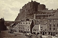
Edinburgh Castle from the Grassmarket, photographed by George Washington Wilson in 1865
| Wikisource has original text related to this article:
Edinburgh (1914) by Robert Louis Stevenson
|

Edinburgh, c. 1920
Despite an enduring myth to the contrary, Edinburgh became an industrial centre with its traditional industries of printing, brewing and distilling continuing to grow in the 19th century and joined by new industries such as rubber works, engineering works and others. By 1821, Edinburgh had been overtaken by Glasgow as Scotland’s largest city. The city centre between Princes Street and George Street became a major commercial and shopping district, a development partly stimulated by the arrival of railways in the 1840s. The Old Town became an increasingly dilapidated, overcrowded slum with high mortality rates. Improvements carried out under Lord Provost William Chambers in the 1860s began the transformation of the area into the predominantly Victorian Old Town seen today. More improvements followed in the early 20th century as a result of the work of Patrick Geddes, but relative economic stagnation during the two world wars and beyond saw the Old Town deteriorate further before major slum clearance in the 1960s and 1970s began to reverse the process. University building developments which transformed the George Square and Potterrow areas proved highly controversial.
Since the 1990s a new “financial district”, including the Edinburgh International Conference Centre, has grown mainly on demolished railway property to the west of the castle, stretching into Fountainbridge, a run-down 19th-century industrial suburb which has undergone radical change since the 1980s with the demise of industrial and brewery premises. This ongoing development has enabled Edinburgh to maintain its place as the United Kingdom’s second largest financial and administrative centre after London. Financial services now account for a third of all commercial office space in the city. The development of Edinburgh Park, a new business and technology park covering 38 acres (15 ha), 4 mi (6 km) west of the city centre, has also contributed to the District Council’s strategy for the city’s major economic regeneration.
In 1998, the Scotland Act, which came into force the following year, established a devolved Scottish Parliament and Scottish Executive (renamed the Scottish Government since September 2007). Both based in Edinburgh, they are responsible for governing Scotland while reserved matters such as defence, foreign affairs and some elements of income tax remain the responsibility of the Parliament of the United Kingdom in London.
Geography
Cityscape
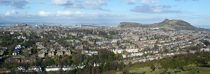
Situated in Scotland’s Central Belt, Edinburgh lies on the southern shore of the Firth of Forth. The city centre is 2+1⁄2 miles (4.0 km) southwest of the shoreline of Leith and 26 miles (42 km) inland, as the crow flies, from the east coast of Scotland and the North Sea at Dunbar. While the early burgh grew up near the prominent Castle Rock, the modern city is often said to be built on seven hills, namely Calton Hill, Corstorphine Hill, Craiglockhart Hill, Braid Hill, Blackford Hill, Arthur’s Seat and the Castle Rock, giving rise to allusions to the seven hills of Rome.
Occupying a narrow gap between the Firth of Forth to the north and the Pentland Hills and their outrunners to the south, the city sprawls over a landscape which is the product of early volcanic activity and later periods of intensive glaciation. :64–65 Igneous activity between 350 and 400 million years ago, coupled with faulting, led to the creation of tough basalt volcanic plugs, which predominate over much of the area.:64–65 One such example is the Castle Rock which forced the advancing ice sheet to divide, sheltering the softer rock and forming a 1-mile-long (1.6 km) tail of material to the east, thus creating a distinctive crag and tail formation.:64–65 Glacial erosion on the north side of the crag gouged a deep valley later filled by the now drained Nor Loch. These features, along with another hollow on the rock’s south side, formed an ideal natural strongpoint upon which Edinburgh Castle was built.:64–65 Similarly, Arthur’s Seat is the remains of a volcano dating from the Carboniferous period, which was eroded by a glacier moving west to east during the ice age.:64–65 Erosive action such as plucking and abrasion exposed the rocky crags to the west before leaving a tail of deposited glacial material swept to the east. This process formed the distinctive Salisbury Crags, a series of teschenite cliffs between Arthur’s Seat and the location of the early burgh. The residential areas of Marchmont and Bruntsfield are built along a series of drumlin ridges south of the city centre, which were deposited as the glacier receded.:64–65
Other prominent landforms such as Calton Hill and Corstorphine Hill are also products of glacial erosion.:64–65 The Braid Hills and Blackford Hill are a series of small summits to the south of the city centre that command expansive views looking northwards over the urban area to the Firth of Forth.:64–65
View of Edinburgh from Blackford Hill
Edinburgh is drained by the river named the Water of Leith, which rises at the Colzium Springs in the Pentland Hills and runs for 29 kilometres (18 mi) through the south and west of the city, emptying into the Firth of Forth at Leith. The nearest the river gets to the city centre is at Dean Village on the north-western edge of the New Town, where a deep gorge is spanned by Thomas Telford’s Dean Bridge, built in 1832 for the road to Queensferry. The Water of Leith Walkway is a mixed-use trail that follows the course of the river for 19.6 kilometres (12.2 mi) from Balerno to Leith.

Panorama of Edinburgh from Edinburgh Castle, with the New Town in the centre and Calton Hill to the right
Excepting the shoreline of the Firth of Forth, Edinburgh is encircled by a green belt, designated in 1957, which stretches from Dalmeny in the west to Prestongrange in the east. With an average width of 3.2 kilometres (2 mi) the principal objectives of the green belt were to contain the outward expansion of the city and to prevent the agglomeration of urban areas. Expansion affecting the green belt is strictly controlled but developments such as Edinburgh Airport and the Royal Highland Showground at Ingliston lie within the zone. Similarly, suburbs such as Juniper Green and Balerno are situated on green belt land. One feature of the Edinburgh green belt is the inclusion of parcels of land within the city which are designated green belt, even though they do not connect with the peripheral ring. Examples of these independent wedges of green belt include Holyrood Park and Corstorphine Hill.

Edinburgh Old Town skyline panorama
Areas
Edinburgh includes former towns and villages that retain much of their original character as settlements in existence before they were absorbed into the expanding city of the nineteenth and twentieth centuries. Many areas, such as Dalry, contain residences that are multi-occupancy buildings known as tenements, although the more southern and western parts of the city have traditionally been less built-up with a greater number of detached and semi-detached villas.

Map showing the areas of central Edinburgh
The historic centre of Edinburgh is divided in two by the broad green swathe of Princes Street Gardens. To the south, the view is dominated by Edinburgh Castle, built high on Castle Rock, and the long sweep of the Old Town descending towards Holyrood Palace. To the north lie Princes Street and the New Town.
The West End includes the financial district, with insurance and banking offices as well as the Edinburgh International Conference Centre.
Edinburgh’s Old and New Towns were listed as a UNESCO World Heritage Site in 1995 in recognition of the unique character of the Old Town with its medieval street layout and the planned Georgian New Town, including the adjoining Dean Village and Calton Hill areas. There are over 4,500 listed buildings within the city, a higher proportion relative to area than any other city in the United Kingdom.
The Royal Mile runs downhill and terminates at Holyrood Palace. Minor streets (called closes or wynds) lie on either side of the main spine forming a herringbone pattern. The street has several fine public buildings such as St Giles’ Cathedral, the City Chambers and the Law Courts. Other places of historical interest nearby are Greyfriars Kirkyard and the Grassmarket. The street layout is typical of the old quarters of many Northwestern European cities.
The castle is perched on top of a rocky crag (the remnant of an extinct volcano) and the Royal Mile runs down the crest of a ridge from it. Due to space restrictions imposed by the narrowness of this landform, the Old Town became home to some of the earliest “high rise” residential buildings. Multi-storey dwellings known as lands were the norm from the 16th century onwards with ten and eleven storeys being typical and one even reaching fourteen or fifteen storeys. Numerous vaults below street level were inhabited to accommodate the influx of incomers, particularly Irish immigrants, during the Industrial Revolution.
The New Town was an 18th-century solution to the problem of an increasingly crowded city which had been confined to the ridge sloping down from the castle. In 1766 a competition to design a “New Town” was won by James Craig, a 27-year-old architect. The plan was a rigid, ordered grid, which fitted in well with Enlightenment ideas of rationality. The principal street was to be George Street, running along the natural ridge to the north of what became known as the “Old Town”. To either side of it are two other main streets: Princes Street and Queen Street. Princes Street has become Edinburgh’s main shopping street and now has few of its Georgian buildings in their original state. The three main streets are connected by a series of streets running perpendicular to them. The east and west ends of George Street are terminated by St Andrew Square and Charlotte Square respectively. The latter, designed by Robert Adam, influenced the architectural style of the New Town into the early 19th century. Bute House, the official residence of the First Minister of Scotland, is on the north side of Charlotte Square.
The hollow between the Old and New Towns was formerly the Nor Loch, which was created for the town’s defence but came to be used by the inhabitants for dumping their sewage. It was drained by the 1820s as part of the city’s northward expansion. Craig’s original plan included an ornamental canal on the site of the loch, but this idea was abandoned. Soil excavated while laying the foundations of buildings in the New Town was dumped on the site of the loch to create the slope connecting the Old and New Towns known as The Mound.
In the middle of the 19th century the National Gallery of Scotland and Royal Scottish Academy Building were built on The Mound, and tunnels for the railway line between Haymarket and Waverley stations were driven through it.
The Southside is a residential part of the city, which includes the districts of St Leonards, Marchmont, Morningside, Newington, Sciennes, the Grange and Blackford. The Southside is broadly analogous to the area covered formerly by the Burgh Muir, and was developed as a residential area after the opening of the South Bridge in the 1780s. The Southside is particularly popular with families (many state and private schools are here), young professionals and students (the central University of Edinburgh campus is based around George Square just north of Marchmont and the Meadows), and Napier University (with major campuses around Merchiston and Morningside). The area is also well provided with hotel and “bed and breakfast” accommodation for visiting festival-goers. These districts often feature in works of fiction. For example, Church Hill in Morningside, was the home of Muriel Spark’s Miss Jean Brodie, and Ian Rankin’s Inspector Rebus lives in Marchmont and works in St Leonards.

The Shore, Leith
Leith was historically the port of Edinburgh, an arrangement of unknown date that was confirmed by the royal charter Robert the Bruce granted to the city in 1329. The port developed a separate identity from Edinburgh, which to some extent it still retains, and it was a matter of great resentment when the two burghs merged in 1920 into the City of Edinburgh. Even today the parliamentary seat is known as “Edinburgh North and Leith”. The loss of traditional industries and commerce (the last shipyard closed in 1983) resulted in economic decline. The Edinburgh Waterfront development has transformed old dockland areas from Leith to Granton into residential areas with shopping and leisure facilities and helped rejuvenate the area. With the redevelopment, Edinburgh has gained the business of cruise liner companies which now provide cruises to Norway, Sweden, Denmark, Germany, and the Netherlands.
The coastal suburb of Portobello is characterised by Georgian villas, Victorian tenements, a beach and promenade and cafés, bars, restaurants and independent shops. There are rowing and sailing clubs and a restored Victorian swimming pool, including Turkish baths.
The urban area of Edinburgh is almost entirely within the City of Edinburgh Council boundary, merging with Musselburgh in East Lothian. Towns within easy reach of the city boundary include Haddington, Tranent, Prestonpans, Dalkeith, Bonnyrigg, Loanhead, Penicuik, Broxburn, Livingston and Dunfermline. Edinburgh lies at the heart of the Edinburgh & South East Scotland City region with a population in 2014 of 1,339,380.
Climate
Like most of Scotland, Edinburgh has a cool, temperate, maritime climate which, despite its northerly latitude, is milder than places which lie at similar latitudes such as Moscow and Labrador. The city’s proximity to the sea mitigates any large variations in temperature or extremes of climate. Winter daytime temperatures rarely fall below freezing while summer temperatures are moderate, rarely exceeding 22 °C (72 °F). The highest temperature recorded in the city was 31.6 °C (88.9 °F) on 25 July 2019 at Gogarbank, beating the previous record of 31 °C (88 °F) on 4 August 1975 at Edinburgh Airport. The lowest temperature recorded in recent years was −14.6 °C (5.7 °F) during December 2010 at Gogarbank.
Given Edinburgh’s position between the coast and hills, it is renowned as “the windy city”, with the prevailing wind direction coming from the south-west, which is often associated with warm, unstable air from the North Atlantic Current that can give rise to rainfall – although considerably less than cities to the west, such as Glasgow. Rainfall is distributed fairly evenly throughout the year. Winds from an easterly direction are usually drier but considerably colder, and may be accompanied by haar, a persistent coastal fog. Vigorous Atlantic depressions, known as European windstorms, can affect the city between October and May.
Located slightly north of the city centre, the weather station at the Royal Botanic Garden Edinburgh (RBGE) has been an official weather station for the Met Office since 1956. The Met Office operates its own weather station at Gogarbank on the city’s western outskirts, near Edinburgh Airport. This slightly inland station has a slightly wider temperature span between seasons, is cloudier and somewhat wetter, but differences are minor.
Temperature and rainfall records have been kept at the Royal Observatory since 1764.
| hide | |||||||||||||
|---|---|---|---|---|---|---|---|---|---|---|---|---|---|
| Month | Jan | Feb | Mar | Apr | May | Jun | Jul | Aug | Sep | Oct | Nov | Dec | Year |
| Record high °C (°F) | 15.0 (59.0) |
15.2 (59.4) |
20.0 (68.0) |
22.8 (73.0) |
29.0 (84.2) |
27.8 (82.0) |
31.6 (88.9) |
31.4 (88.5) |
26.7 (80.1) |
24.4 (75.9) |
20.6 (69.1) |
15.4 (59.7) |
31.6 (88.9) |
| Average high °C (°F) | 7.0 (44.6) |
7.5 (45.5) |
9.5 (49.1) |
11.8 (53.2) |
14.7 (58.5) |
17.2 (63.0) |
19.1 (66.4) |
18.9 (66.0) |
16.5 (61.7) |
13.1 (55.6) |
9.6 (49.3) |
7.0 (44.6) |
12.7 (54.9) |
| Daily mean °C (°F) | 4.2 (39.6) |
4.5 (40.1) |
6.2 (43.2) |
8.1 (46.6) |
10.8 (51.4) |
13.5 (56.3) |
15.3 (59.5) |
15.2 (59.4) |
13.0 (55.4) |
9.8 (49.6) |
6.7 (44.1) |
4.2 (39.6) |
9.3 (48.7) |
| Average low °C (°F) | 1.4 (34.5) |
1.5 (34.7) |
2.8 (37.0) |
4.3 (39.7) |
6.8 (44.2) |
9.7 (49.5) |
11.5 (52.7) |
11.4 (52.5) |
9.4 (48.9) |
6.5 (43.7) |
3.7 (38.7) |
1.3 (34.3) |
5.9 (42.6) |
| Record low °C (°F) | −15.5 (4.1) |
−11.7 (10.9) |
−11.1 (12.0) |
−6.1 (21.0) |
−2.4 (27.7) |
1.1 (34.0) |
4.4 (39.9) |
2.2 (36.0) |
−1.1 (30.0) |
−3.7 (25.3) |
−8.3 (17.1) |
−11.5 (11.3) |
−15.5 (4.1) |
| Average precipitation mm (inches) | 67.5 (2.66) |
47.0 (1.85) |
51.7 (2.04) |
40.5 (1.59) |
48.9 (1.93) |
61.3 (2.41) |
65.0 (2.56) |
60.2 (2.37) |
63.7 (2.51) |
75.6 (2.98) |
62.1 (2.44) |
60.8 (2.39) |
704.3 (27.73) |
| Average precipitation days (≥ 1.0 mm) | 12.5 | 9.4 | 9.9 | 8.8 | 9.6 | 9.6 | 9.5 | 9.7 | 10.2 | 12.4 | 11.2 | 11.4 | 124.2 |
| Mean monthly sunshine hours | 53.5 | 78.5 | 114.8 | 144.6 | 188.4 | 165.9 | 172.2 | 161.5 | 128.8 | 101.2 | 71.0 | 46.2 | 1,426.6 |
| Average ultraviolet index | 0 | 1 | 2 | 3 | 5 | 5 | 5 | 5 | 3 | 1 | 1 | 0 | 3 |
| Source: Met Office, KNMI and Weather Atlas | |||||||||||||
| showClimate data for Edinburgh (Gogarbank), elevation: 57 m (187 ft), 1981–2010 normals |
|---|
- ^ Weather station is located 0.9 miles (1.4 km) from the Edinburgh city centre.
- ^ Weather station is located 5.9 miles (9.5 km) from the Edinburgh city centre.
Demography
Current
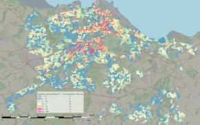
Population density map
The most recent official population estimates are 512,150 (2016) for the Edinburgh settlement (includes Musselburgh) and 518,500 (2018) for the local authority area.
Edinburgh has a high proportion of young adults, with 19.5% of the population in their 20s (exceeded only by Aberdeen) and 15.2% in their 30s which is the highest in Scotland. The proportion of Edinburgh’s population born in the UK fell from 92% to 84% between 2001 and 2011, while the proportion of White Scottish-born fell from 78% to 70%. Of those Edinburgh residents born in the UK, 335,000 or 83% were born in Scotland, with 58,000 or 14% being born in England.
| Ethnic group | 2001 | 2011 | ||
|---|---|---|---|---|
| Number | % | Number | % | |
| White: Scottish | 354,053 | 78.9% | 334,987 | 70.2% |
| White: Other British | 51,407 | 11.4% | 56,132 | 11.7% |
| White: Irish | 6,470 | 1.4% | 8,603 | 1.8% |
| White: other | 18,439 | 4.1% | 37,445 | 7.9% |
| White: total | 430,369 | 95.9% | 437,167 | 91.7% |
| Asian: | 11,600 | 2.5% | 26,264 | 5.5% |
| African: | 1,285 | 0.2% | 4,474 | 0.9% |
| Caribbean/Black: | 292† | <0.1% | 1,031 | 0.2% |
| Mixed/multiple: | 2,776†† | 0.6% | 4,087 | 0.8% |
| Other non-White: | 2,302 | 0.5% | 3,603 | 0.8% |
| Non-White: total | 18,255 | 4.0% | 39,459 | 8.2% |
| Total | 448,624 | 100.00% | 476,626 | 100.00% |
| † Caribbean as opposed to Caribbean Black†† Previously ‘mixed’ |
Some 13,000 people or 2.7% of the city’s population are of Polish descent. 39,500 people or 8.2% of Edinburgh’s population class themselves as Non-White which is an increase from 4% in 2001. Of the Non-White population, the largest group by far are Asian, totalling 26,264 people. Within the Asian population, people of Chinese descent are now the largest sub-group, with 8,076 people, amounting to about 1.7% of the city’s total population. The city’s population of Indian descent amounts to 6,470 (1.4% of the total population), while there are some 5,858 of Pakistani descent (1.2% of the total population). Although they account for only 1,277 people or 0.3% of the city’s population, Edinburgh has the highest number and proportion of people of Bangladeshi descent in Scotland. Over 7,000 people were born in African countries (1.6% of the total population) and nearly 7,000 in the Americas. With the notable exception of Inner London, Edinburgh has a higher number of people born in the United States (over 3,700) than any other city in the UK.
The proportion of people born outside the UK was 15.9% compared with 8% in 2001.
| Place of birth | Estimated resident population (2011) |
|---|---|
| 11,651 | |
| 4,888 | |
| 4,743 | |
| 4,188 | |
| 3,700 | |
| 3,500 | |
| 2,472 | |
| 2,100 | |
| 2,000 | |
| 2,000 | |
| 1,800 | |
| 1,800 | |
| 1,600 |
Historical
| Year | Pop. | ±% |
|---|---|---|
| 1801 | 82,560 | — |
| 1811 | 102,987 | +24.7% |
| 1821 | 138,235 | +34.2% |
| 1831 | 161,909 | +17.1% |
| 1841 | 166,450 | +2.8% |
| 1851 | 193,929 | +16.5% |
| 1901 | 303,638 | +56.6% |
| 1911 | 320,318 | +5.5% |
| 1921 | 420,264 | +31.2% |
| 1931 | 439,010 | +4.5% |
| 1951 | 466,761 | +6.3% |
| Source: |
||
A census by the Edinburgh presbytery in 1592 recorded a population of 8,003 adults spread equally north and south of the High Street which runs along the spine of the ridge sloping down from the Castle. In the 18th and 19th centuries, the population expanded rapidly, rising from 49,000 in 1751 to 136,000 in 1831, primarily due to migration from rural areas.:9 As the population grew, problems of overcrowding in the Old Town, particularly in the cramped tenements that lined the present day Royal Mile and the Cowgate, were exacerbated.:9 Poor sanitary arrangements resulted in a high incidence of disease,:9 with outbreaks of cholera occurring in 1832, 1848 and 1866.
The construction of the New Town from 1767 onwards witnessed the migration of the professional and business classes from the difficult living conditions in the Old Town to the lower density, higher quality surroundings taking shape on land to the north. Expansion southwards from the Old Town saw more tenements being built in the 19th century, giving rise to Victorian suburbs such as Dalry, Newington, Marchmont and Bruntsfield.
Early 20th-century population growth coincided with lower-density suburban development. As the city expanded to the south and west, detached and semi-detached villas with large gardens replaced tenements as the predominant building style. Nonetheless, the 2001 census revealed that over 55% of Edinburgh’s population were still living in tenements or blocks of flats, a figure in line with other Scottish cities, but much higher than other British cities, and even central London.
From the early to mid 20th century, the growth in population, together with slum clearance in the Old Town and other areas, such as Dumbiedykes, Leith, and Fountainbridge, led to the creation of new estates such as Stenhouse and Saughton, Craigmillar and Niddrie, Pilton and Muirhouse, Piershill, and Sighthill.
Religion

The High Kirk of Edinburgh, also known as St Giles’ Cathedral
In 2018 the Church of Scotland had 20,956 members in 71 congregations in the Presbytery of Edinburgh. Its most prominent church is St Giles’ on the Royal Mile, first dedicated in 1243 but believed to date from before the 12th century. Saint Giles is historically the patron saint of Edinburgh. St Cuthbert’s, situated at the west end of Princes Street Gardens in the shadow of Edinburgh Castle and St Giles’ can lay claim to being the oldest Christian sites in the city, though the present St Cuthbert’s, designed by Hippolyte Blanc, was dedicated in 1894.
Other Church of Scotland churches include Greyfriars Kirk, the Canongate Kirk, St Andrew’s and St George’s West Church and the Barclay Church. The Church of Scotland Offices are in Edinburgh, as is the Assembly Hall where the annual General Assembly is held.
The Roman Catholic Archdiocese of St Andrews and Edinburgh has 27 parishes across the city. The Archbishop of St Andrews and Edinburgh has his official residence in Greenhill, and the diocesan offices are in nearby Marchmont. The Diocese of Edinburgh of the Scottish Episcopal Church has over 50 churches, half of them in the city. Its centre is the late-19th-century Gothic style St Mary’s Cathedral in the West End’s Palmerston Place. Orthodox Christianity is represented by Pan, Romanian and Russian Orthodox churches. There are several independent churches in the city, both Catholic and Protestant, including Charlotte Chapel, Carrubbers Christian Centre, Bellevue Chapel and Sacred Heart. There are also churches belonging to Quakers, Christadelphians, Seventh-day Adventists, Church of Christ, Scientist, The Church of Jesus Christ of Latter-day Saints (LDS Church) and Elim Pentecostal Church.
Muslims have several places of worship across the city. Edinburgh Central Mosque, the largest Islamic place of worship, is located in Potterrow on the city’s Southside, near Bristo Square. Construction was largely financed by a gift from King Fahd of Saudi Arabia and was completed in 1998. There is also an Ahmadiyya Muslim community.
The first recorded presence of a Jewish community in Edinburgh dates back to the late 18th century. Edinburgh’s Orthodox synagogue, opened in 1932, is in Salisbury Road and can accommodate a congregation of 2000. A Liberal Jewish congregation also meets in the city.
A Sikh gurdwara and a Hindu mandir are located in Leith. The city also has a Brahma Kumaris centre in the Polwarth area.
The Edinburgh Buddhist Centre, run by the Triratna Buddhist Community, formerly situated in Melville Terrace, now runs sessions at the Healthy Life Centre, Bread Street. Other Buddhist traditions are represented by groups which meet in the capital: the Community of Interbeing (followers of Thich Nhat Hanh), Rigpa, Samye Dzong, Theravadin, Pure Land and Shambala. There is a Sōtō Zen Priory in Portobello and a Theravadin Thai Buddhist Monastery in Slateford Road.
Edinburgh is home to a Baháʼí community, and a Theosophical Society meets in Great King Street.
Edinburgh has an Inter-Faith Association.
Edinburgh has over 39 graveyards and cemeteries, many of which are listed and of historical character, including several former church burial grounds. Examples include Old Calton Burial Ground, Greyfriars Kirkyard and Dean Cemetery.
Economy

The Bank of Scotland’s head office in central Edinburgh
Edinburgh has the strongest economy of any city in the United Kingdom outside London and the highest percentage of professionals in the UK with 43% of the population holding a degree-level or professional qualification. According to the Centre for International Competitiveness, it is the most competitive large city in the United Kingdom. It also has the highest gross value added per employee of any city in the UK outside London, measuring £57,594 in 2010. It was named European Best Large City of the Future for Foreign Direct Investment and Best Large City for Foreign Direct Investment Strategy in the Financial Times fDi magazine awards 2012/13.