
The Köppen climate classification is one of the most widely used climate classification systems. It was first published by German-Russian climatologist Wladimir Köppen (1846–1940) in 1884, with several later modifications by Köppen, notably in 1918 and 1936. Later, the climatologist Rudolf Geiger (1894-1981) introduced some changes to the classification system, which is thus sometimes called the Köppen–Geiger climate classification system.
The Köppen climate classification divides climates into five main climate groups, with each group being divided based on seasonal precipitation and temperature patterns. The five main groups are A (tropical), B (dry), C (temperate), D (continental), and E (polar). Each group and subgroup is represented by a letter. All climates are assigned a main group (the first letter). All climates except for those in the E group are assigned a seasonal precipitation subgroup (the second letter). For example, Af indicates a tropical rainforest climate. The system assigns a temperature subgroup for all groups other than those in the A group, indicated by the third letter for climates in B, C, and D, and the second letter for climates in E. For example, Cfb indicates an oceanic climate with warm summers as indicated by the ending b. Climates are classified based on specific criteria unique to each climate type.
As Köppen designed the system based on his experience as a botanist, his main climate groups are based on what types of vegetation grow in a given climate classification region. In addition to identifying climates, the system can be used to analyze ecosystem conditions and identify the main types of vegetation within climates. Due to its link with the plant life of a given region, the system is useful in predicting future changes in plant life within that region.
The Köppen climate classification system has been further modified, within the Trewartha climate classification system in the middle 1960s (revised in 1980). The Trewartha system sought to create a more refined middle latitude climate zone, which was one of the criticisms of the Köppen system (the C climate group was too broad).:200–1
Overview
| 1st | 2nd | 3rd |
|---|---|---|
| A (Tropical) | f (Rainforest) | |
| m (Monsoon) | ||
| w (Savanna, Dry winter) | ||
| s (Savanna, Dry summer) | ||
| B (Arid) | W (Desert) | |
| S (Steppe) | ||
| h (Hot) | ||
| k (Cold) | ||
| C (Temperate) | w (Dry winter) | |
| f (No dry season) | ||
| s (Dry summer) | ||
| a (Hot summer) | ||
| b (Warm summer) | ||
| c (Cold summer) | ||
| D (Continental) | w (Dry winter) | |
| f (No dry season) | ||
| s (Dry summer) | ||
| a (Hot summer) | ||
| b (Warm summer) | ||
| c (Cold summer) | ||
| d (Very cold winter) | ||
| E (Polar) | T (Tundra) | |
| F (Eternal frost (ice cap)) |
The Köppen climate classification scheme divides climates into five main climate groups: A (tropical), B (dry), C (temperate), D (continental), and E (polar). The second letter indicates the seasonal precipitation type, while the third letter indicates the level of heat. Summers are defined as the 6-month period that is warmer either from April–September and/or October–March while winter is the 6-month period that is cooler.
Group A: Tropical climates
This type of climate has every month of the year with an average temperature of 18 °C (64.4 °F) or higher, with significant precipitation.
- Af = Tropical rainforest climate; average precipitation of at least 60 mm (2.4 in) in every month.
- Am = Tropical monsoon climate; driest month (which nearly always occurs at or soon after the “winter” solstice for that side of the equator) with precipitation less than 60 mm (2.4 in), but at least {\textstyle 100-\left({\frac {\mathrm {Total\,Annual\,Precipitation\,(mm)} }{25}}\right)}.
- Aw or As = Tropical wet and dry or savanna climate; with the driest month having precipitation less than 60 mm (2.4 in) and less than {\textstyle 100-\left({\frac {\mathrm {Total\,Annual\,Precipitation\,(mm)} }{25}}\right)}.

Group B: Dry climates
This type of climate is defined by little precipitation that does not fit the polar (EF or ET) criteria of no month with an average temperature lower than 10 °C (50 °F).
The threshold in millimeters is determined by multiplying the average annual temperature in Celsius by 20, then adding:
- (a) 280 if 70% or more of the total precipitation is in the spring and summer months (April–September in the Northern Hemisphere, or October–March in the Southern), or
- (b) 140 if 30%–70% of the total precipitation is received during the spring and summer, or
- (c) 0 if less than 30% of the total precipitation is received during the spring and summer.
If the annual precipitation is less than 50% of this threshold, the classification is BW (arid: desert climate); if it is in the range of 50%–100% of the threshold, the classification is BS (semi-arid: steppe climate).
A third letter can be included to indicate temperature. Originally, h signified low-latitude climate (average annual temperature above 18 °C (64.4 °F)) while k signified middle-latitude climate (average annual temperature below 18 °C), but the more common practice today, especially in the United States, is to use h to mean the coldest month has an average temperature above 0 °C (32 °F) (or −3 °C (27 °F)), with k denoting that at least one month’s averages below 0 °C (or −3 °C (27 °F)). In addition, n is used to denote a climate characterized by frequent fog and H for high altitudes.
- BWh = Hot desert climate
- BWk = Cold desert climate
- BSh = Hot semi-arid climate
- BSk = Cold semi-arid climate
Group C: Temperate climates
This type of climate has the coldest month averaging between 0 °C (32 °F) (or −3 °C (27 °F)) and 18 °C (64.4 °F) and at least one month averaging above 10 °C (50 °F). For the distribution of precipitation in locations that both satisfy a dry summer (CS) and a dry winter (CW), a location is considered to have a wet summer (CW) when more precipitation falls within the summer months than the winter months while a location is considered to have a dry summer (CS) when more precipitation falls within the winter months. This additional criterion applies to locations that satisfies both DS and DW as well.
- Cfa = Humid subtropical climate; coldest month averaging above 0 °C (32 °F) (or −3 °C (27 °F)), at least one month’s average temperature above 22 °C (71.6 °F), and at least four months averaging above 10 °C (50 °F). No significant precipitation difference between seasons (neither abovementioned set of conditions fulfilled). No dry months in the summer.
- Cfb = Temperate oceanic climate; coldest month averaging above 0 °C (32 °F) (or −3 °C (27 °F)), all months with average temperatures below 22 °C (71.6 °F), and at least four months averaging above 10 °C (50 °F). No significant precipitation difference between seasons (neither abovementioned set of conditions fulfilled).
- Cfc = Subpolar oceanic climate; coldest month averaging above 0 °C (32 °F) (or −3 °C (27 °F)) and 1–3 months averaging above 10 °C (50 °F). No significant precipitation difference between seasons (neither abovementioned set of conditions fulfilled).
- Cwa = Monsoon-influenced humid subtropical climate; coldest month averaging above 0 °C (32 °F) (or −3 °C (27 °F)), at least one month’s average temperature above 22 °C (71.6 °F), and at least four months averaging above 10 °C (50 °F). At least ten times as much rain in the wettest month of summer as in the driest month of winter (alternative definition is 70% or more of average annual precipitation is received in the warmest six months).
- Cwb = Subtropical highland climate or Monsoon-influenced temperate oceanic climate; coldest month averaging above 0 °C (32 °F) (or −3 °C (27 °F)), all months with average temperatures below 22 °C (71.6 °F), and at least four months averaging above 10 °C (50 °F). At least ten times as much rain in the wettest month of summer as in the driest month of winter (an alternative definition is 70% or more of average annual precipitation received in the warmest six months).
- Cwc = Cold subtropical highland climate or Monsoon-influenced subpolar oceanic climate; coldest month averaging above 0 °C (32 °F) (or −3 °C (27 °F)) and 1–3 months averaging above 10 °C (50 °F). At least ten times as much rain in the wettest month of summer as in the driest month of winter (alternative definition is 70% or more of average annual precipitation is received in the warmest six months).
- Csa = Hot-summer Mediterranean climate; coldest month averaging above 0 °C (32 °F) (or −3 °C (27 °F)), at least one month’s average temperature above 22 °C (71.6 °F), and at least four months averaging above 10 °C (50 °F). At least three times as much precipitation in the wettest month of winter as in the driest month of summer, and driest month of summer receives less than 40 mm (1.6 in).
- Csb = Warm-summer Mediterranean climate; coldest month averaging above 0 °C (32 °F) (or −3 °C (27 °F)), all months with average temperatures below 22 °C (71.6 °F), and at least four months averaging above 10 °C (50 °F). At least three times as much precipitation in the wettest month of winter as in the driest month of summer, and driest month of summer receives less than 40 mm (1.6 in).
- Csc = Cold-summer Mediterranean climate; coldest month averaging above 0 °C (32 °F) (or −3 °C (27 °F)) and 1–3 months averaging above 10 °C (50 °F). At least three times as much precipitation in the wettest month of winter as in the driest month of summer, and driest month of summer receives less than 40 mm (1.6 in).
Group D: Continental climates
This type of climate has at least one month averaging below 0 °C (32 °F) (or −3 °C (27 °F)) and at least one month averaging above 10 °C (50 °F).
- Dfa = Hot-summer humid continental climate; coldest month averaging below 0 °C (32 °F) (or −3 °C (27 °F)), at least one month’s average temperature above 22 °C (71.6 °F), and at least four months averaging above 10 °C (50 °F). No significant precipitation difference between seasons (neither abovementioned set of conditions fulfilled).
- Dfb = Warm-summer humid continental climate; coldest month averaging below 0 °C (32 °F) (or −3 °C (27 °F)), all months with average temperatures below 22 °C (71.6 °F), and at least four months averaging above 10 °C (50 °F). No significant precipitation difference between seasons (neither abovementioned set of conditions fulfilled).
- Dfc = Subarctic climate; coldest month averaging below 0 °C (32 °F) (or −3 °C (27 °F)) and 1–3 months averaging above 10 °C (50 °F). No significant precipitation difference between seasons (neither abovementioned set of conditions fulfilled).
- Dfd = Extremely cold subarctic climate; coldest month averaging below −38 °C (−36.4 °F) and 1–3 months averaging above 10 °C (50 °F). No significant precipitation difference between seasons (neither abovementioned set of conditions fulfilled).
- Dwa = Monsoon-influenced hot-summer humid continental climate; coldest month averaging below 0 °C (32 °F) (or −3 °C (27 °F)), at least one month’s average temperature above 22 °C (71.6 °F), and at least four months averaging above 10 °C (50 °F). At least ten times as much rain in the wettest month of summer as in the driest month of winter (alternative definition is 70% or more of average annual precipitation is received in the warmest six months).
- Dwb = Monsoon-influenced warm-summer humid continental climate; coldest month averaging below 0 °C (32 °F) (or −3 °C (27 °F)), all months with average temperatures below 22 °C (71.6 °F), and at least four months averaging above 10 °C (50 °F). At least ten times as much rain in the wettest month of summer as in the driest month of winter (alternative definition is 70% or more of average annual precipitation is received in the warmest six months).
- Dwc = Monsoon-influenced subarctic climate; coldest month averaging below 0 °C (32 °F) (or −3 °C (27 °F)) and 1–3 months averaging above 10 °C (50 °F). At least ten times as much rain in the wettest month of summer as in the driest month of winter (alternative definition is 70% or more of average annual precipitation is received in the warmest six months).
- Dwd = Monsoon-influenced extremely cold subarctic climate; coldest month averaging below −38 °C (−36.4 °F) and 1–3 months averaging above 10 °C (50 °F). At least ten times as much rain in the wettest month of summer as in the driest month of winter (alternative definition is 70% or more of average annual precipitation is received in the warmest six months).
- Dsa = Mediterranean-influenced hot-summer humid continental climate; coldest month averaging below 0 °C (32 °F) (or −3 °C (27 °F)), average temperature of the warmest month above 22 °C (71.6 °F) and at least four months averaging above 10 °C (50 °F). At least three times as much precipitation in the wettest month of winter as in the driest month of summer, and driest month of summer receives less than 30 mm (1.2 in).
- Dsb = Mediterranean-influenced warm-summer humid continental climate; coldest month averaging below 0 °C (32 °F) (or −3 °C (27 °F)), average temperature of the warmest month below 22 °C (71.6 °F) and at least four months averaging above 10 °C (50 °F). At least three times as much precipitation in the wettest month of winter as in the driest month of summer, and driest month of summer receives less than 30 mm (1.2 in).
- Dsc = Mediterranean-influenced subarctic climate; coldest month averaging below 0 °C (32 °F) (or −3 °C (27 °F)) and 1–3 months averaging above 10 °C (50 °F). At least three times as much precipitation in the wettest month of winter as in the driest month of summer, and driest month of summer receives less than 30 mm (1.2 in).
- Dsd = Mediterranean-influenced extremely cold subarctic climate; coldest month averaging below −38 °C (−36.4 °F) and 1–3 months averaging above 10 °C (50 °F). At least three times as much precipitation in the wettest month of winter as in the driest month of summer, and driest month of summer receives less than 30 mm (1.2 in).
Group E: Polar and alpine climates
This type of climate has every month of the year with an average temperature below 10 °C (50 °F).
- ET = Tundra climate; average temperature of warmest month between 0 °C (32 °F) and 10 °C (50 °F).
- EF = Ice cap climate; eternal winter, with all 12 months of the year with average temperatures below 0 °C (32 °F).
Group A: Tropical/megathermal climates

Tropical climate distribution
Tropical climates are characterized by constant high temperatures (at sea level and low elevations); all 12 months of the year have average temperatures of 18 °C (64.4 °F) or higher; and generally high annual precipitation. They are subdivided as follows:
Af: Tropical rainforest climate
All 12 months have an average precipitation of at least 60 mm (2.4 in). These climates usually occur within 10° latitude of the equator. This climate has no natural seasons in terms of thermal and moisture changes. When it is dominated most of the year by the doldrums low-pressure system due to the presence of the Intertropical Convergence Zone (ITCZ) and when there are no cyclones then the climate is qualified as equatorial. When the trade winds are dominant most of the year, the climate is a tropical trade-wind rainforest climate.
Examples
|
|
Some of the places with this climate are indeed uniformly and monotonously wet throughout the year (e.g., the northwest Pacific coast of South and Central America, from Ecuador to Costa Rica; see, for instance, Andagoya, Colombia), but in many cases, the period of higher sun and longer days is distinctly wettest (as at Palembang, Indonesia) or the time of lower sun and shorter days may have more rain (as at Sitiawan, Malaysia). Among these places some have a pure equatorial climate (Balikpapan, Kuala Lumpur, Kuching, Lae, Medan, Paramaribo, Pontianak and Singapore) with the dominant ITCZ aerological mechanism and no cyclones or a subequatorial climate with occasional cyclones (Davao, Ratnapura, Victoria).
(Note. The term aseasonal refers to the lack in the tropical zone of large differences in daylight hours and mean monthly (or daily) temperature throughout the year. Annual cyclic changes occur in the tropics, but not as predictably as those in the temperate zone, albeit unrelated to temperature, but to water availability whether as rain, mist, soil, or ground water. Plant response (e. g., phenology), animal (feeding, migration, reproduction, etc.), and human activities (plant sowing, harvesting, hunting, fishing, etc.) are tuned to this ‘seasonality’. Indeed, in tropical South America and Central America, the ‘rainy season’ (and the ‘high water season’) is called invierno or inverno, though it could occur in the Northern Hemisphere summer; likewise, the ‘dry season’ (and ‘low water season’) is called verano or verão, and can occur in the Northern Hemisphere winter).
Am: Tropical monsoon climate
This type of climate results from the monsoon winds which change direction according to the seasons. This climate has a driest month (which nearly always occurs at or soon after the “winter” solstice for that side of the equator) with rainfall less than 60 mm (2.4 in), but at least {\textstyle 100-\left({\frac {Total\ Annual\ Precipitation\ (mm)}{25}}\right)} of average monthly precipitation.:208

Examples
|
|
Aw/As: Tropical savanna climate
Aw: Tropical savanna climate with dry-winter characteristics
Aw climates have a pronounced dry season, with the driest month having precipitation less than 60 mm (2.4 in) and less than {\textstyle 100-\left({\frac {Total\ Annual\ Precipitation\ (mm)}{25}}\right)} of average monthly precipitation. :208–11
Examples
|
|
Most places that have this climate are found at the outer margins of the tropical zone from the low teens to the mid-20s latitudes, but occasionally an inner-tropical location (e.g., San Marcos, Antioquia, Colombia) also qualifies. Actually, the Caribbean coast, eastward from the Gulf of Urabá on the Colombia–Panamá border to the Orinoco River delta, on the Atlantic Ocean (about 4,000 km), have long dry periods (the extreme is the BSh climate (see below), characterised by very low, unreliable precipitation, present, for instance, in extensive areas in the Guajira, and Coro, western Venezuela, the northernmost peninsulas in South America, which receive <300 mm total annual precipitation, practically all in two or three months).
This condition extends to the Lesser Antilles and Greater Antilles forming the circum-Caribbean dry belt. The length and severity of the dry season diminishes inland (southward); at the latitude of the Amazon River—which flows eastward, just south of the equatorial line—the climate is Af. East from the Andes, between the dry, arid Caribbean and the ever-wet Amazon are the Orinoco River’s Llanos or savannas, from where this climate takes its name.
As: Tropical savanna climate with dry-summer characteristics
Sometimes As is used in place of Aw if the dry season occurs during the time of higher sun and longer days (during summer). This is the case in parts of Hawaii, northwestern Dominican Republic, East Africa, and the Brazilian Northeastern Coast. In most places that have tropical wet and dry climates, however, the dry season occurs during the time of lower sun and shorter days because of rain shadow effects during the ‘high-sun’ part of the year.
Examples
|
|
Group B: Dry (desert and semi-arid) climates

Dry climate distribution
These climates are characterized by the amount of annual precipitation less than a threshold value which approximates the potential evapotranspiration.:212 The threshold value (in millimeters) is calculated as follows:
Multiply the average annual temperature in °C by 20, then add
- (a) 280 if 70% or more of the total precipitation is in the high-sun half of the year (April through September in the Northern Hemisphere, or October through March in the Southern), or
- (b) 140 if 30%–70% of the total precipitation is received during the applicable period, or
- (c) 0 if less than 30% of the total precipitation is so received.
According to the modified Köppen classification system used by modern climatologists, total precipitation in the warmest six months of the year is taken as reference instead of the total precipitation in the high-sun half of the year.
If the annual precipitation is less than 50% of this threshold, the classification is BW (arid: desert climate); if it is in the range of 50%–100% of the threshold, the classification is BS (semi-arid: steppe climate).
A third letter can be included to indicate temperature. Originally, h signified low-latitude climate (average annual temperature above 18 °C) while k signified middle-latitude climate (average annual temperature below 18 °C), but the more common practice today, especially in the United States, is to use h to mean the coldest month has an average temperature above 0 °C (32 °F) (or −3 °C (27 °F)), with k denoting that at least one month averages below 0 °C.
Desert areas situated along the west coasts of continents at tropical or near-tropical locations characterized by frequent fog and low clouds, despite the fact that these places rank among the driest on earth in terms of actual precipitation received are labelled BWn with the n denoting a climate characterized by frequent fog. The BSn category can be found in foggy coastal steppes.
BW: Arid climate
Hot desert
|
|
Cold desert
- Albuquerque, New Mexico, United States (BWk, bordering on BSk)
- Aral, Kazakhstan (BWk)
- Ashgabat, Turkmenistan (BWk)
- Ciudad Juárez, Chihuahua, Mexico (BWk, bordering on BWh)
- Damascus, Syria (BWk)
- El Paso, Texas, United States (BWk, bordering on BWh)
- Isfahan, Iran (BWk)
- Leh, India (BWk)
- Neuquén, Argentina (BWk)
- Nukus, Uzbekistan (BWk)
- Saint George, Utah, United States (BWk, bordering on BWh)
- Sanaa, Yemen (BWk, bordering on BSk)
- Turpan, Xinjiang, China (BWk)
- Walvis Bay, Erongo Region, Namibia (BWk)
BS: Semi-arid (steppe) climate
Hot semi-arid
|
|
Cold semi-arid
|
|
Group C: Temperate/mesothermal climates
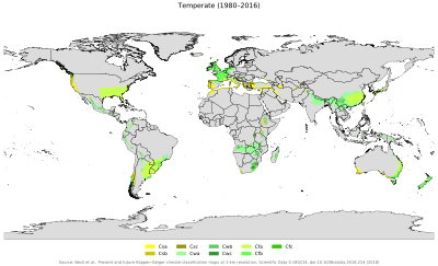
Temperate climate distribution
In the Köppen climate system, temperate climates are defined as having an average temperature above 0 °C (32 °F) (or −3 °C (26.6 °F), as noted previously) in their coldest month but below 18 °C (64.4 °F). The average temperature of −3 °C (26.6 °F) roughly coincides with the equatorward limit of frozen ground and snowcover lasting for a month or more.
The second letter indicates the precipitation pattern—w indicates dry winters (driest winter month average precipitation less than one-tenth wettest summer month average precipitation. s indicates at least three times as much rain in the wettest month of winter as in the driest month of summer. f means significant precipitation in all seasons (neither above-mentioned set of conditions fulfilled).
The third letter indicates the degree of summer heat—a indicates warmest month average temperature above 22 °C (71.6 °F) while b indicates warmest month averaging below 22 °C but with at least four months averaging above 10 °C (50.0 °F), and c indicates one to three months averaging above 10 °C (50.0 °F).
Csa: Mediterranean hot summer climates
These climates usually occur on the western sides of continents between the latitudes of 30° and 45°. These climates are in the polar front region in winter, and thus have moderate temperatures and changeable, rainy weather. Summers are hot and dry, due to the domination of the subtropical high pressure systems, except in the immediate coastal areas, where summers are milder due to the nearby presence of cold ocean currents that may bring fog but prevent rain.:221–3
Examples
|
|
Csb: Mediterranean warm/cool summer climates
Dry-summer climates sometimes extend to additional areas (sometimes well north or south of) typical Mediterranean climates, however since their warmest month average temperatures do not reach 22 °C (71.6 °F) they are classified as Csb. Some of these areas would border the oceanic climate (Cfb), except their dry-summer patterns meet Köppen’s Cs minimum thresholds.
Examples
|
|
Csc: Mediterranean cold summer climates
Cold summer Mediterranean climates (Csc) exist in high-elevation areas adjacent to coastal Csb climate areas, where the strong maritime influence prevents the average winter monthly temperature from dropping below 0 °C. This climate is rare and is predominantly found in climate fringes and isolated areas of the Cascades and Andes Mountains, as the dry-summer climate extends further poleward in the Americas than elsewhere. Rare instances of this climate can be found in some coastal locations in the North Atlantic and at high altitudes in Hawaii.
Examples
|
|
Cfa: Humid subtropical climates
These climates usually occur on the eastern coasts and eastern sides of continents, usually in the high 20s and 30s latitudes. Unlike the dry summer Mediterranean climates, humid subtropical climates have a warm and wet flow from the tropics that creates warm and moist conditions in the summer months. As such, summer (not winter as is the case in Mediterranean climates) is often the wettest season.
The flow out of the subtropical highs and the summer monsoon creates a southerly flow from the tropics that brings warm and moist air to the lower east sides of continents. This flow is often what brings the frequent but short-lived summer thundershowers so typical of the more southerly subtropical climates like the southern United States, southern China and Japan.:223–6
Examples
|
|
Cfb: Oceanic climate
Marine west coast climate
Cfb climates usually occur in the higher middle latitudes on the western sides of continents between the latitudes of 40° and 60°; they are typically situated immediately poleward of the Mediterranean climates. However, in southeast Australia, southeast South America, and extreme southern Africa this climate is found immediately poleward of temperate climates, on places near the coast and at a somewhat lower latitude. In western Europe, this climate occurs in coastal areas up to 68°N in Norway.
These climates are dominated all year round by the polar front, leading to changeable, often overcast weather. Summers are mild due to cool ocean currents. Winters are milder than other climates in similar latitudes, but usually very cloudy, and frequently wet. Cfb climates are also encountered at high elevations in certain subtropical and tropical areas, where the climate would be that of a subtropical/tropical rain forest if not for the altitude. These climates are called “highlands”.:226–9
Examples
|