
Barabanki district
is one of the five districts of Faizabad division (officially Ayodhya division), in the central Awadh region of Uttar Pradesh, India. Barabanki city is the administrative headquarters of Barabanki district. Total area of Barabanki district is 3891.5 Sq. Km.
It has a population of 2,673,581, with a population density of 686.50 per square kilometre (1,778.0/sq mi).
Barabanki district is situated between 27°19′ and 26°30′ north latitude, and 80°05′ and 81°51′ east longitude; it runs in a south-easterly direction, confined by the nearly parallel streams of the Ghaghara and Gomti. The extreme length of the district from east to west may be taken at 92 km (57 mi), and the extreme breadth at 93 km (58 mi); the total area is about 3,900 km2 (1,504 sq mi). It borders seven other districts of Uttar Pradesh. With its most northern point it shares borders with the Sitapur district, while its north-eastern boundary is defined by the Ghagra, beyond which lie the districts of Bahraich district and Gonda district. Its eastern border is shared with Faizabad district, and the Gomti forms a natural boundary to the south, dividing it from the Amethi district. On the west, it adjoins the Lucknow district.
In 1856, the district came, with the rest of Oudh State, under British rule. During the Indian Rebellion of 1857, the whole of the Barabanki talukdars joined the mutineers, but offered no serious resistance following the capture of Lucknow.
Barabanki district stretches out in a level plain interspersed with numerous lakes and marshes. In the upper part of the district the soil is sandy, while in the lower part it is clay and produces finer crops. The district is fed by the rivers Ghaghra (forming the northern boundary), Gomti (flowing through the middle of the district), Kalyani and Rait and their tributaries, for the major part of the year. Some rivers dry out in the summer, and become flooded during the rainy season. The changing course of the river Ghagra alters the land area of the district.
The principal crops are rice, wheat, pulse and other food grains and sugarcane. Both of the bordering rivers of Barabanki are navigable. The district is traversed by two lines of the Northern Railway and North-Eastern Railway, with branches having total length of 131 km (81 mi). The district roadways include connections to National Highway 28, state highways and various link roads.
Etymology

Barabanki Clock Arch
The area was once known as Jasnaul, from Jas, a Raja of the Bhar tribe, who is said to have founded it before 1000 AD. Following the Muslim conquest, the lands were divided into twelve, with the new owners quarrelling so incessantly that they were called the Barah Banke, or twelve quarrelsome men. Banka, in Awadhi, meaning a bully or brave. Others derive the name from ban, meaning wood or jungle, and interpret Barabanki as the twelve shares of jungle.
History
The current Barabanki district was first established by the British upon their annexation of Oudh State in 1856. Originally, the district was known as Daryabad district because its headquarters were at Daryabad, but in 1859 they were relocated to Barabanki. The name “Barabanki” was chosen for the district’s official name over “Nawabganj”, then the more common name of the town, for two reasons: first, to avoid any possible confusion with other places calleed Nawabganj, and second, because the civil station was technically located outside of Nawabganj in the small revenue village of Barabanki. Previously, under the Nawabs of Awadh, the area that would become Barabanki district was divided between five chaklas: Daryabad-Rudauli, Ramnagar, Dewa-Jahangirabad, Jagdispur, and Haidargarh.
Early history and legends
Barabanki district is mostly within what was the Pachhimrath division of the kingdom of Rama.

Parijat tree at Kintoor, Barabanki
Parijaat tree is a protected baobab tree in the village of Kintoor, and is considered sacred to Hindus. Located near the Kunteshwar Mahadeva temple (established by Kunti), the tree is said to grow from Kunti’s ashes. The tree is very old, though its age has not been scientifically determined.
Before 1000 AD, Jas, a raja of the Bhar tribe, is said to have founded the locality of Jasnaul which later became Barabanki.
Medieval India
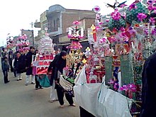
Indian Shia Muslims take out a Ta’ziya procession on day of Ashura in Barabanki, India, Jan 2009.
Muslims made their first permanent settlement in what is now the district at Satrikh, in 1030 AD (421 AH). The Muslim conquest saw Sihali conquered and its sovereign killed, as with Kintur. Bhar-Pasi chief Sohil Deo (or Sohel Dal) of Sahet-Mahet and Rathor monarch Sri Chandradeo of Kannauj fought a battle in Satrikh village of the district.
In 1049 AD (441 AH), the kings of Kanauj and Manikpur were defeated and driven from Oudh by Qutub-ud-din of Medina. The Muslim invasion was more successful in Bara Banki than elsewhere. In 1189 AD (586 AH), Sihali was conquered by Shekh Nizam-ud-din of Herat, Ansari. Zaidpur was occupied by them in 636 AH, when Sayyad Abd-ul-Wahid turned out the Bhar-pasi, changing the name of the town from Suhalpur. The colony of Musalman Bhattis is reported to have arrived about the same time, although some place it as early as 1199 AD (596 AH). They came from Bhatnair or Bhattiana, in the Punjab and Rajputana and settled at Mawai Maholara.
From 1350 to about 1750 AD, Muslim immigrants settled in great number in the district. The Muslims first permanently settled in Oudh.
Rudauli was occupied c. 700 AH, in the reign of Alla-ud-din Khilji, whose forces had destroyed nearly every remaining seat of Chhattri power. Rasulpur was conquered about 1350 AD. Daryabad was founded about 1444 AD by Dariab Khan Subahdar and his brother Fateh Khan colonized. Fatehpur. The villages of Barauli and Barai, near Rudauli, were occupied and became large estates until about the middle of the fifteenth century.
Simultaneously, however, with this latter immigration of the Muslims, there was one of Chhattris. The mysterious tribe of Kalhans, which numbers some twenty thousand persons, are said to be descended from Achal Singh, who came in as a soldier of fortune with Dariab Khan about 1450 AD. Singh had large properties, with a possible capital at Bado Sarai on the old bank of the Ghagra.
The wars had by then shifted to fighting between Muslim princes, with Hindu soldiers employed. The battleground was the Oudh borderland between Sharqis of Jaunpur (where Ibrahim Shah Shargi reigned) and the Lodis of Delhi. Dariab Khan settled Hindu soldiers as garrisons. Oudh clans, said to have emigrated from Gujarat, included the Kalhans, the Ahban, the Pan war, the Gahlot, the Gaur, and the Bais.
The isolated Suryavanshi estate of Haraha and the Sombanshi Bahrelia estate of Surajpur were established by small colonies of Kshatriya foot-steps soldiers.
Mughal era (1526–1732)
During Akbar’s reign, the district was divided under the sirkars of Oudh, Lucknow and Manikpur. Ain-i-Akbari mentions the following parganas (administrative units) during the reign of the Akbar:
| Number | Muhals of Ain-i-Akbari | Parganas as of 1878 | Sarkars of Ain-i-Akbari |
|---|---|---|---|
| 1 | Ibrahimabad | Ibrahimabad | Oudh |
| 2 | Basorhi | Basorhi | Oudh |
| 3 | Bakteha | Baksaha | Oudh |
| 4 | Daryabad | Daryabad | Oudh |
| 5 | Rudauli | Rudauli | Oudh |
| 6 | Sailuk | Sailuk | Oudh |
| 7 | Subeha | Subeha | Oudh |
| 8 | Satrikh | Satrikh | Oudh |
| 9 | Bhitauli | Bhitauli | Lucknow |
| 10 | Dewa | Dewa | Lucknow |
| 11 | Kumbhi | Dewa | Lucknow |
| 12 | Kursi | Kursi | Lucknow |
| 13 | Kahanjra | Kursi | Lucknow |
| 14 | Siddhaur | Siddhaur | Lucknow |
| 15 | Sidhipur | Siddhaur | Lucknow |
| 16 | Sihali | Khiron | Lucknow |
| 17 | Bhilwal | Haidergarh | Manikpur |
Nawabs of Awadh (1732–1856)
|
|
This section may contain an excessive amount of intricate detail that may interest only a particular audience. (July 2020)
|
Newal Rae, the naib of wazir Safdar Jang, was defeated and killed at the Kali river by the Bangash Afghans of Farukhabad, who then overran the province except a few of the fortified towns. In 1749 AD, Jang with an army of 60,000 men was defeated. The Mughal authority might have been overthrown had the Oudh Chhattris revolted at this time, but they waited until Jang had bribed or beaten the Rohillas out of the country in 1750 AD (1164 AH).
The tribes gathered themselves together under the leadership of Raja Anup Singh of Ramnagar Dhameri, the Janwar of Balrampur, the Bisens of Gonda, and numerous other lords. The forces assembled for an attack on Lucknow, whose troops had gone into Rohilkhand. The Shekhzadas of Lucknow came out to meet the enemy, joined by the Khanziidas of Mahmudabad and Bilahra, who were connected with them by marriage.
The Musalmans, headed by Nawab Muizz-ud-din Khan of Mahmudabad, were victorious in battle at Chheola Ghat on the Kalyani, on the road to Lucknow. The Balrampur raja was killed and some 15,000 were killed or wounded on both sides. The Khanzadas then rose to power. The Raikwars were proportionately depressed; the estates of both Baundi and Ramnagar were divided, and but a few villages left with the raja. The process of agglomeration commenced again c. 1816, on the death of Saadat Ali Khan II. In 1856, the Ramnagar raja had recovered the family estate and added to it, while his brother of Baundi had similarly added 172 villages to his domain.
There were a total forty-three taluqa. The principal chiefs of Bara Banki during the last years of Nawabi were:
- Taluqa of Ramnagar – The large property of 253 villages belonged to Raja Sarabjit Singh. The raja was the head of the Raikwar clan, which immigrated to Oudh from the hill country of Kashmir c. 1400.
- Taluqa of Haraha – Owned by Raja Narindr Bahadur, the head of the Surajbans Thakurs. He was the son of Raja Chbatarpat Singh, and both were afflicted with mental incapacity. The estate consisted of sixty-six villages and paid a revenue of ₹55,000. Certain members of the Raja’s family held the estates of Ranimau Qiampur in a separate qubuliat in the Nawabi, and thus escaped being placed under the taluqdar’s sanad.
- Taluqa of Surajpur – This estate comprised fifty-six villages. The proprietor was Udatt Partab Singh, the head of Bahrelia. He was mentally and physically unfit to manage his estate, but so long as his maternal grandfather, Udatt Narain, lived there was no fear of under-proprietors, tenants or patwaris defrauding the family.
- Taluqa of Jahangirabad – The taluqdar was a Qidwai Sheikh, Raja Farzand Ali Khan. He inherited the property through marriage to the daughter of Raja Razzaq Bakhsh.
- The late Raja Singji was a formidable and violent landholder until he was attacked by Maharaja Man Singh with Captain Orr of the British company’s frontier police. They killed almost 70 of his inmate robbers. He was captured and taken prisoner to Lucknow, where he died in jail. Many of his inmate robbers escaped and migrated to neighbouring districts. It was mainly owing to the bad example set by Singji that the Daryabad district was so turbulent under the native government, that amils and chakladars were to use a native expression unable to breathe in it (Nak Mein Dam Karta Tha).
- Farzand Ali was the inspector in charge of the Sikandarbagh at Lucknow. On one occasion of the last king of Oudh visiting the garden, he was struck with the appearance of this young man, and presenting him with a khilat, directed him to attend at the palace. With such a signal mark of the royal favour, Farzand Ali’s advancement was rapid, and, under the interest of the influential eunuch, Bashir-ud-daula, he obtained a farman designating him the Raja of Jahangirabad. This taluqdar followed the deposed king to Calcutta and was there during the mutinies. Raja Farzand Ali was very intelligent and well able to manage his estate with prudence and circumspection.
- Taluqa of Barai – Chaudhri Ghulam Farid, a Siddiqi Shekh, was the largest landholder of the Rudauli tahsil. He owned thirty-nine villages. In the settlement at annexation, he gave half of the estate to the children of his cousin, Mumtaz Ahmad.
- Taluqas of Rudauli and parganas of Bhitauli, Daryabad and Surajpur were other important settlements.
Few other later important taluqas were:
- Taluqa of Usmanpur – Founded by Raja Kaunsal Singh, who obtained the estate for military service under the Mughal Emperor Humayun. His son Lakhan Singh converted to Islam, and took the name Lakhu Khan.
- Taluqas of Satrikh – This estate comprised 85 villages. It had been ruled by the Chaudharys, descendants of the original Usmanis who immigrated to Oudh in the early part of the millennium. They were dispossessed for resistance to the British during the 1857 rebellion, and Satrikh estate was ruled by Taluqdar Qazi a.k.a. Kazi Ikram Ahmad.
Rebellion of 1857
Unlike what occurred in the districts of Hardoi, Gonda, and Lucknow, the whole body of the taluqdars in this district joined the cause of the deposed king and the mutineers. They offered no resistance, however, of any moment to the advance of the British troops after the capture of Lucknow in the battle of Nawabganj.
British Raj (1858–1947)
|
|
This section may contain an excessive amount of intricate detail that may interest only a particular audience. (July 2020)
|
The Sadr station (district headquarters) was placed at annexation and also after the mutinies at Daryabad. However, due to the stagnation of water in the immediate vicinity of the town, and to the prevalence of fever, the headquarters was moved in 1859 to Nawabganj, Bara Banki.
During 1869 census of Oudh, thirteen large towns or kasbahs were identified in the district: Nawabgunj, Musauli, Rasauli, Satrikh, Zaidpur, Sidhaur, Dariabad, Ichaulia, Rudauli, Ram Nagar, Bado Sarai, Kintoor and Fatehpur. The census also noted the following were tahsils and parganas:
| Tahsil | showPargana |
|---|
In 1870, before the addition of two parganas from Lucknow (i.e. Kursi & Dewa) and one pargana each from Rae Bareli and Sultanpur (i.e. Haidergarh and Subeha, respectively), Bara Banki district had area of 3,330 km2 (1,285 sq mi) and had following subdivisions:
| Tahsil (subdistrict) |
Pargana | No. of Villages | Area | showMajor Talukas & Talukdars | ||
|---|---|---|---|---|---|---|
In 1871 about half the district was held by 43 talukdars; there were also 5,397 village zemindars (landowners), and 1,354 under-proprietors. The talukas were as follows:
| Name of Taluka | Name of Talukdar | No. of Villages | showArea | ||
|---|---|---|---|---|---|
In 1877, Barabanki was one of the three districts of the then Lucknow division. Its area was 4,580 km2 (1,768 sq mi) and population was 1,113,430.
As per 1877 Gazetteer of the province of Oudh there were:
- Four tehsils:
- Nawabganj
- Ram Sanehi Ghat
- Fatehpur
- Haidergarh
- Nine thanas:
- Nawabganj
- Zaidpur
- Tikaitnagar
- Sanehi Ghat
- Bhilsar
- Fatehpur
- Kursi
- Ramnagar
- Haidergarh
- Courts, following were officers with civil, criminal and revenue powers:
- a deputy commissioner
- two assistant commissioner
- three extra assistant commissioner
- four tehsildars
- four honorary magistrates
Independence movement
In the struggle for independence from 1922 to 1934 during the Khilafat movement, the district participated in the growing movement against foreign fabrics, etc. On 26 October 1942, Brij Bahadur and Hans Raj (a.k.a. Sardar) planted a bomb in a police outpost at Barabanki, known as Barabanki Outpost Bomb Case.
Geography
Barabanki district is for the most part flat agricultural lands studded with groves. The most elevated point is about 130 metres (430 ft) above sea level, and there are few points of view from which any expanse of the countryside can be surveyed. In the north, the topography is broken by a 6.1-metre (20 ft) ridge running parallel to the Ghaghra at a distance of 1.6 to 4.8 km (1 to 3 mi), which is said to indicate the former right bank of this river. These lands are undulating and richly wooded, while to the south there is a gentle slope down to the Gomti. The district is intersected at various parts by rugged ravines.
Rivers and waters
Ghaghra
The principal river in the district is the Ghaghra at a short distance from Bahramghat; it is formed by the Himalaya-fed rivers Chauka and Sarda, which meet in the Fatehpur tahsil. It is 2.4 to 3.2 km (1.5 to 2 mi) wide in the rainy season and about 0.80 km (0.5 mi) wide during the dry season, when the discharge is about 19,000 cubic feet per second (540 m3/s). For 77 km (48 mi), the river divides the Bara Banki district from the districts of Bahraich and Gonda. It flows in a south-easterly direction past Faizabad, and empties into the Ganges at Arrah. This river is navigable for flat-bottomed steamers as far as Bahramghat, and is used by country boats in considerable numbers between Bahramghat and Sarun district. The principal ferries are at Kaithi, Kamiar, and Paska Ghat; a floating bridge operates at Bahramghat during the cold season. The river’s flood plains generally have fine crops of rice, but the water sometimes lies too long after the rains and rots them, and the spring crops cannot be sown. The river is not utilized for irrigation.
Gomti
Next in importance is the Gomti, which runs through the tahsil of Haidargarh and some portion of the tehsil Ram Sanehi Ghat, and separates the Bara Banki district from the districts of Lucknow, Sultanpur and Faizabad. Like the Ghagra, it runs in a south-easterly direction, has a well-defined bank and a stream which is fordable in the dry weather, when it is about 37 m (120 ft) wide. The circuitous course of the Gomti covers 169 km (105 mi) though the direct distance is half that distance. It is therefore not very efficient for transportation, though there is considerable traffic by country boats. Its dry weather discharge is 14 cubic metres per second (500 cu ft/s). Its water is at a lower level than the Ghagra, and it is not used for irrigation. At the junction of the Kalyani, the Ghagra is only 92 metres (301 ft) above sea level.
Kalyani
The Kalyani River rises in the Fatehpur tahsil, and empties into the Gomti near the village of Anarpatti. In the rains of 1872, the Kalyani presented a vast volume of water – 82 metres (269 ft) broad and 103 metres (337 ft) deep – rushing at 9.24 km/h (5.74 mph) with a discharge of 1,459 cubic metres per second (51,540 cu ft/s). In typical monsoons, the maximum discharge is about three-quarters of this. The river is crossed by a railway bridge with six spans of 18 metres (60 ft).
Jamuriha and Reth

View of Jamuriya Nala (a brook) from Railway Station Road Bridge, Barabanki. This brook flows through Barabanki city, dividing it in half.

View of Reth river in Barabanki city as seen from railway bridge crossing over it.
The Jamuriha and Reth, both in the Nawabganj tehsil, are the only other notable streams in this district. Their general characteristics are the same: they have significant flows during rains which have carved steep and rugged banks broken by innumerable ravines. They flow into the Gomti. Haidergarh, Deviganj, Choury and Alapur are settlements on the Reth, while Jamuriha passes through Barabanki city (Barabanki revenue village on one side and Nawabganj Tehsil hq on other).
Tanks, jheels and wetlands
There are numerous tanks and jheels, especially in the tehsils of Daryabad, Ram Sanehi Ghat, and Nawabganj. Seven percent of the area is covered with water; many of the tanks are in course of being deepened, earth is removed to replenishing cultivated land, though such efforts are complicated by conflicting rights to the tanks. Some of the jheels are navigable by small boats for sport or pleasure. The finest jheel in this district, that named Bhagghar, is situated in the Suratganj; it covers less than 5.2 km2 (2 sq mi) There is another in Dewa, covering about 13 km2 (5 sq mi) with water and marsh. Parva, Nardahi, and Ganhari Jheel are the major wetlands.
The Gomti-Kalyani doab
This doab is a fertile area of about 146,526 ha (362,070 acres). It is bounded by the Kalyani river to the north, the Gomti river and its tributary to the south, the Sarda Sahayak feeder channel to the west, and the confluence of the Gomti and Kalyani rivers to the east.
Administration and divisions
|
|
This article may contain an excessive amount of intricate detail that may interest only a particular audience. (July 2020)
|

Office of District Magistrate/Collector

Barabanki Head Post Office

Barabanki Kotwaali
Barabanki is one of the five constituent districts of Faizabad Division. The other districts being Faizabad, Sultanpur, Amethi and Ambedkar Nagar. The division is headed by the divisional commissioner.
As of 2003–04, the district contained 7 tehsils, 17 development blocks, 154 nyaya panchayat and 1,140 gram sabhas.
As per 1991 data, there were 1,812 inhabited villages and 31 inhabited villages. In 2001, there were 14 towns and cities, 2 nagar palika parishads, 1 cantonment area, 10 nagar panchayats and 1 census town.
Land administration
Barabanki District is divided into six subdivisions, popularly known as tehsils: Nawabganj, Fatehpur, Ramsanehi Ghat, Haidergarh, Ram Nagar and Sirauli Ghauspur. The District Revenue Administration is headed by the District Collector (also known as District Magistrate), with the office at the collectorate, and these tehsils are under the charge of sub-divisional magistrates.
Development
District-level developmental activities are coordinated by the Chief Development Officer whose office is at the DRDA at the collectorate. The district-level offices for monitoring the developmental activities of Blocks at Barabanki are located at Vikas Bhawan. Block development officers, who head each of the 15 development blocks of the district, carry out the development schemes on behalf of the government. The development blocks are: Banki, Masauli, Dewa, Harakh, Fatehpur, Haidergarh, Dariyabad, Suratganj, Siddhaur, Pure Dalai, Nindura, Trivediganj, Ram Nagar, Sirauli Ghauspur and Banikodar.
Law and order
The law and order administration is jointly coordinated by the District Magistrate and the Superintendent of Police. The district is subdivided into 22 police stations (thanas), each of which is headed by an inspector or sub-inspector of police. 12 police stations are rural and 9 are rural. These police stations are: Haidergarh, Satrikh, Dariyabad, Baddupur, Dewa, Kursi, Zaidpur, Mohammadpur, Ram Nagar, Fatehpur, Safderganj, Kotwali, Ramsanehi Ghat, Asandra, Subeha, Tikait Nagar, Lonikatra, Masauli, Kothi, Ghungter, Badosarai and Jahangirabad
Urban
The district has 14 urban administrative bodies for its towns, which are:
- Nawabganj Nagar Parishad for Barabanki Town
- Fatehpur Nagar Panchayat for Fatehpur Town Area
- Zaidpur Nagar Panchayat for Zaidpur Town Area
- Dariyabad Nagar Panchaya for Dariyabad Town Area
- Ramnagar Nagar Panchayat for Ramnagar Town Area
- Satrikh Nagar Panchayat for Satrikh Town Area
- Haidergarh Nagar Panchayat for Haidergarh Town Area
- Dewa Nagar Panchayat for Dewa Town Area
- Siddhaur Nagar Panchayat for Siddhaur Town Area
- Tikaitnagar Nagar Panchayat for Tikaitnagar Town Area
- Rudauli Nagar Parishad for Rudauli Town
- Banki Nagar Panchayat for Banki Town Area
- Cantonment Board for Cantonment Area in Barabanki
- Rampur Bhavanipur Census Town
- Subeha Nagar panchayat for Subeha town (effective 2008)
Electoral
Parliament and State Assembly
Barabanki district has seven state-assembly constituencies which fall under two parliamentary constituencies. They are:
| No. | No of Assembly Constituency | Name of Assembly Constituency | Assembly Constituency Reservation Status | Total Booths in Assembly Constituency | Net Voters in Assembly Constituency | No of Parliamentary Constituency | Name of Parliamentary Constituency | Parliamentary Constituency Reservation Status | Net Voters in Parliamentary Constituency | Ref |
|---|---|---|---|---|---|---|---|---|---|---|
| 1 | 266 | Kursi | General | 343 | 295030 | 53 | Barabanki | Scheduled castes (SC) | 1,435,692 | |
| 2 | 267 | Ram Nagar | General | 323 | 260,400 | |||||
| 3 | 268 | Barabanki | General | 322 | 289,765 | |||||
| 4 | 269 | Zaidpur | SC | 359 | 302,189 | |||||
| 5 | 272 | Haidergarh | SC | 327 | 288308 | |||||
| 6 | 270 | Dariyabad | General | 337 | 304,073 | 54 | Faizabad (partial) | General | 150,6120 | |
| 7 | 271 | Rudauli (partial) | General | 304 | 282,890 |
State Assembly
Sitting MLAs (As of 2021):
- Sakendra Pratap Verma, 266-Kursi, BJP
- Sharad Kumar Awasthi, 267-Ramnagar, BJP
- Dharamraj Singh Yadav, 268-Barabanki, SP
- Upendra Singh, 269-Zaidpur, BJP
- Baijnath Rawat, 272-Haidergarh, BJP
- Satish Chandra Sharma, 270-Dariyabad, BJP
State Council
Barabanki district sends two members to state-council. Sitting members are:
- Rajesh Yadav ‘Raju’
- Ram Naresh Rawat
Basic amenities
|
|
This article may contain an excessive amount of intricate detail that may interest only a particular audience. (July 2020)
|
Following is the list of public amenities (1999–2002 data):
Road transport
National Highway 28 (NH-28) passes through the district. It is well connected to other cities by means of roadways. Passenger road transport services in Uttar Pradesh started in 1947 with the operation of bus service on the Lucknow–Barabanki route by UP Government Roadways.
- Bus Station/Bus Stop 93
Railway
Both the Northern Railway and the North Eastern Railway pass through Barabanki district, with a total of 131 km (81 mi) of broad-gauge line and 19 stations.
Communication services
- Urban Post Office 26
- Rural Post Office 339
- Telegraph Office 19
- Telephone Connections 25691
Public distribution system
- Rural fair-price shops 1094
- Urban fair-price shops 118
- Bio-gas plants 4645
- Cold storage 16
Electricity
- Total electrified billages 1103
- Total electrified towns/cities 13
- Electrified Schedule Caste localities 1149
Water supply
Area covered under water supply using taps/ handpumps of India Mark-2:
- Village 1812
- Towns/city 14
Demographics
|
|
This section may contain an excessive amount of intricate detail that may interest only a particular audience. (July 2020)
|
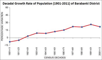
Decadal Growth Rate of Population (1901–2011) of Barabanki District
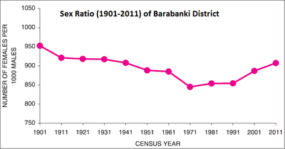
Sex Ratio (1901–2011) of Barabanki District
According to the 2011 census, Barabanki district had a population of 3,260,699. It then ranked 107th out of India’s 640 districts). The district had a population density of 740 inhabitants per square kilometre (1,900/sq mi). Its population growth rate over the decade 2001–2011 was 26.40%. Barabanki had a sex ratio of 887 females for every 1,000 males, and a literacy rate of 47.39%.
As per the report Provisional Population Totals Paper 1 of 2011 Uttar Pradesh Series 10 of the 2011 India Census, Barabanki district ranked 28th out of 71 districts of UP by population, with 1.63% of the state’s total. In 2001 census it ranked 32nd. Population density is ranked 46th, with an increase from 623 in 2001 to 739 in 2011. The district was 56th for literacy, with overall literacy rate of 63.76%. Indian census, 2011 in its Provisional Population Totals report for Uttar Pradesh gives following stat for the district:
| Total population | Males | Females | Percentage decadal growth 2001–2011 | Sex ratio | Density (persons per km2.) | Child population (0–6 years) | Child sex ratio (0–6 years) | Male literacy | Female literacy | Total literacy |
|---|---|---|---|---|---|---|---|---|---|---|
| 3,260,699 | 1,707,073 | 1,553,626 | 21.96 | 910 | 741 | 519,867 | 932 | 70.27 | 52.34 | 61.75 |
Annual Health Survey 2010-11 gave following stats for the district:
| Crude birth rate | Crude death rate | Natural growth rate | Infant mortality rate | Neo-natal mortality rate | Post neo-natal mortality rate | Under-five mortality rate | Sex ratio at birth ♀/♂ |
Sex ratio (0–4 years) ♀/♂ |
Sex ratio (all ages) ♀/♂ |
|
|---|---|---|---|---|---|---|---|---|---|---|
| Total | 26.0 | 7.6 | 18.4 | 71 | 55 | 16 | 95 | 930 | 922 | 893 |
| Urban | 26.4 | 7.7 | 18.7 | 72 | 57 | 15 | 97 | 936 | 933 | 896 |
| Rural | 21.1 | 6.1 | 15.0 | – | – | – | – | 838 | 780 | 857 |
As per Annual Health Survey 2010-11 district’s stats for wealth index were:
| Lowest (20%) | Highest (20%) | |
|---|---|---|
| Total | 33.8 | 7.1 |
| Urban | 35.2 | 4.9 |
| Rural | 10.3 | 42.9 |
| Year | Pop. | ±% p.a. |
|---|---|---|
| 1901 | 1,025,624 | — |
| 1911 | 942,608 | −0.84% |
| 1921 | 895,722 | −0.51% |
| 1931 | 925,401 | +0.33% |
| 1941 | 1,011,287 | +0.89% |
| 1951 | 1,099,754 | +0.84% |
| 1961 | 1,234,931 | +1.17% |
| 1971 | 1,424,536 | +1.44% |
| 1981 | 1,740,799 | +2.03% |
| 1991 | 2,112,782 | +1.96% |
| 2001 | 2,673,581 | +2.38% |
| 2011 | 3,260,699 | +2.01% |
| source: | ||
As per AHS 2010–11, the district’s effective literacy rate was 67.6 (rural 66.5, urban 80.9); for males it stood at 77.1 (rural 76.4, urban 85.8) and for females it was 56.9 (rural 55.3, urban 75.3).
1.518% of total population had some form of disability. Per 100,000 persons, the rate of severe injury was 188, major injury was 122, and minor injury was 423. Out of 100,000 persons, 691 were suffering from diarrhoea/dysentery, 966 were suffering from acute respiratory infection (ARI), 3,698 suffered from some kind of fever, 139 were suffering from diabetes, 418 were suffering from hypertension, 234 were suffering from tuberculosis, 578 were suffering from asthma/chronic respiratory diseases, and 801 were suffering from arthritis. 5,592 suffered from an acute illness. 98.3% of those suffering from acute illness received treatment (6.6% from a government source). 5,036 had symptoms of chronic illness, of which 83.1% sought medical care. 4,964 were suffering from any kind of chronic illness of which 45.5% received treatment (20.3% from a government source).
18.3% of population was having habit of chewing tobacco while 1.1% were in habit of chewing without tobacco. 15% of population smoked, and 4.2% drank alcohol.
Minorities comprised about 23% of the total population of the district. Barabanki is a category “A” district (i.e. having socio-economic and basic amenities parameters below the national average).