
New Mexico
is a state in the Southwestern United States. It is one of the Mountain States of the southern Rocky Mountains, sharing the Four Corners region of the western U.S. with Utah, Colorado, and Arizona, and bordering Texas to the east and southeast, Oklahoma to the northeast, and the Mexican states of Chihuahua and Sonora to the south. The state capital is Santa Fe, which is the oldest capital in the U.S., founded in 1610 as the government seat of Nuevo México in New Spain; the largest city is Albuquerque.
New Mexico is the fifth-largest of the fifty states, but with just over 2.1 million residents, ranks 36th in population and 46th in population density. Its climate and geography are highly varied, ranging from forested mountains to sparse deserts; the northern and eastern regions exhibit a colder alpine climate, while the west and south are warmer and more arid; the Rio Grande and its fertile valley runs from north-to-south, creating a riparian climate through the center of the state that supports a bosque habitat and distinct Albuquerque Basin climate. One–third of New Mexico’s land is federally owned, and the state hosts many protected wilderness areas and national monuments, including three UNESCO World Heritage Sites.
New Mexico’s economy is highly diversified, with major sectors including oil drilling, mineral extraction, dryland farming, cattle ranching, acequia and landrace agriculture, lumber, retail, scientific research laboratories, technological development, and the arts, especially textiles and visual arts. Its total gross domestic product (GDP) in 2020 was $95.73 billion, with a GDP per capita of roughly $46,300. State tax policy is characterized by low to moderate taxation of resident personal income by national standards, with tax credits, exemptions, and special considerations for military personnel and favorable industries; subsequently, its film industry is one of the largest and fastest growing in the country. Due to its large area and economic climate, New Mexico has a significant U.S. military presence, most notably the White Sands Missile Range, and many U.S. national security agencies base their research and testing arms in the state, such as the Sandia and Los Alamos National Laboratories, known as Project Y during the 1940s; here, the Manhattan Project was responsible for the world’s first atomic bomb and first nuclear test, Trinity.
In prehistoric times, New Mexico was home to Ancestral Puebloans, Mogollon, and the modern Comanche and Utes. Spanish explorers and settlers arrived in the 16th century, naming the territory Nuevo México after the Aztec Valley of Mexico, more than 250 years before the establishment and naming of the present-day country of Mexico; thus, the state did not derive its name from Mexico. Isolated by its rugged terrain and the relative dominance of its indigenous people, New Mexico was a peripheral part of the viceroyalty of New Spain. Following Mexican independence in 1821, it became an autonomous region of Mexico, though this autonomy was increasingly threatened by the centralizing policies of the Mexican government, culminating in the Revolt of 1837; at the same time, the region became more economically dependent on the United States. At the conclusion of the Mexican–American War in 1848, the U.S. annexed New Mexico as part of the larger New Mexico Territory. It played a central role in American westward expansion, and was admitted to the Union in 1912.
New Mexico’s history has contributed to its unique demographic and cultural character. One of only six majority-minority states, it has the nation’s highest percentage of Hispanic and Latino Americans and the second-highest percentage of Native Americans after Alaska. New Mexico is home to part of the Navajo Nation, 19 federally recognized Pueblo communities, and three different federally recognized Apache tribes. Its large Hispanic population includes Hispanos, who descend from early Spanish settlers, as well as Chicanos and Mexicans. The New Mexican flag, which is among the most recognizable in the U.S., reflects the state’s eclectic origins, bearing the scarlet and gold coloration of Spain’s Cross of Burgundy along with the ancient sun symbol of the Zia, a Puebloan tribe. The confluence of indigenous, Spanish, Mexican, Hispanic, and American influences is also evident in New Mexico’s unique cuisine, music genre, and architecture.
Etymology
New Mexico received its name long before the present-day nation of Mexico won independence from Spain and adopted that name in 1821. The name “Mexico” derives from Nahuatl and originally referred to the heartland of the Mexica (Aztec) Empire in the Valley of Mexico, far from the area of New Mexico.
Following their conquest of the Aztecs in the early 16th century, the Spanish began exploring what is now the western United States, using “Mexico” in 1563 to name the region of New Mexico (Spanish: Nuevo México). In 1581, the Chamuscado and Rodríguez Expedition named the region north of the Rio Grande San Felipe del Nuevo México. The Spaniards had hoped to find wealthy indigenous cultures similar to those of the Mexica’s in central Mexico. The indigenous cultures of New Mexico, however, proved to be unrelated to the Mexicas and lacking in riches, but the name persisted.
Before statehood in 1912, the name “New Mexico” loosely applied to various configurations of territories in the same general area, which evolved throughout the Spanish, Mexican, and American periods, but typically encompassed most of present-day New Mexico along with sections of neighboring states.
Geography

Wheeler Peak in the Sangre de Cristo Range

Puebloan ruins at Chaco Canyon
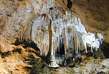
Carlsbad Caverns National Park

White Sands National Park
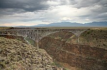
Rio Grande Gorge and Bridge

Shiprock
With a total area of 121,590 square miles (314,900 km2), New Mexico is the fifth-largest state, after Alaska, Texas, California, and Montana. Its eastern border lies along 103°W longitude with the state of Oklahoma, and 2.2 miles (3.5 kilometres) west of 103°W longitude with Texas (due to a 19th-century surveying error). On the southern border, Texas makes up the eastern two-thirds, while the Mexican states of Chihuahua and Sonora make up the western third, with Chihuahua making up about 90% of that. The western border with Arizona runs along the 109° 03’W longitude. The southwestern corner of the state is known as the Bootheel. The 37°N parallel forms the northern boundary with Colorado. The states of New Mexico, Colorado, Arizona, and Utah come together at the Four Corners in New Mexico’s northwestern corner. Its surface water area is about 292 square miles (760 km2).
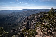
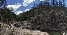
Despite its popular depiction as mostly arid desert, New Mexico has one of the most diverse landscapes of any U.S. state, ranging from wide, auburn-colored deserts and verdant grasslands, to broken mesas and high, snow-capped peaks. Close to a third of the state is covered in timberland, with heavily forested mountain wildernesses dominating the north. The Sangre de Cristo Mountains, the southernmost part of the Rocky Mountains, run roughly north–south along the east side of the Rio Grande, in the rugged, pastoral north. The Great Plains extend into the eastern third of the state, most notably the Llano Estacado (“Staked Plain”), whose westernmost boundary is marked by the Mescalero Ridge escarpment. The northwestern quadrant of New Mexico is dominated by the Colorado Plateau, characterized by unique volcanic formations, dry grasslands and shrublands, open pinyon-juniper woodland, and mountain forests. The Chihuahuan Desert, which is the largest in North America, extends through the south.
Over four–fifths of New Mexico is higher than 4,000 feet (1,250 meters) above sea level. The average elevation ranges from up to 8,000 feet (2,500 metes) above sea level in the northwest, to less than 4,000 feet in the southeast. The highest point is Wheeler Peak at over 13,160 feet (4,011 meters) in the Sangre de Cristo Mountains, while the lowest is the Red Bluff Reservoir at around 2,840 feet (866 meters), in the southeastern corner of the state.
In addition to the Rio Grande, which is tied for the fourth-longest river in the U.S., New Mexico has four other major river systems: the Pecos, Canadian, San Juan, and Gila. Nearly bisecting New Mexico from north to south, the Rio Grande has played an influential role in the region’s history; its fertile floodplain has supported human habitation since prehistoric times, and European settlers initially lived exclusively in its valleys and along its tributaries. The Pecos, which flows roughly parallel to the Rio Grande at its east, was a popular route for explorers, as was the Canadian River, which rises in the mountainous north and flows east across the arid plains. The San Juan and Gila lie west of the Continental Divide, in the northwest and southwest, respectively. With the exception of the Gila, all major rivers are dammed in New Mexico and provide a major water source for irrigation and flood control.
Aside from its rivers, New Mexico has few sizeable natural bodies of water; there are several artificial lakes and reservoirs, the largest being Elephant Butte Reservoir, which was created by the damming of the Rio Grande. At its height in the early 20th century, the reservoir was the largest man-made lake in the world.
Climate

Köppen climate types of New Mexico
New Mexico has long been reputable for its pleasant, temperate climate. Overall the state is semiarid to arid, with areas of continental and alpine climates at higher elevations. New Mexico’s statewide average precipitation is 12.9 inches (330 mm) a year, with average monthly amounts peaking in the summer, particularly in the more rugged north-central area around Albuquerque and in the south. Generally, the eastern third of the state receives the most rainfall, while the western third receives the least. Higher altitudes receive around 40 inches (1,000 mm), while the lowest elevations see as little as 8 to 10 inches (200–250 mm).
Annual temperatures can range from 65 °F (18 °C) in the southeast to below 40 °F (4 °C) in the northern mountains, with the average being the mid-50s °F (12 °C). During the summer, daytime temperatures can often exceed 100 °F (38 °C) at elevations below 5,000 feet (1,500 m); the average high temperature in July ranges from 99 °F (37 °C) at the lower elevations down to 78 °F (26 °C) at the higher elevations. In the colder months of November to March, many cities in New Mexico can have nighttime temperature lows in the teens above zero, or lower. The highest temperature recorded in New Mexico was 122 °F (50 °C) at the Waste Isolation Pilot Plant (WIPP) near Loving on June 27, 1994; the lowest recorded temperature is −50 °F (−46 °C) at Gavilan (near Lindrith) on February 1, 1951.
Due to the state’s stable climate, which provides for clearer skies, and relative isolation, which mitigates light pollution, there are several major astronomical observatories in New Mexico, including the Apache Point Observatory, the Very Large Array, the Magdalena Ridge Observatory, and others.
Flora and fauna

Greater roadrunner (the state bird of New Mexico)
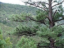
Owing to its varied topography, New Mexico has six distinct vegetation zones that provide diverse sets of habitats for many plants and animals. The Upper Sonoran Zone is by far the most prominent, constituting about three-fourths of the state; it includes most of the plains, foothills, and valleys above 4,500 feet, and is defined by prairie grasses, low piñon pines, and juniper shrubs. The Llano Estacado in the east features shortgrass prairie with blue grama, which sustain bison. The Chihuahuan Desert in the south is characterized by shrubby creosote. The Colorado Plateau in the northwest corner of New Mexico is high desert with cold winters, featuring sagebrush, shadescale, greasewood, and other plants adapted to the saline and seleniferous soil.
The mountainous north hosts a wide array of vegetation types corresponding to elevation gradients, such as piñon-juniper woodlands near the base, through evergreen conifers, spruce-fir and aspen forests in the transitionary zone, and Krummholz, and alpine tundra at the very top. The Apachian zone tucked into the southwestern bootheel of the state has high-calcium soil, oak woodlands, Arizona cypress, and other plants that are not found in other parts of the state. The southern sections of the Rio Grande and Pecos valleys have 20,000 square miles (52,000 square km) of New Mexico’s best grazing land and irrigated farmland.
New Mexico’s varied climate and vegetation zones consequently support diverse wildlife. Black bears, bighorn sheep, bobcats, cougars, deer, and elk, which live in habitats above 7,000 feet, while coyotes, jackrabbits, kangaroo rats, javelina, porcupines, pronghorn antelope, western diamondbacks, and wild turkeys live in less mountainous and elevated regions. The iconic roadrunner, which is the state bird, is abundant in the southeast. Endangered species include the Mexican gray wolf, which is being gradually reintroduced in the world, and Rio Grande silvery minnow.
Conservation
New Mexico and 12 other western states account for 93% of all federally owned land in the U.S. Roughly one–third of the state, or 24.7 million of 77.8 million acres, is held by the U.S. government, the tenth-highest percentage in the country. More than half this land is under the Bureau of Land Management, while another third managed by the U.S. Forest Service.
New Mexico was central to the early–20th century conservation movement, with Gila Wilderness being designated the world’s first wilderness area in 1924. The state also hosts nine of the country’s 84 national monuments, the most of any state after Arizona; these include the second oldest monument, El Morro, which was created in 1906, and the Gila Cliff Dwellings, proclaimed in 1907.
| Carson National Forest |
 |
| Cibola National Forest |
 |
| Lincoln National Forest |
 |
| Santa Fe National Forest |
 |
| Gila National Forest |
 |
| Gila Wilderness |
 |
Areas managed by the National Park Service include:
- Aztec Ruins National Monument at Aztec
- Bandelier National Monument in Los Alamos
- Capulin Volcano National Monument near Capulin
- Carlsbad Caverns National Park near Carlsbad
- Chaco Culture National Historical Park at Nageezi
- El Camino Real de Tierra Adentro National Historic Trail
- El Malpais National Monument in Grants
- El Morro National Monument in Ramah
- Fort Union National Monument at Watrous
- Gila Cliff Dwellings National Monument near Silver City
- Kasha-Katuwe Tent Rocks National Monument
- Old Spanish National Historic Trail
- Organ Mountains—Desert Peaks National Monument near Las Cruces
- Manhattan Project National Historical Park
- Pecos National Historical Park in Pecos
- Petroglyph National Monument near Albuquerque
- Salinas Pueblo Missions National Monument at Mountainair
- Santa Fe National Historic Trail
- White Sands National Park near Alamogordo
- Rio Grande del Norte National Monument near Taos
- Valles Caldera National Preserve in the Jemez Mountains
Areas managed by the New Mexico State Parks Division:
- Bluewater Lake State Park
- Bottomless Lakes State Park
- Brantley Lake State Park
- Cerrillos Hills State Park
- Caballo Lake State Park
- Cimarron Canyon State Park
- City of Rocks State Park
- Clayton Lake State Park
- Conchas Lake State Park
- Coyote Creek State Park
- Eagle Nest Lake State Park
- Elephant Butte Lake State Park
- El Vado Lake State Park
- Heron Lake State Park
- Hyde Memorial State Park
- Leasburg Dam State Park
- Living Desert Zoo and Gardens State Park
- Manzano Mountains State Park
- Mesilla Valley Bosque State Park
- Morphy Lake State Park
- Navajo Lake (Rio Arriba, NM and San Juan, NM)
- Oasis State Park
- Oliver Lee Memorial State Park
- Pancho Villa State Park
- Percha Dam State Park
- Rio Grande Nature Center State Park
- Rockhound State Park
- Santa Rosa Lake State Park
- Storrie Lake State Park
- Sugarite Canyon State Park
- Sumner Lake State Park
- Fenton Lake State Park
- Ute Lake State Park
- Vietnam Veterans Memorial State Park
- Villanueva State Park
Environmental issues
In January 2016, New Mexico sued the United States Environmental Protection Agency over negligence after the 2015 Gold King Mine waste water spill. The spill had caused heavy metals such as cadmium and lead and toxins such as arsenic to flow into the Animas River, polluting water basins of several states. The state has since implemented or considered stricter regulations and harsher penalties for spills associated with resource extraction.
New Mexico is a major producer of greenhouse gases. A study by Colorado State University showed that the state’s oil and gas industry generated 60 million metric tons of greenhouse gases in 2018, over four times greater than previously estimated. The fossil fuels sector accounted for over half the state’s overall emissions, which totaled 113.6 million metric tons, about 1.8% of the country’s total and more than twice the national average per capita. The New Mexico government has responded with efforts to regulate industrial emissions, promote renewable energy, and incentivize the use of electric vehicles.
History
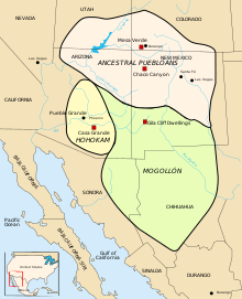
Ancestral Pueblo territory shown in pink over New Mexico
Prehistory
The first known inhabitants of New Mexico were members of the Clovis culture of Paleo-Indians.: 19 Later inhabitants include American Indians of the Mogollon and Ancestral Pueblo peoples cultures.: 52
Seven Cities of Cibola and Nuevo México
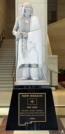
Statue of Popé, leader of the Pueblo Revolt. The statue, entitled Po’pay, is among two statues depicting New Mexicans at the United States Capitol National Statuary Hall Collection, the other being Dennis Chávez.
Francisco Vásquez de Coronado assembled an enormous expedition at Compostela in 1540–1542 to explore and find the mythical Seven Golden Cities of Cibola as described by Fray Marcos de Niza.: 19–24 The name New Mexico was first used by a seeker of gold mines named Francisco de Ibarra, who explored far to the north of New Spain in 1563 and reported his findings as being in “a New Mexico”. Juan de Oñate officially established the name when he was appointed the first governor of the new Province of New Mexico in 1598.: 36–37 The same year, he founded the San Juan de los Caballeros capital at San Gabriel de Yungue-Ouinge, the first permanent European settlement in New Mexico, on the Rio Grande near Ohkay Owingeh Pueblo.: 37 Oñate extended El Camino Real de Tierra Adentro, Royal Road of the Interior, by 700 miles (1,100 km) from Santa Bárbara, Chihuahua, to his remote colony.: 49
The settlement of La Villa Real de la Santa Fe de San Francisco de Asís was established as a more permanent capital at the foot of the Sangre de Cristo Mountains in 1610.: 182 As a result of the Pueblo Revolt, the only successful revolt against European expansion by Native Americans, these early cities were occupied by the Puebloan peoples until the Spanish returned with an offer of better cultural and religious liberties for the Pueblos.: 6, 48 After the death of the Pueblo leader Popé, Diego de Vargas restored the area to Spanish rule.: 68–75 The returning settlers founded La Villa de Alburquerque in 1706 at Old Town Albuquerque as a trading center for existing surrounding communities such as Barelas, Isleta, Los Ranchos, and Sandia,: 84 naming it for the viceroy of New Spain, Francisco Fernández de la Cueva, 10th Duke of Alburquerque.
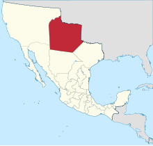
Territory of Santa Fe de Nuevo México when it belonged to Mexico in 1824
As a part of New Spain, the claims for the province of New Mexico passed to independent Mexico in 1821 following the Mexican War of Independence.: 109 The Republic of Texas claimed the portion east of the Rio Grande when it seceded from Mexico in 1836 when it incorrectly assumed the older Hispanic settlements of the upper Rio Grande were the same as the newly established Mexican settlements of Texas. Texas’s only attempt to establish a presence or control in the claimed territory was the failed Texan Santa Fe Expedition. Their entire army was captured and jailed by the Hispanic New Mexico militia.
At the turn of the 19th century, the extreme northeastern part of New Mexico, north of the Canadian River and east of the Sangre de Cristo Mountains was still claimed by France, which sold it in 1803 as part of the Louisiana Purchase. When the Louisiana Territory was admitted as a state in 1812, the U.S. reclassified it as part of the Missouri Territory. The region (along with territory that makes up present-day southeastern Colorado, the Texas and Oklahoma Panhandles, and southwestern Kansas) was ceded to Spain under the Adams-Onis Treaty in 1819.
By 1800, the population of New Mexico had reached 25,000.
Territorial phase
Following the victory of the United States in the Mexican–American War (1846–48), the Treaty of Guadalupe Hidalgo resulted in Mexico ceding its northern holdings to the U.S., including the territories of California, Texas, and New Mexico.: 132 The American government vowed to accept the residents’ claims to their lands and to accept them as full citizens with rights of suffrage.
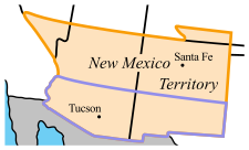
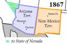
After Texas was admitted as a state in 1845, it continued to claim a northeastern portion of New Mexico east of the Rio Grande. Under the Compromise of 1850, it was forced by the U.S. government to drop these claims in exchange for $10 million in federal funds.: 135 Pursuant to the compromise, Congress established the separate New Mexico Territory in September of that year; it included most of present-day Arizona and New Mexico, along with the Las Vegas Valley and what would later become Clark County in Nevada.
In 1853, the U.S. acquired the mostly desert southwestern bootheel of the state, along with Arizona land south of the Gila River, in the Gadsden Purchase, which was needed for the right-of-way to encourage construction of a transcontinental railroad.: 136
When the U.S. Civil War broke out in 1861, both Confederate and Union governments claimed ownership and territorial rights over New Mexico Territory. The Confederacy claimed the southern tract as its own Arizona Territory, and as part of the Trans-Mississippi Theater of the war, waged the ambitious New Mexico Campaign to control the American Southwest and open up access to Union California. Confederate power in the New Mexico Territory was effectively broken after the Battle of Glorieta Pass in 1862. However, the Confederate territorial government continued to operate out of Texas, and Confederate troops marched under the Arizona flag until the end of the war. More than 8,000 men from New Mexico Territory served in the Union Army.
During the American frontier, many of the folklore characters of the Western genre had their origins in New Mexico, most notably businesswoman Maria Gertrudis Barceló, outlaw Billy the Kid, as well as lawmen Pat Garrett and Elfego Baca.
In the late 19th century, the majority of officially European-descended residents in New Mexico were ethnic mestizos of Native Mexican and Native American (Pueblo, Navajo, Apache, Genízaro, and Comanche) ancestry, many of whom had deep roots in the area from early Spanish colonial times, this distinctly New Mexican ethnic group became referred to as the Hispanos of New Mexico. Politically, they still controlled most of the town and county offices through area elections, and wealthy sheepherder families commanded considerable influence, preferring business, legislative, and judicial relations with fellow indigenous New Mexican groups. The Anglo Americans (which included recent African American arrivals) tended to have more ties to the territorial governor and judges, who were appointed by officials outside of the region. The Anglo minority was “outnumbered, but well-organized and growing”. These newly arrived settlers often tried to maintain New Mexico as a territory, since the governor was being assigned by the President of the United States, and they were worried about Native and Hispano communities being in positions of power. This mob mentality would sometimes culminate in the lynching of the Native, Hispanic, and Mexican peoples, as was attempted at the Frisco shootout. Prominent people attempted to fight this prejudice, including Vigil, Garrett, Otero, Curry, Larrazolo, Baca, Hagerman, and major constituents from both major political parties, the Democratic Party of New Mexico and the Republican Party of New Mexico.
Statehood

A Hispano boy in Chamisal, 1940.
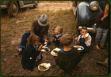
A homesteader and his children at the New Mexico Fair in Pie Town, New Mexico, 1940
The United States Congress admitted New Mexico as the 47th state on January 6, 1912.: 166 It had been eligible for statehood 60 years earlier but was delayed due to its majority of the population being “alien” (i.e. Mexican-American).
European-American settlers in the state had an uneasy relationship with the large Native American tribes, most of whose members lived on reservations at the beginning of the 20th century. Although Congress passed a law in 1924 that granted all Native Americans U.S. citizenship, as well as the right to vote in federal and state elections, New Mexico was among several states with Jim Crow laws, e.g. those who do not pay taxes cannot vote.
A major oil discovery in 1928 brought wealth to the state, especially Lea County and the town of Hobbs. The town was named after James Hobbs, a homesteader there in 1907. The Midwest State No. 1 well, begun in late 1927 with a standard cable-tool drilling rig, revealed the first signs of oil from the Hobbs field on June 13, 1928. Drilled to 4,330 feet and completed a few months later, the well-produced 700 barrels of oil per day on state land. The Midwest Refining Company’s Hobbs well-produced oil until 2002. The New Mexico Bureau of Mines and Mineral Resources called it “the most important single discovery of oil in New Mexico’s history”.
During World War II, the first atomic bombs were designed and manufactured at Los Alamos, a site developed by the federal government specifically to support a high-intensity scientific effort to rapidly complete research and testing of this weapon. The first bomb was tested at Trinity site in the desert between Socorro and Alamogordo on what is now White Sands Missile Range.: 179–180
| Historical population | |||
|---|---|---|---|
| Census | Pop. | %± | |
| 1850 | 61,547 | — | |
| 1860 | 93,516 | 51.9% | |
| 1870 | 91,874 | −1.8% | |
| 1880 | 119,565 | 30.1% | |
| 1890 | 160,282 | 34.1% | |
| 1900 | 195,310 | 21.9% | |
| 1910 | 327,301 | 67.6% | |
| 1920 | 360,350 | 10.1% | |
| 1930 | 423,317 | 17.5% | |
| 1940 | 531,818 | 25.6% | |
| 1950 | 681,187 | 28.1% | |
| 1960 | 951,023 | 39.6% | |
| 1970 | 1,016,000 | 6.8% | |
| 1980 | 1,302,894 | 28.2% | |
| 1990 | 1,515,069 | 16.3% | |
| 2000 | 1,819,046 | 20.1% | |
| 2010 | 2,059,179 | 13.2% | |
| 2020 | 2,117,522 | 2.8% | |
| Source: 1910–2020 | |||
Native Americans from New Mexico fought for the United States in both the First and Second World Wars. Veterans were disappointed to return and find their civil rights limited by state discrimination. In Arizona and New Mexico, veterans challenged state laws or practices prohibiting them from voting. In 1948, after veteran Miguel Trujillo, Sr. of Isleta Pueblo was told by the county registrar that he could not register to vote, he filed suit against the county in federal district court. A three-judge panel overturned as unconstitutional New Mexico’s provisions that Indians who did not pay taxes (and could not document if they had paid taxes) could not vote. Judge Phillips wrote:
Any other citizen, regardless of race, in the State of New Mexico who has not paid one cent of tax of any kind or character, if he possesses the other qualifications, may vote. An Indian, and only an Indian, in order to meet the qualifications to vote, must have paid a tax. How you can escape the conclusion that makes a requirement with respect to an Indian as a qualification to exercise the elective franchise and does not make that requirement with respect to the member of any race is beyond me.
New Mexico has received large amounts of federal government spending on major military and research institutions in the state. It is home to three Air Force bases, the White Sands Missile Range, and the federal research laboratories Los Alamos National Laboratory and Sandia National Laboratories. The state’s population grew rapidly after World War II, nearly doubling between 1940 and 1960; by 2000, residents numbered over 1.8 million from roughly 532,000 in 1940. While the high military presence brought considerable investment, it has also been the center of controversy; on May 22, 1957, a B-36 accidentally dropped a nuclear bomb 4.5 miles from the control tower while landing at Kirtland Air Force Base in Albuquerque; only its conventional “trigger” detonated.
In addition to federal personnel and agencies, many residents and businesses moved to state, particularly from the northeast, often drawn by its warm climate and low taxes. The pattern continues into the 21st century, with New Mexico adding over 400,000 residents between 2000 and 2020.
In the late 20th century, Native Americans were authorized by federal law to establish gaming casinos on their reservations under certain conditions, in states which had authorized such gaming. Such facilities have helped tribes close to population centers generate revenues for reinvestment in the economic development and welfare of their peoples.
In the 21st century, employment growth areas in New Mexico include electronic circuitry, scientific research, call centers, and Indian casinos.
Demographics
Population
The 2020 Census recorded a population of 2,117,522, an increase of 2.8% from 2,059,179 in the 2010 census. This was the lowest rate of growth in the western U.S. after Wyoming, and among the slowest nationwide. By comparison, between 2000 and 2010, New Mexico’s population increased by 11.7% from 1,819,046—among the fastest growth rates in the country. A report commissioned by the New Mexico Legislature attributed the slow growth to a negative net migration rate, particularly among those 18 or younger, and to a 19% decline in the birth rate. However, growth among the Hispanic and Native American communities remained healthy.
More than half of New Mexicans (51.4%) were born in the state; 37.9% were born in another state; 1.1% were born in either Puerto Rico, an island territory, or abroad to at least one American parent; and 9.4% were foreign born (compared to a national average of roughly 12%). Almost a quarter of the population (22.7%) was under the age of 18, and the state’s median age of 38.4 is slightly above the national average of 38.2. New Mexico’s somewhat older population is partly reflective of its popularity among retirees: It ranked as the most popular retirement destination in 2018, with an estimated 42% of new residents being retired.
Hispanics and Latinos constitute nearly half of all residents (49.3%), giving New Mexico the highest proportion of Hispanic ancestry among the fifty states. This broad classification includes descendants of Spanish colonists who settled between the 16th and 18th centuries as well as recent immigrants from Latin America (particularly Mexico and Central America).
From 2000 to 2010, the number of persons in poverty increased to 400,779, or approximately one-fifth of the population. The latest 2020 census recorded a slightly reduced poverty rate of 18.2%, albeit the third-highest among the U.S. states, compared to a national average of 10.5%. Poverty disproportionately affects minorities, with about one-third of African-Americans and Native Americans living in poverty, compared with less than a fifth of whites and roughly a tenth of Asians; likewise, New Mexico ranks 49th among states for education equality by race and 32nd for its racial gap in income.
New Mexico’s population is among the most difficult to count, according to the Center for Urban Research at the City University of New York. Challenges include the state’s size, sparse population, and numerous isolated communities. Likewise, the Census Bureau estimated that roughly 43% of the state’s population (about 900,000 people) live in such “hard-to-count” areas. In response, the New Mexico government invested heavily in public outreach to increase census participation, resulting in a final tally that exceeded earlier estimates and outperformed several neighboring states.
Birth data
The majority of live births in New Mexico are to non-Hispanic whites, with Hispanics of any race consistently accounting for well over half of all live births since 2013.
| Race | 2013 | 2014 | 2015 | 2016 | 2017 | 2018 | 2019 |
|---|---|---|---|---|---|---|---|
| White: | 21,325 (80.9%) | 21,161 (81.2%) | 21,183 (82.0%) | … | … | … | … |
| > Non-Hispanic White | 7,428 (28.2%) | 7,222 (27.7%) | 7,157 (27.7%) | 7,004 (28.4%) | 6,522 (27.4%) | 6,450 (28.0%) | 6,218 (27.1%) |
| American Indian | 3,763 (14.3%) | 3,581 (13.7%) | 3,452 (13.4%) | 2,827 (11.4%) | 2,694 (11.3%) | 2,603 (11.3%) | 2,643 (11.5%) |
| Asian | 597 (2.3%) | 578 (2.2%) | 517 (2.0%) | 425 (1.7%) | 420 (1.8%) | 409 (1.8%) | 392 (1.7%) |
| Black | 669 (2.5%) | 732 (2.8%) | 664 (2.6%) | 354 (1.4%) | 387 (1.6%) | 387 (1.7%) | 355 (1.5%) |
| Hispanic (of any race) | 14,402 (54.6%) | 14,449 (55.5%) | 14,431 (55.9%) | 13,639 (55.2%) | 13,362 (56.2%) | 12,783 (55.4%) | 12,924 (56.3%) |
| Total New Mexico | 26,354 (100%) | 26,052 (100%) | 25,816 (100%) | 24,692 (100%) | 23,767 (100%) | 23,039 (100%) | 22,960 (100%) |
Settlements

New Mexico population density map
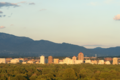
With just 17 people per square mile (6/km2), New Mexico is one of the least densely populated states, ranking 45th out of 50. By contrast, the overall population density of the U.S. is 90/mi2 (35.5/km2 ). The state is divided into 33 counties and 106 municipalities, which include cities, towns, villages, and a consolidated city-county, Los Alamos. Only two cities have at least 100,000 residents: Albuquerque and Las Cruces, whose respective metropolitan areas together account for the majority of New Mexico’s population.
Residents are concentrated in the north-central region of New Mexico, anchored by the state’s largest city, Albuquerque. Centered in Bernalillo County, the Albuquerque metropolitan area includes New Mexico’s third-largest city, Rio Rancho, and has a population of over 918,000, accounting for one-third of all New Mexicans. It is adjacent to Santa Fe, the capital and fourth-largest city. Altogether, the Albuquerque–Santa Fe–Las Vegas combined statistical area includes more than 1.17 million people, or nearly 60% of the state population.
New Mexico’s other major center of population is in south-central area around Las Cruces, its second-largest city and the largest city in both Doña Ana County and the southern region of the state. Its metropolitan area includes roughly 214,000 residents, but with neighboring El Paso, Texas forms a combined statistical area numbering over 1 million.
The state hosts 23 federally recognized tribal reservations, of which 11 hold off-reservation trust lands. The vast majority are concentrated in the northwest, followed by the north-central region.
Like several other southwestern states, New Mexico hosts numerous colonias along the Mexico-U.S. border, a type of unincorporated, low-income, slum. These areas are characterized by abject poverty, the absence of basic services such as water and sewage, and scarce housing and infrastructure. The University of New Mexico estimates there are 118 colonias in the state, though the U.S. Department of Housing and Urban Development identifies roughly 150.
|
Largest cities or towns in New Mexico Source:2017 U.S. Census Bureau Estimate
|
|||||||||
|---|---|---|---|---|---|---|---|---|---|
| Rank | Name | County | Pop. | ||||||
 Albuquerque 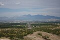 Las Cruces |
1 | Albuquerque | Bernalillo | 558,545 | 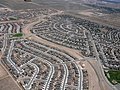 Rio Rancho  Santa Fe |
||||
| 2 | Las Cruces | Doña Ana | 101,712 | ||||||
| 3 | Rio Rancho | Sandoval / Bernalillo | 96,159 | ||||||
| 4 | Santa Fe | Santa Fe | 83,776 | ||||||
| 5 | Roswell | Chaves | 47,775 | ||||||
| 6 | Farmington | San Juan | 45,450 | ||||||
| 7 | Clovis | Curry | 38,962 | ||||||
| 8 | Hobbs | Lea | 37,764 | ||||||
| 9 | Alamogordo | Otero | 31,248 | ||||||
| 10 | Carlsbad | Eddy | 28,774 | ||||||
Race and ethnicity
New Mexico is one of six “majority-minority” states where non-Hispanic whites constitute less than half the population. As early as 1940, roughly half the population was estimated to be nonwhite.
According to the 2020 census, the majority of Hispanics in New Mexico claim descendance from Spanish colonists who settled between the 16th and 18th centuries, when the state was part of New Spain. Most remaining Hispanics are first and second generation immigrants from Mexico and Central America
New Mexico has the fourth largest Native American community in the U.S., at over 200,000. Comprising roughly one-tenth of all residents, this is the second largest population by percentage after Alaska. New Mexico is also the only state besides Alaska where indigenous people have maintained a stable proportion of the population for over a century: In 1890, Native Americans made up 9.4% of New Mexico’s population, roughly the same percentage as in 2020. By contrast, during that same period, neighboring Arizona went from one-third indigenous to less than 5%.
| Racial composition | 1970 | 1990 | 2000 | 2010 | 2020 |
|---|---|---|---|---|---|
| White: | 90.1% | 75.6% | 66.7% | 68.6% | 73.9% |
| > White alone, not Hispanic or Latino | – | – | – | – | 36.8% |
| Native | 7.2% | 8.9% | 9.5% | 9.4% | 9.5% |
| Black | 1.9% | 2.0% | 1.9% | 2.1% | 2.3% |
| Asian | 0.2% | 0.9% | 1.1% | 1.4% | 1.7% |
| Native Hawaiian and other Pacific Islander |
– | – | 0.1% | 0.1% | 0.2% |
| Other race | 0.6% | 12.6% | 17.0% | 15.0% | 9.0% |
| Two or more races | – | – | 3.6% | 3.7% | 2.6% |
| Hispanic or Latino, any race | – | – | – | – | 49.3% |
According to the 2000 United States Census,: 6 the most commonly claimed ancestry groups in New Mexico were:
- Mexican (16.3%)
- Native American (10.3%)
- German (9.8%)
- Spanish (9.3%)
- English (7.2%)
Census data from 2020 found that 1.5% of the population identifies as multiracial/mixed-race, a population larger than both the Asian and NHPI population groups.
Languages
| Languages Spoken in New Mexico | |
|---|---|
| English only | 64% |
| Spanish | 28% |
| Navajo | 4% |
| Others | 4% |
New Mexico ranks third after California and Texas in the number of multilingual residents. According to the 2010 U.S. Census, 28.45% of the population age 5 and older speak Spanish at home, while 3.50% speak Navajo. Some speakers of New Mexican Spanish are descendants of pre-18th century Spanish settlers. Contrary to popular belief, New Mexican Spanish is not an archaic form of 17th-century Castilian Spanish; though some archaic elements exists, linguistic research has determined that the dialect “is neither more Iberian nor more archaic” than other varieties spoken in the Americas. Nevertheless, centuries of isolation during the colonial period insulated the New Mexican dialect from “standard” Spanish, leading to the preservation of older vocabulary as well as its own innovations.
Besides Navajo, which is also spoken in Arizona, several other Native American languages are spoken by smaller groups in New Mexico, most of which are endemic to the state. Native New Mexican languages include Mescalero Apache, Jicarilla Apache, Tewa, Southern Tiwa, Northern Tiwa, Towa, Keres (Eastern and Western), and Zuni. Mescalero and Jicarilla Apache are closely related Southern Athabaskan languages, and both are also related to Navajo. Tewa, the Tiwa languages, and Towa belong to the Kiowa-Tanoan language family, and thus all descend from a common ancestor. Keres and Zuni are language isolates with no relatives outside of New Mexico.
Official language
New Mexico’s original state constitution of 1911 required all laws be published in both English and Spanish for twenty years after ratification; this requirement was renewed in 1931 and 1943, with some sources stating the state was officially bilingual until 1953. Nonetheless, the constitution does not declare any language “official”. While Spanish was permitted in the legislature until 1935, all state officials are required to have a good knowledge of English; consequently, some analysts argue that New Mexico cannot be considered a bilingual state, since not all laws are published in both languages.
However, the state legislature remains constitutionally empowered to publish laws in English and Spanish, and to appropriate funds for translation. Amendments to the New Mexico constitution must be approved by referendum printed on the ballot in both English and Spanish. Certain legal notices must be published in English and Spanish, and the state maintains a list of newspapers for Spanish publication.
With regard to the judiciary, witnesses and defendants have the right to testify in either of the two languages, and monolingual speakers of Spanish have the same right to be considered for jury duty as do speakers of English. In public education, the state has the constitutional obligation to provide bilingual education and Spanish-speaking instructors in school districts where the majority of students are Hispanophone. The constitution also provides that all state citizens who speak neither English nor Spanish have a right to vote, hold public office office, and serve on juries.
In 1989, New Mexico became the first of only four states to officially adopt the English Plus resolution, which supports acceptance of non-English languages. In 1995, the state adopted an official bilingual song, “New Mexico – Mi Lindo Nuevo México”.: 75, 81 In 2008, New Mexico was the first to officially adopt a Navajo textbook for use in public schools.
Religion

San Miguel Chapel, built in 1610 in Santa Fe, is the oldest church structure in the continental U.S.