
Kadapa district (officially: YSR District formerly: Cuddapah: 19 ) is one of the thirteen districts in the Indian state of Andhra Pradesh. It is also one of the four districts in the Rayalaseema region of the state. Kadapa is the seat of administration for the district. The district was renamed as YSR District in honour of Y. S. Rajasekhara Reddy, commemorating former Chief Minister of combined Andhra Pradesh.
History
Rock paintings
Paleolithic rock paintings found at Chintakunta caves near Muddanuru in Kadapa district are said to be the second largest group of paintings in India after Bhimbetika rock art paintings. The rock paintings with mystic figures are also found at Dappalle village near Mylavaram Dam in Jammalamadugu Taluk of the district.
Prehistoric culture
Many Paleolithic sites were found in Kadapa district, as the surroundings of Jammalamadugu, Mailavaram Dam and Gandikota.
Some megalithic burial sites were explored near Porumamilla, Sankhavaram and at Yellatur village near Kadapa. The surroundings of Vontimitta are also noted as Megalithic cultural sites.
The section of Rayachoti consists of many documented and undocumented Megalithic sites and stone circles. A noted megalithic site is at Devandlapalli in Tsundupalle taluk of the district.
Buddhism & Jainism
Kadapa has historical importance since BC era. It was ruled by the Mauryan Empire and the Satavahana Empire (Andhras). Buddhism must have flourished here for many years along the banks of rivers Cheyyeru and Penna. Nandalur is an important Buddhist site in the district along with Tallapaka, Rajampeta, Konduru, Khazipeta in the district. Jainism also had a place in Kadapa district history; the remnants of a buried Jain temple were found at Danavulapadu village on the banks of river Penna.
Medieval history

Gandikota fort view
It was part of the area ceded to the British by Nizam. The district was formed by splitting the ceded districts into two in 1808 during the British rule, the other district being Bellary. The British spelt the district as Cuddapah.
The district is part of Rayalaseema, commemorating the name of Rayulu (Kings) of the Vijayanagar Empire, who ruled the area in the 16th century. Gandikota fort located on the bank of the Penna river was the citadel of Pemmasani Nayaks, commanders of Vijayanagar army and who won the battles of Raichur and Gulbarga for the Vijayanagar kings.
The old records of the district reveal that Kadapa previously called Gadapa which translated in Telugu to threshold. The ancient village of Kadapa with its large tank and temple of Lord Venkateswara at Devuni Kadapa was convenient camping place for the myriads of pilgrims travelling to the holy shrine of Tirupathi. There was a belief that the pilgrims have to first visit Devuni Kadapa, before going to Tirupathi to pray to Saint Annamacharya and Saint Potuluri Veera Brahmam who foretold the future and advocated a classless society. The ancient temple at Vontimitta which inspired Pothana to compose Andhra Maha Bhagavatham is also in the district. In the olden days Kadapa was also called “Hiranyanagaram”.
Recent historical records reveal that in Jyothi village located in Siddavatam mandal has 108 Shiva lingas on the bank of Penna river.
Modern history
After the Treaty of Seringapatam, Nizam of Hyderabad acquired the district. He ceded it to the British in 1800 and eight years later they created the present-day administrative entity. The district headquarters were situated in Siddavatam but moved to Kadapa in 1812.
Geography

Districts of Andhra Pradesh
Kadapa district occupies an area of 15,938 square kilometres (6,154 sq mi), comparatively equivalent to Canada’s Prince Patrick Island. The main rivers in this district are Penna, Chitravathi, Kunderu, Papagni, Sagileru, Bahuda and Cheyyeru.
Reservoirs

Brahmam Sagar reservoir
Kadapa district has several reservoirs, some of which are Brahmamsagar Reservoir, Mylavaram Dam Reservoir, Annamayya Project, Gandikota Reservoir.
Volcanogenic bedded Barytes
Volcanogenic bedded Barytes located at Mangampet in Obulavaripalle mandal has been declared the National Geological Monuments of India by the Geological Survey of India (GSI), for their protection, maintenance, promotion and enhancement of geotourism.
Demographics
| hidePopulation Growth of Kadapa district | |||
|---|---|---|---|
| Census | Population | %± | |
| 1871 | 1,351,194 |
—
|
|
| 1881 | 1,121,038 | −17.0% | |
| 1891 | 1,272,072 | 13.5% | |
| 1901 | 1,291,267 | 1.5% | |
| 2001 | 2,601,797 |
—
|
|
| 2011 | 2,884,524 | 10.9% | |
| source:1871-1901 | |||
As of 2011 census, Kadapa district has a population of 2,884,524. This gives it a ranking of 132nd in India (out of a total of 640). The district has a population density of 188 inhabitants per square kilometre (490/sq mi) . Its population growth rate over the decade 2001–2011 was 10.87%. It has a sex ratio of 984 females for every 1000 males, and a literacy rate of 67.88%.
Economy
Besides its historical importance, the district has occupied an important place in the industrial map of Andhra Pradesh with its valuable mineral resources.
The Gross District Domestic Product (GDDP) of the district is ₹26,342 crore (US$3.5 billion) and contributes 5% to the Gross State Domestic Product (GSDP). For the FY 2013–14, the per capita income at current prices was ₹70,821 (US$940). The primary, secondary and tertiary sectors of the district contribute ₹6,204 crore (US$820 million), ₹6,935 crore (US$920 million) and ₹13,203 crore (US$1.8 billion) respectively.
Black corson soil lands are 24%, black soil 19%, sandy soil lands 4%, red soil lands 25%. The first variety lands are very fertile, sand soil lands less so. ‘Korra’, orange, lime and betel leaf are the special crops. They are cultivated near river beds. Starting at Sunkesula Dam on Tungabadra river K. C. Canal flows through Kadapa and Kurnool districts providing water to 40 km2 (15 sq mi) of cultivable land. The main source of drinking water to this district is Galeru Nagari Sujala Sravanthi Project Canal.
This district is the repository of mineral wealth. As per the 1983 survey of geological survey of India 3 million tons of lead, 74,000,000 tons of barytes, and 27000 tons of asbestos deposits are there. It is estimated that 70 million tons of barytes deposits might be in Mangampet. There are clay deposits in Rajampet. This is used to make stone implements. Limestone is available in Yerraguntla. National Mineral Development Corporation is extracting asbestos in Brahman palli and barytes in Mangampet. Kadapa is also famous for its stone called “kadapa stone” used in building construction and for slabs especially in south India. In Tummalapalle, there are 49,000 tonnes of confirmed uranium deposits which are mined and processed locally. Apart from these minerals and industries Agriculture also forms a part district economy.
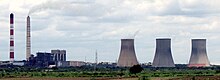
Rayalaseema Thermal Power Station
Industries
In 2006 the Indian government named Kadapa district as one of the country’s 250 most backward districts (out of a total of 640). It is one of the thirteen districts in Andhra Pradesh currently receiving funds from the Backward Regions Grant Fund Programme (BRGF).
Administration
The present district collector is Ch. Hari Kiran.
Divisions

Kadapa district Collectorate Complex
Kadapa district has three Revenue Divisions viz., Kadapa, Rajampeta and Jammalamadugu divisions. The district has 51 mandals under these revenue divisions. It also has a Municipal Corporation of Kadapa and seven municipalities namely Badvel, Mydukur, Proddatur, Pulivendula, Rayachoti, Jammalamadugu, Rajampet.
Mandals
The mandals are listed with respect to their revenue divisions in the following table:
| # | Kadapa Division | Rajampeta Division | Jammalamadugu Division |
|---|---|---|---|
| 1 | Chakrayapet | Atlur | Chapadu |
| 2 | Chennur | B Matham | Duvvur |
| 3 | Chinnamandem | B.Kodur | Jammalamadugu |
| 4 | Chinthakommadinne | Badvel | Kondapuram |
| 5 | Kadapa | Chitvel | Lingala |
| 6 | Galiveedu | Gopavaram | Muddanur |
| 7 | Kamalapuram | Kalasapadu | Mydukur |
| 8 | Khajipet | Kodur | Mylavaram |
| 9 | Lakkireddipalle | Nandalur | Peddamudium |
| 10 | Pendlimarri | Obulavaripalle | Proddatur |
| 11 | Ramapuram | Penagalur | Pulivendula |
| 12 | Rayachoti | Porumamilla | Rajupalem |
| 13 | Sambepalle | Pullampeta | Simhadripuram |
| 14 | T Sundupalle | Rajampet | Thondur |
| 15 | Vallur | Siddavatam | Vempalle |
| 16 | Veeraballi | Sri Avadhuth Kasinayana | Vemula |
| 17 | Veerapunayunipalle | Vontimitta | |
| 18 | Yerraguntla |
Before the formation of mandals, Administration was done through Taluka system.
Erstwhile Talukas in Kadapa district were
| S.No. | Erstwhile Talukas in 1971 | Newly Formed Talukas in 1978 | New Mandals formed in 1985 |
|---|---|---|---|
| 1. | Kadapa | Kadapa | Kadapa, Vallur, Chennur, Khajipeta, Chinthakommadinne, Pendlimarri, |
| 2 | Kamalapuram | Kamalapuram | Kamalapuram, Yerraguntla, Veerapunayunipalle |
| 3 | Jammalamadugu | Jammalamadugu | Jammalamadugu , Mylavaram, Peddamudium |
| Muddanur | Muddanur, Kondapuram, Jammalamadugu | ||
| 4 | Proddutur | Proddutur | Proddutur, Mydukur, Chapad, Rajupalem, Duvvur, |
| 5 | Badvel | Badvel | Badvel, Kalasapadu, Sri Avadutha kasinayana, Porumamilla, B.Kodur, Brahmamgari mattam, Gopavaram |
| 6 | Sidhout | Sidhout | Sidhout, Atlur, Gopavaram, Vontimitta, Gopavaram |
| 7 | Rajampeta | Rajampeta | Rajampeta, Nandalur, Penagalur |
| Kodur | Kodur, Pullampeta, Chitvel, Obulavaripalle, | ||
| 8 | Rayachoty | Rayachoty | Rayachoty, Veeraballe, Sambepalle, Chinnamandem, T sundupalle |
| Lakkireddipalli | Lakkireddipalle, Chakrayapeta, Ramapuram, Galiveedu | ||
| 9 | Pulivendula | Pulivendula | Pulivendula, Vempalle, Lingala, Thondur, Simhadripuram, Vemula |
Assembly constituencies
- Badvel
- Jammalamadugu
- Kadapa
- Kamalapuram
- Railway Koduru (SC)
- Mydukur
- Rajampet
- Rayachoti
- Proddatur
- Pulivendula
Towns in Kadapa District
|
Largest cities or towns in Kadapa District As per the 2011 Census
|
|||||||||
|---|---|---|---|---|---|---|---|---|---|
| Rank | Division | Pop. | |||||||
 Kadapa  Proddatur |
1 | Kadapa | Kadapa Division | 344,893 |  Rayachoti  Badvel |
||||
| 2 | Proddatur | Jammalamadugu Division | 194,850 | ||||||
| 3 | Rayachoti | Kadapa Division | 98,299 | ||||||
| 4 | Badvel | Rajampeta Division | 70,626 | ||||||
| 5 | Pulivendula | Jammalamadugu Division | 65,706 | ||||||
| 6 | Jammalamadugu | Jammalamadugu Division | 61,218 | ||||||
| 7 | Rajampeta | Rajampeta Division | 54,050 | ||||||
| 8 | Mydukur | Jammalamadugu Division | 45,790 | ||||||
| 9 | Railway Kodur | Rajampeta Division | 39,408 | ||||||
| 10 | Yerraguntla | Kadapa Division | 32,574 | ||||||
The Population of Towns in Kadapa district is as follows
| S.No. | Town Name | Civic Status of Town | MunicipalityFormation
Year |
No. ofWards | 2011 CensusPopulation | 2001 CensusPopulation | 1991 CensusPopulation | 1981 CensusPopulation | 1971 CensusPopulation |
|---|---|---|---|---|---|---|---|---|---|
| 1. | Kadapa | Municipal Corporation | 1868 | 50 | 344,893 | 278,039 | 215,866 | 103,125 | 66,195 |
| 2 | Proddutur | Municipality Special Grade | 1915 | 41 | 194,850 | 165,216 | 133,914 | 107,070 | 70,822 |
| 3 | Rayachoty | Municipality Grade-1 | 2005 | 34 | 98,299 | 72,297 | 51,931 | 35,257 | 16,721 |
| 4 | Badvel | Municipality Grade-2 | 2006 | 35 | 70,626 | 47,954 | 13,679 | 11,460 | 9,083 |
| 5 | Pulivendula | Municipality Grade-2 | 2005 | 33 | 65,706 | 38,566 | 28,317 | 21,104 | 11,704 |
| 6 | Jammalamadugu | Nagar Panchayat | 2005 | 20 | 61,218 | 54,218 | 46,133 | 33,729 | 20,008 |
| 7 | Rajampeta | Municipality Grade-2 | 2005 | 29 | 54,050 | 45,957 | 26,181 | 19,927 | 13,345 |
| 8 | Mydukur | Municipality Grade-3 | 2011 | 24 | 45,790 | 31,838 | 24,222 | 16,405 | 10,982 |
| 9 | Yerraguntla | Nagar Panchayat | 2012 | 20 | 32,574 | 26,838 | 19,361 | 11,784 | 6,191 |
| 10 | Kamalapuram | Nagar Panchayat | 2020 | 20 | 20,623 | 17,540 | 12,364 | 9,873 | 8,443 |
| S.No. | Town | Civic status of Town | 2011 CensusPopulation |
|---|---|---|---|
| 1. | Railway Kodur | Census Town | 39,408 |
| 2 | Lakkireddipalli | Grama Panchayat | 10,303 |
| 3 | Muddanur | Census Town | 9,775 |
| 4 | Sidhout | Grama Panchayat | 4,787 |
| S.No. | Town | Civic Status of Towns | 2011 CensusPopulation |
|---|---|---|---|
| 1 | Nagireddipalle | Census Town | 12,318 |
| 2 | Veparala | Census Town | 6,712 |
| 3 | Mangampeta | Census Town | 5,175 |
Transport
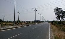
Pulivendula-Kadapa 4 lane road near pulivendula
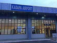
Kadapa Airport Terminal
Kadapa district is well-connected by road, rail and airways with neighbouring districts of Andhra Pradesh.
Roadways
The total road length of state highways in the district is 1,088 km (676 mi). National Highway 40, National Highway 716 and National Highway 67 pass through the district.
Railways
The district has railway administration under Guntakal railway division. Kadapa, Rajampet, Yerraguntla Junction, Proddatur, Jammalamadugu are some of the main railway stations in the district.
Airways
Kadapa Airport is located north west to Kadapa city.
Education

JNTUACEP Entrance, Pulivendula

RIMS Medical College Block, Kadapa
The primary and secondary school education is imparted by government, aided and private schools, under the School Education Department of the state. As per the school information report for the academic year 2015–16, there are a total of 4,488 schools. They include, 22 government, 3,094 mandal and zilla parishads, 1 residential, 1,181 private, 10 model, 29 Kasturba Gandhi Balika Vidyalaya (KGBV), 88 municipal and 63 other types of schools. The total number of students enrolled in primary, upper primary and high schools of the district are 416,782.
There are junior colleges for (10+2) education, among which 25 are under government, 13 are social welfare, 26 private aided, 83 are private unaided and also there are a few incentive, co-operative, government model colleges. For the purpose of imparting and the students sit for the certificate of Board of Intermediate Education. The government colleges of Kadapa, Proddatur, Pulivendula, Rayachoti, Jammalamadugu, and Rajampet are the oldest government colleges of the district, established in 1969.
The higher education colleges have various fields of study like medical, nursing, degree, post graduate, polytechnic, law, teaching, pharmacy, engineering, veterinary, etc. The Yogi Vemana University is a state university which has one autonomous college as per the Universities Grant Commission. Sri Venkateswara College of Veterinary Sciences. The engineering colleges of the district are, KSRM College of Engineering, Annamacharya Institute of Technology and Sciences, etc.