
The Dnieper (/(də)ˈniːpər/ (də-)NEE-pər) or Dnipro (/(də)niːˈproʊ/ (də-)nee-PROH; Ukrainian: Дніпро (![]() listen)) is one of the major rivers of Europe, rising in the Valdai Hills near Smolensk, Russia, before flowing through Belarus and Ukraine to the Black Sea. It is the longest river of Ukraine and Belarus and the fourth-longest river in Europe, after the Volga, Danube, and Ural rivers. The total length is approximately 2,200 km (1,400 mi) with a drainage basin of 504,000 square kilometres (195,000 sq mi). Historically, the river was an important barrier, dividing Ukraine into right and left banks. Today, the river is noted for its dams and hydroelectric stations. The Dnieper is an important navigable waterway for the economy of Ukraine and is connected via the Dnieper–Bug Canal to other waterways in Europe.
listen)) is one of the major rivers of Europe, rising in the Valdai Hills near Smolensk, Russia, before flowing through Belarus and Ukraine to the Black Sea. It is the longest river of Ukraine and Belarus and the fourth-longest river in Europe, after the Volga, Danube, and Ural rivers. The total length is approximately 2,200 km (1,400 mi) with a drainage basin of 504,000 square kilometres (195,000 sq mi). Historically, the river was an important barrier, dividing Ukraine into right and left banks. Today, the river is noted for its dams and hydroelectric stations. The Dnieper is an important navigable waterway for the economy of Ukraine and is connected via the Dnieper–Bug Canal to other waterways in Europe.
In antiquity, the river was known to the Greeks as the Borysthenes and was part of the ancient Amber Road trade route.
| Dnieper | |
|---|---|
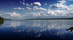
The Dnieper River in Dnipropetrovsk Oblast, Ukraine
|
|
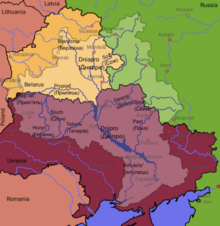
Dnieper River drainage basin
|
|
| Native name |
|
| Location | |
| Countries |
|
| Cities |
|
| Physical characteristics | |
| Source | |
| • location | Valdai Hills, Russia |
| • coordinates | 55°52′18.08″N 33°43′27.08″E |
| • elevation | 220 m (720 ft) |
| Mouth | Dnieper Delta |
|
• location
|
Ukraine |
|
• coordinates
|
46°30′00″N 32°20′00″ECoordinates: 46°30′00″N 32°20′00″E |
|
• elevation
|
0 m (0 ft) |
| Length | 2,201 km (1,368 mi) |
| Basin size | 504,000 km2 (195,000 sq mi) |
| Discharge | |
| • location | Kherson |
| • average | 1,670 m3/s (59,000 cu ft/s) |
| Basin features | |
| Tributaries | |
| • left | Sozh, Desna, Trubizh, Supiy, Sula, Psel, Vorskla, Samara, Konka, Bilozerka |
| • right | Drut, Berezina, Prypiat, Teteriv, Irpin, Stuhna, Ros, Tiasmyn, Bazavluk, Inhulets |
| Protection status | |
|
Ramsar Wetland
|
|
| Official name | Dnieper River Floodplain |
| Designated | 29 May 2014 |
| Reference no. | 2244 |

Contents
- 1Etymology and name in various languages
- 1.1Names in local languages
- 1.2Other names
- 2Geography
- 2.1Tributaries of the Dnieper
- 2.2Rapids
- 2.3Canals
- 2.4Fauna
- 2.5Estuary
- 3Ecology
- 4Navigation
- 5Reservoirs and hydroelectric power
- 6Regions and cities
- 6.1Regions
- 6.2Cities
- 7In the arts
- 7.1Literature
- 7.2Visual arts
- 7.3Films
- 7.4Music
- 8Image gallery
- 8.1Popular culture
- 9See also
- 10References and footnotes
- 11External links
Etymology and name in various languages

Human representation of the Dnieper river (known as Borysthenes) on an Ancient Greek coin of Pontic Olbia, 4th–3rd century BC
The name Dnieper may be derived either from Sarmatian Dānu apara “the river on the far side” or from Scythian Dānu apr (Dānapr) “deep river”. By way of contrast, the name Dniester either derives from “the close river” or from a combination of Scythian Dānu (river) and Ister, the Thracian name for the Dniester.
Names in local languages
In the languages of the three countries it flows through it has essentially the same name, albeit with different pronunciations:
- Russian: Днепр, tr. Dnepr, IPA: ; formerly spelled Днѣпръ;
- Belarusian: Дняпро, romanized: Dnyapro, , or Днепр Dnyepr, ;
- Ukrainian: Дніпро, romanized: Dnipro, IPA: (
 listen); poetic Дніпр, Dnipr; formerly Дніпер Dniper, , or older Днѣпръ (Dnipr, ).
Other names
Pre-1918 photo with the old spelling of Dnieper (Днѣпръ)
- Classical Greek authors, including Herodotus, called it ΒορυσθένηςIn Latin it was Borysthenes, derived from the Greek, while the poet Ovid used the adjectival form Boristhenius substantively as a name for the river.
- Late Greek and Late Latin authors called it Greek: Δάναπρις (Latin: Danapris)or Danaper
- Old East Slavic name used at the time of Kievan Rus’ was Slavuta or Slavutych
- The Huns called it Var,
- Bulgars – Buri-Chai.
- Its former name in the Tatar language is Üze, from Kipchak Uzeu.
- The name in Crimean Tatar: Özü, hence Ochakiv (formerly Özü-cale, Dnieper fortress)
- In Romanian, it is called Nipru.
- In Turkish Özi or Özü.
Geography
The total length of the river is variously given as 2,145 kilometres (1,333 mi) or 2,201 km (1,368 mi), of which 485 km (301 mi) are within Russia, 700 km (430 mi) are within Belarus, and 1,095 km (680 mi) are within Ukraine. Its basin covers 504,000 square kilometres (195,000 sq mi), of which 289,000 km2 (112,000 sq mi) are within Ukraine, 118,360 km2 (45,700 sq mi) are within Belarus.
The source of the Dnieper is the sedge bogs (Akseninsky Mokh) of the Valdai Hills in central Russia, at an elevation of 220 m (720 ft). For 115 km (71 mi) of its length, it serves as the border between Belarus and Ukraine. Its estuary, or liman, used to be defended by the strong fortress of Ochakiv.
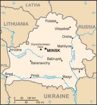
The southernmost point in Belarus is on the Dnieper to the south of Kamaryn in Brahin Raion.
Tributaries of the Dnieper
Belarus section of the Dnieper river
The Dnieper has many tributaries (up to 32,000) with 89 being rivers of 100+ km. The main ones are, from its source to its mouth:

Dnieper basin showing peoples in the ninth century
- Vyazma (L)
- Vop (R)
- Khmost (R)
- Myareya (L)
- Drut (R)
- Berezina (R)
- Sozh (L)
- Prypiat (R)
- Teteriv (R)
- Irpin (R)
- Desna (L)
- Stuhna (R)
- Trubizh (L)
- Ros (R)
- Tiasmyn (R)
- Supiy (L)
- Sula (L)
- Psyol (L)
- Vorskla (L)
- Oril (L)
- Samara (L)
- Konka (L)
- Bilozerka (L)
- Bazavluk (R)
- Inhulets (R)
Many small direct tributaries also exist, such as, in the Kyiv area, the Syrets (right bank) in the north of the city, the historically significant Lybid (right bank) passing west of the centre, and the Borshahivka (right bank) to the south.
The water resources of the Dnieper basin compose around 80% out of all Ukraine.
Rapids
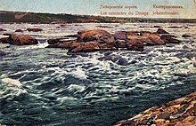
Rapids at Dnieper in 1915

Tractus Borysthenis or Dnieper (from Bovzin city to Chortyca island) in 1662
Dnieper Rapids were part of trade route from the Varangians to the Greeks, first mentioned in the Kyiv Chronicle. The route was probably established in the late eighth and early ninth centuries and gained significant importance from the tenth until the first third of the eleventh century. On the Dnieper the Varangians had to portage their ships round seven rapids, where they had to be on guard for Pecheneg nomads.
Along this middle flow of the Dnieper, there were 9 major rapids (although some sources cite a fewer number of them), obstructing almost the whole width of the river, about 30 to 40 smaller rapids, obstructing only part of the river, and about 60 islands and islets.
After the Dnieper hydroelectric station was built in 1932, they were inundated by Dnieper Reservoir.
Canals
There are a number of canals connected to the Dnieper:
- The Dnieper–Donbas Canal;
- The Dnieper–Kryvyi Rih Canal;
- The Kakhovka Canal (southeast of the Kherson region);
- The Krasnoznamianka Irrigation System in the southwest of the Kherson region;
- The North Crimean Canal—will largely solve the water problem of the peninsula, especially in the arid northern and eastern Crimea;
- The Inhulets Irrigation System.
Fauna
The river is part of the quagga mussel’s native range. The mussel has been accidentally introduced around the world, where it has become an invasive species.
Estuary

Satellite images of the Dnieper estuary, captured 8 August 2015
The city of Kherson is nearest to the Dnieper estuary. It has no large port facilities.
Ecology
Nowadays the Dnieper River suffers from anthropogenic influence and obtain numerous emissions of pollutants. The Dnieper is close to the Prydniprovsky Chemical Plant radioactive dumps (near Kamianske) and susceptible to leakage of its radioactive waste. The river is also close to the Chernobyl Nuclear Power Station (Chernobyl Exclusion Zone) that is located next to the mouth of the Prypiat River.
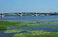
Almost 2,000 km (1,200 mi) of the river is navigable (to the city of Dorogobuzh). The Dnieper is important for transportion in the economy of Ukraine: Its reservoirs have large ship locks, allowing vessels of up to 270 by 18 metres (886 ft × 59 ft) access as far as the port of Kyiv, and thus are an important transportation corridor. The river is used by passenger vessels as well. Inland cruises on the rivers Danube and Dnieper have had a growing market in recent decades.
Upstream from Kyiv, the Dnieper receives the water of the Pripyat River. This navigable river connects to the Dnieper-Bug canal, the link with the Bug River. Historically, a connection with the Western European waterways was possible, but a weir without any ship lock near the town of Brest, Belarus, has interrupted this international waterway. Poor political relations between Western Europe and Belarus mean there is little likelihood of reopening this waterway in the near future. River navigation is interrupted each year by freezing and severe winter storms.
Reservoirs and hydroelectric power

From the mouth of the Prypiat River to the Kakhovka Hydroelectric Station, there are six sets of dams and hydroelectric stations, which produce 10% of Ukraine’s electricity.
The first constructed was the Dnieper Hydroelectric Station (or DniproHES) near Zaporizhzhia, built between 1927 and 1932 with an output of 558 MW. It was destroyed during World War II, but was rebuilt in 1948 with an output of 750 MW.
| Location | Dam | Reservoir area | Hydroelection station | Date of construction |
|---|---|---|---|---|
| Kyiv | Kyiv Reservoir | 922 km2 or 356 sq mi | Kyiv Hydroelectric Station | 1960–1964 |
| Kaniv | Kaniv Reservoir | 675 km2 or 261 sq mi | Kaniv Hydroelectric Station | 1963–1975 |
| Kremenchuk | Kremenchuk Reservoir | 2,250 km2 or 870 sq mi | Kremenchuk Hydroelectric Station | 1954–1960 |
| Kamianske | Kamianske Reservoir | 567 km2 or 219 sq mi | Middle Dnieper Hydroelectric Power Plant | 1956–1964 |
| Zaporizhzhia | Dnieper Reservoir | 420 km2 or 160 sq mi | Dnieper Hydroelectric Station | 1927–1932; 1948 |
| Kakhovka | Kakhovka Reservoir | 2,155 km2 or 832 sq mi | Kakhovka Hydroelectric Station | 1950–1956 |
Regions and cities

Satellite image of the Dnieper and its tributaries
Regions
|
|
|
- The Dnieper River in different regions
-
The Dnieper River in Kyiv, Ukraine
-
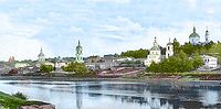
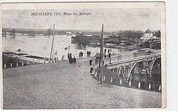
The Dnieper River in Dorogobuzh, Russian Empire, before 1917
-
The Dnieper River in Kremenchuk, Ukraine
-
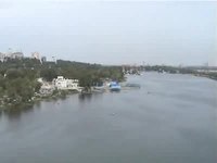
The Dnieper river in Ukraine from a helicopter, 2004
Cities
Major cities, over 100,000 in population, are in bold script. Cities and towns located on the Dnieper are listed in order from the river’s source (in Russia) to its mouth (in Ukraine):
|
|
Arheimar, a capital of the Goths, was located on the Dnieper, according to the Hervarar saga.
In the arts
Literature
The River Dnieper has been a subject of chapter X of a story by Nikolai Gogol A Terrible Vengeance (1831, published in 1832 as a part of the Evenings on a Farm Near Dikanka short stories collection). It is considered as a classical example of description of the nature in Russian literature. The river was also described in the works of Taras Shevchenko.
In the adventure novel The Long Ships (also translated Red Orm), set during the Viking Age, a Scanian chieftain travels to the Dnieper Rapids to retrieve a treasure hidden there by his brother, encountering many difficulties. The novel was very popular in Sweden and is one of few to depict a Viking voyage to eastern Europe.
Visual arts
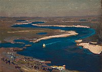
The River Dnieper has been a subject for artists, great and minor, over the centuries. Major artists with works based on the Dnieper are Arkhip Kuindzhi and Ivan Aivazovsky.
Films
The River Dnieper makes an appearance in the 1964 Hungarian drama film The Sons of the Stone-Hearted Man (based on the novel of the same name by Mór Jókai), where it appears when two characters are leaving Saint Petersburg but get attacked by wolves.
In 1983, the concert program “Song of the Dnieper” from the “Victory Salute” series was released, dedicated to the 40th anniversary of the liberation of the city of Kiev from the German fascist invaders. The program includes songs by Soviet composers, Ukrainian folk songs, and dances performed by the Song and Dance Ensemble of the Kiev Military District led by A. Pustovalov, P. Virsky Ukrainian National Folk Dance Ensemble, Kyiv Bandurist Capella, the Military Band of the Headquarters of the Kiev Military District led by A. Kuzmenko, singers Anatoliy Mokrenko, Lyudmila Zykina, Anatoliy Solovianenko, Dmytro Hnatyuk, Mykola Hnatyuk. Filming on the battlefield, streets and squares of Kiev. Scriptwriter – Victor Meerovsky. Directed by Victor Cherkasov. Operator – Alexander Platonov.
Music
In 1941, Mark Fradkin wrote “Song of the Dnieper” to the words of Yevgeniy Dolmatovsky.
Image gallery
- The Dnieper in painting
-

Catherine II leaving Kaniów in 1787 by Johann Gottlieb Plersch
-

Dnieper by Arkhip Kuindzhi, 1881
-

Moonlit Night on the Dnieper by Arkhip Kuindzhi, 1882
-

Ice in the Dnieper by Ivan Aivazovsky, 1872
-
Sapphire Dnieper by Jan Stanisławski, 1904
Popular culture
- The river is one of the symbols of the Ukrainian nation and is mentioned in the national anthem of Ukraine.
- There are several names that connect the name of the river with Ukraine: Overdnieper Ukraine, Right-bank Ukraine, Left-bank Ukraine, and others. Some of the cities on its banks — Dnipro, Dniprorudne, Kamianka-Dniprovska — are named after the river.
- The Zaporozhian Cossacks lived on the lower Dnieper and their name refers to their location “beyond the rapids”.
- The folk metal band Turisas have a song called “The Dnieper Rapids” on their 2007 album The Varangian Way.