
Purba Bardhaman district is in West Bengal. Its headquarters is in Bardhaman. It was formed on 7 April 2017 after the division of the previous Bardhaman district. Great revolutionary Rash Behari Bose was born in village Subaldaha in the district of Purba Bardhaman.
Etymology
Some historians link the name of the district to the 24th and last Jain tirthankara, Mahavira Vardhamana, who came to preach in the area. Alternatively, Bardhamana means a prosperous and growing area. It was a forward frontier zone in the progress of Aryanisation by the people in the Upper Gangetic valley. Purba means east.
History
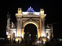
Curzon Gate in Bardhaman
The district is recorded in the early 20th century British chronicles as ‘the richest tract in Bengal and the area of its oldest and most settled cultivation’. Archaeological excavations at Pandu Rajar Dhibi have indicated settlements in the Ajay valley in the Mesolithic age, around 5,000 BC. In early historical times Bardhamanbhukti, a part of the Rarh region, was ruled successively by the Magadhas, Mauryas, Kushanas and Guptas. In the 7th century AD, when Shashanka was king, the area was part of the Gauda Kingdom. It was subsequently ruled by the Palas and Senas.
Bakhtiyar Khilji captured it in 1199 AD. The early Muslim rulers ruled over major parts of Bengal from Gauda or Lakhnauti. In Ain-i-Akbari, Bardhaman is mentioned as a mahal or pargana of Sarcar Sharifabad. Some western parts of Bardhaman formed Gopbhum, ruled for many centuries by the Sadgop kings. There are remains of a fort at Amrargar.
In 1689, Raja Krishnaram Roy, of the Bardhaman Raj family, obtained from Aurangzeb a farman (royal decree) which made him the zamindar (landlord) of Bardhaman, and since then the Raj family’s history became identical with that of the district. After the death of Aurangzeb, the Mughal Empire became weak and Murshid Quli Khan became the Nawab of Bengal, owning only nominal allegiance to the Mughal emperor. At that time Bardhaman was referred to as a chakla, a change from the earlier pargana. Subsequently, during the reign of Alivardi Khan, the Bargis attacked and plundered Bardhaman.
After the victory of the British in the Battle of Plassey in 1757, Bardhaman, Medinipur and Chittagong were ceded to the East India Company. In 1857, the British Crown took over the administration of the country from the East India Company.
In 1765, when East India Company acquired the diwani of Bardhaman, it was composed of Bardhaman, Bankura, Hooghly and a third of Birbhum. Hooghly was separated in 1820, Bankura and Birbhum in 1837.
In 1765, Tilakchand Ray, as the zamindar of Bardhaman, controlled 75 parganas and also looked after the law and order. At the time of the Permanent Settlement of Lord Cornwallis in 1793, the chaklas were reduced in size, in order to make them more manageable, and districts were created. Six subdivisions were created in Bardhaman district – Bud Bud in 1846, Katwa, Raniganj, Jahanabad (later named Arambagh), Bardhaman Sadar in 1847 and Kalna in 1850. The parganas were converted to thanas (police stations). At that time Bardhaman district had 22 thanas. Later, Jahanabad was transferred out of Bardhaman. Some minor changes continued.
The Permanent Settlement ultimately led to the dismemberment of the Bardhaman estate. As the rajas often failed to pay the rent demands, some parts of the estate were auctioned off. However, there were bright spots. Mahatabchand was appointed additional member of the Viceroy’s Executive Council and in 1877 was allowed to use the title of His Highness before his name. Bijoy Chand Mahatab was conferred the title of Maharajadhiraj by Lord Minto in 1908. Uday Chand Mahtab took over in 1941 and served till abolition of the zamindary system in 1954, after independence of the country.
Bardhaman district was bifurcated into two districts, Purba Bardhaman and Paschim Bardhman, on 7 April 2017.
Geography
Overview
Purba Bardhaman district is a flat alluvial plain area that can be divided into four prominent topographical regions. On the north, the Kanksa Ketugram Plain lies along the Ajay, which joins the Bhagirathi. The Bardhaman Plain occupies the central area of the district, with the Damodar on the south and the south-east. On the southern part is the Khandaghosh Plain. The Bhagirathi flows along the eastern boundary of the district, and the Bhagirathi Basin occupies the eastern part of the district. The undulating laterite topography of Paschim Bardhaman district extends up to Ausgram area of this district.

Roypara Gopal Jeu Temple at Majigram

A langcha shop in Saktigarh
Climate
Purba Bardhaman district has a tropical climate – hot and humid. While the hottest month is May, the coldest is January. The monsoon season is from June to September, with an annual average rainfall of 1,400 mm, 75% of it falling in the monsoon months. Localised thunderstorms, called kalbaisakhi in Bengali, are a special feature from March until the monsoon sets in.
Administrative divisions
Purba Bardhaman district is divided into the following administrative subdivisions:
| Subdivision | Headquarters | Area km2 |
Population (2011) |
Rural Population % (2011) |
Urban Population % (2011) |
|---|---|---|---|---|---|
| Bardhaman Sadar North | Bardhaman | 1,958.43 | 1,586,623 | 73.58 | 26.42 |
| Bardhaman Sadar South | Bardhaman | 1,410.03 | 1,198,155 | 95.54 | 4.46 |
| Katwa | Katwa | 1,070.48 | 963,022 | 88.44 | 11.56 |
| Kalna | Kalna | 993.75 | 1,097,732 | 87.00 | 13.00 |
| Purba Bardhaman district | Bardhaman | 5,432.69 | 4,835,532 | 84.98 | 15.02 |
The district comprises four subdivisions:
- Kalna subdivision consists of one municipality at Kalna and five CD blocks: Kalna I, Kalna II, Manteswar, Purbasthali I and Purbasthali II.
- Katwa subdivision consists of two municipalities at Katwa and Dainhat and five CD blocks: Katwa I, Katwa II, Ketugram I, Ketugram II and Mongakote.
- Bardhaman Sadar North subdivision consists of two municipalities at Bardhaman and Guskara and seven CD blocks: Ausgram I, Ausgram II, Bhatar, Burdwan I, Burdwan II, Galsi I and Galsi II.

Krishak Setu across the Damodar near Bardhaman
- Bardhaman Sadar South subdivision consists of one municipality at Memari and six CD blocks: Khandaghosh, Jamalpur, Memari I, Memari II, Raina I and Raina II.
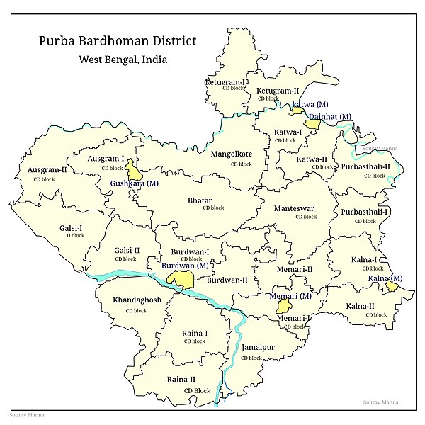
Map of purba bardhaman district
Demographics
As per the 2011 Census of India data, recast after bifurcation of Bardhaman district in 2017, Purba Bardhaman district had a total population of 4,835,532. There were 2,469,310 (51%) males and 2,366,222 (49%) females. Population below 6 years was 509,855.
As per the 2011 census data, recast after bifurcation of Bardhaman district in 2017, the total number of literates in Purba Bardhaman district was 3,232,452 (74.73% of the population over 6 years) out of which males numbered 1,781,090 (80.60% of the male population over 6 years) and females numbered 1,453,362 (68.66% of the female population over 6 years).