
|
Daund taluka
दौंड तालुका
|
|
|---|---|
|
Taluka
|
|
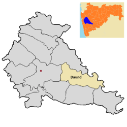
Location of Daund in Pune district in Maharashtra
|
|
| Coordinates: 18.4631°N 74.5789°ECoordinates: 18.4631°N 74.5789°E | |
| Country | |
| State | Maharashtra |
| District | Pune district |
| Headquarters | Daund |
| Government | |
| • Lok Sabha constituency | supriya sule |
| • Assembly constituency | Rahul shubhash kul |
| Area | |
| • Taluka | 1,290 km2(500 sq mi) |
| Population
(2011)
|
|
| • Taluka | 382,535 |
| • Density | 300/km2 (770/sq mi) |
| • Urban | 56,436 |

Daund taluka is a taluka or subdivision of Pune district of the state of Maharashtra in India. The town of Daund is the only major urban area in this predominantly rural area. Daund railway station is a major railway junction. All southern railways are connected to this route, and also divided the Nagar railway to north Indian railway, like Delhi, Solapur division, Daund junction and then joined to the Pune district junction. To reach the Siddhi Vinayak Siddhatek Ganpati temple, one has to travel 14 km to Daund by road.
In the winter season, when the temperature drops to 19 to 20℃, Daund has the most agricultural production of sugarcane. The riverbank farmers mostly plant sugarcane as their seasonal crop. The back water of the Ujani Dam riverbed region has Acacia tree forest. Many thorned-trees are found in this region. Three sugar factories are available in Daund 1)Daund sugar limited, Alegaon 2)Bhima Patas, Patas 3)Anuraj sugar limited, Yavat.