
Hassan
is one of the 31 districts of Karnataka, India. The district headquarter is Hassan.
Hassan District contains the cities of Hassan, Arsikere, Channarayapatna, Belur, Holenarasipura, Sakleshpur, Alur and Arkalgud.
Governance
Current Member of Parliament from Hassan is Prajwal Revanna who is also one of the youngest Lok Sabha members and is grandson of former Prime Minister of India H. D. Deve Gowda.
History
Hassan district was the seat of the Hoysala Empire which at its peak ruled large parts of south India from Belur as its early capital and Halebidu as its later capital during the period 1000 – 1334 CE.
The district is named Hassan after the Goddess “Haasanamba”, the goddess and presiding deity of the town. The history of Hassan district is essentially the history of two of the well known dynasties that have ruled Karnataka, the Western Ganga Dynasty of Talkad (350 – 999 CE) and the Hoysala Empire (1000 – 1334 CE). In the 15th and 16th centuries, the Vijayanagar kings patronised Chennakesava of Belur as their family deity. It was also ruled by Adilshahis of Bijapur and Mughal Empire after decline of the Vijayanagar. In the 17th and 18th centuries, Hassan became a land of contention between the Keladi Nayakas of Shimoga and the Mysore Kingdom. It finally merged as an independent Mysore kingdom.
Modern
During the 14th century, invasions by the Sultanate of Delhi weakened the Hoysala state, and the district became part of the Vijayanagara Empire. In the 15th and 16th centuries, the Vijayanagar kings patronised Chennakesava of Belur as their family deity. It was also ruled by Adilshahis of Bijapur and Mughal Empire after decline of the Vijayanagar. In the 17th and 18th centuries, Hassan became a land of contention between the Keladi Nayakas of Shimoga and the Mysore Kingdom. In 1648 the Mysore rulers built Channarayapatna fort by treaty with the sultans of Bijapur. A peace treaty was concluded between the Mysore and Keladi rulers in 1694. The district remained part of the Mysore Kingdom at the conclusion of the Fourth Anglo-Mysore War in 1799.
Hassan District and its current boundaries date to the 1860s, when the Mysore Kingdom was organized into 8 districts, and the districts further divided into taluks. The district had a population of 518,987 in the 1871 census. A famine from 1876 to 1878 reduced the population to 428,344 by 1881. The population was 511,975 in 1891, and 568,919 in 1901. The 1901 census recorded 541,531 Hindus, 16,668 Muslims, 5035 Animists, 3795 Christians, 1874 Jains, and 16 others. The district had 14 towns, and 2546 villages.
Reserve forests were established in the 19th century, and covered an area of 185 square miles in the district. The forests, with their area in square miles, were: Kempuhole Ghat (16), Kaganeri Ghati (2), Kabbinale Ghat (23), Bisale Ghat (23), Vijayapur (5), Hirikalgudda (92), Doddabetta (3), Burdalbore (3), Hagare (3), Byaba (2), Sige-gudda (8), Baisur (1), Mallappan-betta (1), and Vantigudda (1). The state established five sandalwood forests, totaling three square miles: Kemmanbore (232 acres), Gubbi (428 acres), Gadagere (554 acres), Gubbi (1000 acres), and Nakalgud (185 acres).
After India’s independence in 1947, Mysore Kingdom became Mysore State, which was renamed Karnataka state in 1973.
List of Temples
- Chennakesava Temple, Belur
- Hoysaleswara Temple, Halebidu
- Gommateshwara Statue, Shravanabelagola
- Hasanamba Temple, Hassan
Geography

Shettihalli Rosary Church also known as the Floating Church that submerged in water as a result of construction of the Hemavati Dam and Reservoir in 1960
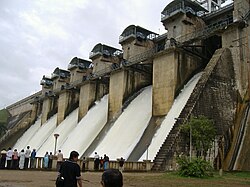
Hemavati Dam and Reservoir in Gorur
Lying between 12° 13´ and 13° 33´ North latitudes and 75° 33´ and 76°38´ East longitude, Hassan district has a total area of 6826.15 km². The geography is mixed with the malnad or mountainous region to the west and south west called Bisle Ghat and the maidan or plains regions in the north, south and east. There are some areas of degraded forest ranges in central portion of the district.
The district is surrounded by Chikmagalur District to the north west, Chitradurga District to the north, Tumkur District to the east, Mandya District to the south east, Mysore to the south, Kodagu District to the south west and Dakshina Kannada district to the west.
Hassan and Belur stand around 3,215 feet (980 m) and 3,210 feet (980 m) above sea level, respectively.
Most of the district lies in the watershed of the Hemavathi River, a tributary of the Kaveri River. The general level of Hassan district slopes with the course of the Hemavati, from the peaks of the Western Ghats downwards to the southeast. The chief tributary of the Hemavathi is the Yagachi River, which flows southward from Belur taluk to join the Hemavathi near Gorur. In 1981 the Hemavathi Dam was completed near Gorur, downstream from the confluence with the Yagachi, creating a reservoir of 8000 hectares. The Hemavathi passes through Holenarsipur taluk in a southerly direction and joins with the Kaveri near Hampapura in Mysore district, close to the border of Hassan district. The Kaveri flows through the southernmost part of the District.
Western portions of the district are drained by the headwaters of the Netravati River, which flows northwestward to empty into the Arabian Sea. Portions of Asikere taluk in the northeast are drained by the Hogari River, a tributary of the Tungabhadra River. The basins of the Kaveri and Tungabhadra are separated by a range of low granitic hills extending through Belur, Hassan, and Arsikere taluks.
The Bisle Ghat, or Bisale Ghat, is a portion of the Western Ghats range in the western part of the district. Main peaks include Jenkalbetta (4,558 feet (1,389 m)), the highest peak in the district, Murkangudda (4,265 feet (1,300 m)), and Devarbetta (4,206 feet (1,282 m)). Pushpagiri (1,712 meters), lies immediately southwest in Kodagu and Dakshina Kannada districts. Bisle, Kagneri, Kanchankumari reserve forests cover portions the Bisle Ghat, and adjoin Pushpagiri Wildlife Sanctuary in Kodagu.
Administrative divisions
Hassan District is administratively divided into eight talukas (Panchayat blocks): Alur, Arkalgud, Arsikere, Belur, Channarayapatna, Hassan, Holenarasipura (H.N. Pura) and Sakleshpur, and 258 panchayat villages.
Demographics

Profile of the Kedareshwara temple at Halebidu
According to the 2011 census Hassan district has a population of 1,776,421, roughly equal to the nation of The Gambia or the US state of Nebraska. This gives it a ranking of 270th in India (out of a total of 640). The district has a population density of 261 inhabitants per square kilometre (680/sq mi) . Its population growth rate over the decade 2001-2011 was 3.17%. Hassan has a sex ratio of 1005 females for every 1000 males, and a literacy rate of 75.89%. Scheduled Castes and Scheduled Tribes make up 19.42% and 1.82% of the population respectively.
Languages of Hassan district (2011)
At the time of the 2011 census, 87.04% of the population spoke Kannada, 6.16% Urdu, 1.96% Telugu and 1.22% Tulu as their first language.
| Year | Pop. | ±% p.a. |
|---|---|---|
| 1901 | 568,919 | — |
| 1911 | 578,097 | +0.16% |
| 1921 | 581,750 | +0.06% |
| 1931 | 596,937 | +0.26% |
| 1941 | 627,718 | +0.50% |
| 1951 | 715,135 | +1.31% |
| 1961 | 895,847 | +2.28% |
| 1971 | 1,102,370 | +2.10% |
| 1981 | 1,357,014 | +2.10% |
| 1991 | 1,569,684 | +1.47% |
| 2001 | 1,721,669 | +0.93% |
| 2011 | 1,776,421 | +0.31% |
| source: | ||
Transport
Air
There is no operational airport in the city. The nearest airport is Mysore airport and the nearest international airport is Kempegowda International Airport. Hassan Airport is a proposed airport 10 kilometer east of the city near Boovanahalli village but the project failed to take off. Government of India has granted the approval for setting up of 15 Greenfield airports in the country on May 12, 2015. Among 15 Airports Hassan Also approved for Greenfield Airport.
Road
The Karnataka State Road Transport Corporation operates connecting Hassan with other parts of Karnataka as well as other states. Hassan is connected by road via national highway No. 75 to the rest of the country.
Rail
Hassan comes under the South Western Railway zone of the Indian Railways. Hassan Junction railway station connects it to the rest of the country through the Indian Railways
Education
- Government Engineering College, Hassan
- Kendriya Vidyalaya
- Malnad College of Engineering
- St. Joseph’s College, Hassan
- Rajeev Institute of Technology
Gallery
-

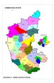
Positioning of Hassan district in Karnataka
-
Positioning of Hassan district in Karnataka (Including Taluks)
-
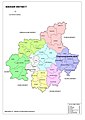
Hobli Map of Hassan district
-
Hobli Map with Regions shading
-

District Tourism Map
-
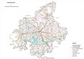
Road Network of Hassan district
-
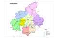
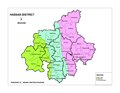
Taluks of Hassan district
People from the Hassan district
- H.C Srikantaiah, Former Minister and Member of Parliament
- Gorur Ramaswamy Iyengar, Kannada literature
- Javagal Srinath, cricketer
- H. D. Deve Gowda, 11th Prime Minister of India
- S.L. Bhyrappa, writer
- Dheerendra Gopal, film actor
- Doddanna, film actor
- David Johnson, Ranji player
- Dhananjay, film actor
- G.R. Gopinath, founder of Air Deccan
- H. D. Revanna, politician
- H.D. Kumaraswamy, Former Chief Minister, Karnataka
- Narayana Gowda, Karnataka Rakshana Vedike state president
- Chandan Shetty, Kannada rapper
- Veera Ballala II, Hoysala king
- Veera Ballala III, Hoysala king
- Vishnuvardhana, Hoysala king
- Yash, film actor
- Prashanth Neel, Kannada film director
- Milana Nagaraj, Kannada film actress
- Vasishta N. Simha, film actor
- Prathap Simha, politician
- C. N. Manjunath, Cardiologist and the Director of the Sri Jayadeva Institute of Cardiovascular Sciences and Research