
The state of Andhra Pradesh is divided into 13 districts spread across two unofficial regions —Coastal Andhra and Rayalaseema. Coastal Andhra consists of East Godavari, West Godavari, Krishna, Guntur, Prakasam, Sri Potti Sri Ramulu Nellore, Srikakulam, Vizianagaram, and Visakhapatnam districts. Rayalaseema comprises Kurnool, Chittoor, YSR Kadapa and Anantapur districts. Anantapur is the largest district in area while Srikakulam is the smallest. East Godavari is the most populous whereas Vizianagaram is the least populous. The districts are further divided into two or more revenue divisions and Mandals for administrative purposes.
History
At the time of Independence the present day Andhra Pradesh was a part of Madras State. Coastal Andhra and Rayalaseema were separated from Madras State to form Andhra State in 1953
As a result of the 1956 States Reorganisation Act, the state’s boundaries were re-organized following linguistic lines. On 1 November 1956, Andhra State and the Telangana region of Hyderabad state were merged to form the united Andhra State and was renamed as Andhra Pradesh. The present day Andhra Pradesh while formation had 11 districts. They are as follows:
- Anantapur, Chittoor, East Godavari, Guntur, YSR Kadapa, Krishna, Kurnool, Nellore, Prakasam, Srikakulam, Visakhapatnam and West Godavari
- Prakasam district was created out of parts of Guntur district, Nellore district and Kurnool district in 1970.
- Vizianagaram district was created out of parts of Visakhapatnam district and Srikakulam district in 1979.
Districts
| S.No | Code | District | Headquarters | Largest city |
Revenue divisions | Mandals | Population | Area (in sq.km) |
Density (per sq.km) |
Sex ratio | Map |
|---|---|---|---|---|---|---|---|---|---|---|---|
| 1 | AN | Anantapur | Anantapur | Anantapur | 5 | 63 | 4,083,315 | 19,130 | 213 | 977/1000 |  |
| 2 | CH | Chittoor | Chittoor | Tirupati | 3 | 66 | 4,170,468 | 15,152 | 275 | 985/1000 |  |
| 3 | EG | East Godavari | Kakinada | Rajamahendravaram | 7 | 64 | 5,151,549 | 10,807 | 477 | 1005/1000 |  |
| 4 | GU | Guntur | Guntur | Guntur | 4 | 57 | 4,889,230 | 11,391 | 429 | 1003/1000 |  |
| 5 | CU | Kadapa | Kadapa | Kadapa | 3 | 50 | 2,884,524 | 15,359 | 188 | 985/1000 |  |
| 6 | KR | Krishna | Machilipatnam | Vijayawada | 4 | 50 | 4,529,009 | 8,727 | 519 | 992/1000 | 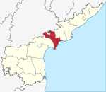 |
| 7 | KU | Kurnool | Kurnool | Kurnool | 3 | 54 | 4,046,601 | 17,658 | 229 | 988/1000 |  |
| 8 | NE | Nellore | Nellore | Nellore | 5 | 56 | 2,966,082 | 13,076 | 227 | 986/1000 | 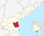 |
| 9 | PR | Prakasam | Ongole | Ongole | 3 | 56 | 3,392,764 | 17,626 | 193 | 981/1000 | 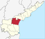 |
| 10 | SR | Srikakulam | Srikakulam | Srikakulam | 3 | 37 | 2,699,471 | 5,837 | 462 | 1015/1000 | 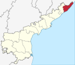 |
| 11 | VS | Visakhapatnam | Visakhapatnam | Visakhapatnam | 4 | 46 | 4,288,113 | 11,161 | 340 | 1006/1000 |  |
| 12 | VZ | Vizianagaram | Vizianagaram | Vizianagaram | 2 | 34 | 2,342,868 | 6,539 | 384 | 1016/1000 |  |
| 13 | WG | West Godavari | Eluru | Eluru | 4 | 46 | 3,934,782 | 7,742 | 490 | 1004/1000 |  |