
Shimoga district, officially known as Shivamogga district, is a district in the Karnataka state of India. A major part of Shimoga district lies in the Malnad region or the Sahyadri. Shimoga city is its administrative centre. Jog Falls view point is a major tourist attraction. As of 2011 Shimoga district has a population of 17,52,753. There are seven taluks: Soraba, Sagara, Hosanagar, Shimoga, Shikaripura, Thirthahalli, and Bhadravathi. Channagiri and Honnali were part of Shimoga district until 1997 when they became part of the newly formed Davanagere district.
Origin of name
Shivamogga was previously known as Mandli. There are legends about how the name Shivamogga has evolved. According to one, the name Shivamogga is related to the Hindu God Shiva. Shiva-Mukha (Face of Shiva), Shivana-Moogu (Nose of Shiva) or Shivana-Mogge (Flowers to be offered to Shiva) can be the origins of the name “Shivamogga”. Another legend indicates that the name Shimoga is derived from the word Sihi-Moge which means sweet pot. According to this legend, Shivamogga once had the ashram of the sage Durvasa. He used to boil sweet herbs in an earthen pot. Some cowherds, found this pot and after tasting the sweet beverage named this place Sihi-Moge.
History

Outer wall carving, Aghoreshwara temple, Ikkeri, Sagar taluk Shimoga District.
During Treta Yuga, Lord Rama killed Maricha, who was in the disguise of a deer at Mrugavadhe near Thirthahalli. The Shimoga region formed a part of the Mauryan empire during the 3rd century. The district came into the control of Satavahanas. The Satakarni inscription has been found in the Shikaripur taluk. After the fall of the Shatavahana empire around 200 CE, the area came under the control of the Kadambas of Banavasi around 345 CE. The Kadambas were the earliest kingdom to give administrative status to the Kannada language. Later the Kadambas became feudatories of the Badami Chalukyas around 540 CE.
In the 8th century Rashtrakutas ruled this district. The Kalyani Chalukyas overthrew the Rashtrakutas, and the district came into their rule. Balligavi was a prominent city during their rule. In the 12th century, with the weakening of the Kalyani Chalukyas, the Hoysalas annexed this area. After the fall of the Hoysalas, the entire region came under the Vijayanagar Empire. When the Vijayanagar empire was defeated in 1565 CE in the battle of Tallikota, the Keladi Nayakas who were originally feudatory of the Vijayanagar empire took control, declared sovereignty, and ruled as an independent kingdom for about two centuries. In 1763 Haider Ali captured the capital of Keladi Nayakas and as a result the district came into the rule of the Kingdom of Mysore and remained a part of it until India acquired independence from the British.
Geography
Shimoga district is a part of the Malnad region of Karnataka and is also known as the ‘Gateway to Malnad’ or ‘Malenaada Hebbagilu’ in Kannada. The district is landlocked and bounded by Haveri, Davanagere, Chikmagalur, Udupi and Uttara Kannada districts. The district ranks 9th in terms of the total area among the districts of Karnataka. It is spread over an area of 8465 km2.
Shimoga lies between the latitudes 13°27′ and 14°39′ N and between the longitudes 74°38′ and 76°04′ E at a mean altitude of 640 metres above sea level. The peak Kodachadri hill at an altitude of 1343 metres above sea level is the highest point in this district. Rivers Kali, Gangavati, Sharavati and Tadadi originate in this district. The two major rivers that flow through this district are Tunga and Bhadra which meet at Koodli near Shimoga city to gain the name of Tungabhadra, which later joins River Krishna.
Climate
As the district lies in the tropical region, rainy season occurs from June to October. In the years 1901–1970, Shimoga received an average annual rainfall of 1813.9 mm with an average of 86 days in the year being rainy days. The average annual temperature of Shimoga district is around 26 °C. The average temperature has increased substantially over the years. In some regions of the district, the day temperature can reach 40 °C during summer. This has led to water crisis and other problems.
Geology
- The major soil forms found in the Shimoga district are red gravelly clay soil; red clay soil; lateritic gravelly clay soil; lateritic clay soil; medium deep black soil; non-saline and saline alluvio-colluvial soil; brown forest soil.
- The major minerals found in the district are limestone; white quartz; kaolin; kyanite; manganese.
The plain land of the district is suitable for agriculture.
Economy
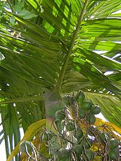
Cornerstone of the Shimoga district’s agrarian economy: the arecanut.
Foundry, agriculture and animal husbandry are the major contributors to the economy of Shimoga district. The crops cultivated in this district are paddy, arecanut, cotton, maize, oil seeds, cashewnut, pepper, chili, ginger, Ragi. Karnataka is the largest producer of arecanut in India, the majority of which is cultivated in the Shimoga district. The farmers have cultivated crops like Vanilla and Jatropha that has yielded high monetary benefits. Spices like, clove, pepper, cinnamon, cardamom are grown along with areaca plants. This multi cropping can help in maximum utilisation of land space and improve soil fertility. As spices have high commercial value it provides additional income to farmers.
Industries
Iron, agriculture, Textiles and engineering are the major industries in Shimoga district. Foundry activity has a long history there and Pearlite Liners (P) Led., one of the oldest industries of Karnataka (earlier known as Bharath Foundry), is the largest private-sector employer in the district. As of 2000, there were about 9800 industrial units in Shimoga District (small, medium and large), with more than 41,000 employees.
Major investments are made in food; beverages, engineering, and mechanical goods. Other rural industries in this district are carpentry, blacksmith, leather, pottery, beekeeping, stone cutting, handlooms, agarbathi, and sandalwood carving.
Karnataka government has created industrial regions to encourage industrialisation of the district: KIADB Nidige Industrial area in Bhadravathi taluk; Machinahaali Industrial Area. Mandli-Kallur Industrial area in Shimoga taluk; Shimoga Industrial estate in Shimoga; Kallahalli Industrial estate in Shimoga. KIADB Devakathikoppa Industrial Area. KSSIDC Siddlipura Industrial Area. Major industries in Shimoga district are VISL and MPM.
Administrative divisions
Shimoga district is divided into seven taluks: Soraba, Bhadravathi, Thirthahalli, Sagara, Shikaripura, Shimoga and Hosanagara.
The district administration is headed by the deputy commissioner who has the additional role of a district magistrate. Assistant commissioners, tahsildars, shirastedars, revenue inspectors and village accountants help the deputy commissioner in the administration of the district. The headquarters is Shimoga city.
The Shimoga Lok Sabha constituency comprises the entire Shimoga district and also covers parts of Nalluru and Ubrani hoblis of Channagiri taluk of Davanagere district. As of 2005 it had 1,286,181 voters: Scheduled Castes and Scheduled Tribes account for 2.2 lakhs; Lingayats account for two lakhs; Deevaru (Idiga)account for 1.8 lakh; (Madivala) account for 1.2 lakh;Muslims account for 1.6 lakh; Brahmins and Vokkaligas account for 1.25 lakh each. Seven members are elected to the Legislative assembly of the state of Karnataka. The assembly constituencies in Shimoga district are:
- Soraba
- Sagara
- Shimoga
- Shimoga Rural
- Shikaripura
- Bhadravathi
- Thirthahalli
Demographics
| Year | Pop. | ±% p.a. |
|---|---|---|
| 1901 | 383,007 | — |
| 1911 | 367,303 | −0.42% |
| 1921 | 354,101 | −0.37% |
| 1931 | 364,903 | +0.30% |
| 1941 | 381,059 | +0.43% |
| 1951 | 475,999 | +2.25% |
| 1961 | 763,076 | +4.83% |
| 1971 | 988,744 | +2.62% |
| 1981 | 1,261,582 | +2.47% |
| 1991 | 1,452,259 | +1.42% |
| 2001 | 1,642,545 | +1.24% |
| 2011 | 1,752,753 | +0.65% |
| source: | ||
According to the 2011 census Shimoga district has a population of 1,752,753, which is roughly equal to population of the nation Gambia and the state of Nebraska of the United States. The district ranks 275th in India out of a total of 640 districts. The district has a population density of 207 inhabitants per square kilometre (540/sq mi). Its population growth rate over the decade 2001–2011 was 6.88%. Shimoga has a sex ratio of 995 females per 1000 males and a literacy rate of 80.5%. Scheduled Castes and Scheduled Tribes make up 17.58% and 3.73% of the population respectively.
Shimoga taluk has the highest population with Hosanagara taluk having the lowest. The district has a sex ratio of 977 females to 1000 males. Shimoga Taluk having 991 females to 1000 males has the lowest sex-ratio.
| Taluk name | Number of households | Population | Males | Females |
|---|---|---|---|---|
| Soraba | 37,363 | 185,572 | 94,267 | 91,305 |
| Shimoga | 93,426 | 445,192 | 226,928 | 218,264 |
| Bhadravati | 71,771 | 338,989 | 171,917 | 167,072 |