
Somerset is a county in South West England which borders Gloucestershire and Bristol to the north, Wiltshire to the east, Dorset to the south-east and Devon to the south-west. It is bounded to the north and west by the Severn Estuary and the Bristol Channel, its coastline facing southeastern Wales. Its traditional border with Gloucestershire is the River Avon. Somerset’s county town is Taunton.
Somerset is a rural county of rolling hills, the Blackdown Hills, Mendip Hills, Quantock Hills and Exmoor National Park, and large flat expanses of land including the Somerset Levels. There is evidence of human occupation from Paleolithic times, and of subsequent settlement by the Celts, Romans and Anglo-Saxons. The county played a significant part in Alfred the Great’s rise to power, and later the English Civil War and the Monmouth Rebellion. The city of Bath is famous for its Georgian architecture and is a UNESCO World Heritage Site.
Toponymy
Somerset’s name derives from Old English Sumorsǣte, short for Sumortūnsǣte, meaning “the people living at or dependent on Sumortūn (Somerton)”. The first known use of Somersæte is in the law code of King Ine who was the Saxon King of Wessex from 688–726 ce, making Somerset along with Hampshire, Wiltshire and Dorset one of the oldest extant units of local government in the world. An alternative suggestion is the name derives from Seo-mere-saetan meaning “settlers by the sea lakes”.
The Old English name is used in the motto of the county, Sumorsǣte ealle, meaning “all the people of Somerset”. Adopted as the motto in 1911, the phrase is taken from the Anglo-Saxon Chronicle. Somerset was a part of the Anglo-Saxon kingdom of Wessex, and the phrase refers to the wholehearted support the people of Somerset gave to King Alfred in his struggle to save Wessex from Viking invaders.
Somerset settlement names are mostly Anglo-Saxon in origin (for example, Bath, Somerton, Wells and Keynsham), but numerous place names include British Celtic elements, such as the rivers Frome and Avon, and names of hills. For example, an Anglo-Saxon charter of 682 refers to Creechborough Hill as “the hill the British call Cructan and the Anglo-Saxons call Crychbeorh“. Some modern names are wholly Brittonic in origin, like Tarnock, Priddy, and Chard, while others have both Saxon and Brittonic elements, such as Pen Hill.
History
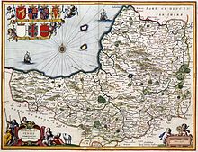
A map of the county in 1646, author unknown
Prehistory
The caves of the Mendip Hills were settled during the Palaeolithic period, and contain extensive archaeological sites such as those at Cheddar Gorge. Bones from Gough’s Cave have been dated to 12,000 bce, and a complete skeleton, known as Cheddar Man, dates from 7150 bce. Examples of cave art have been found in Aveline’s Hole. Some caves continued to be occupied until modern times, including Wookey Hole.
The Somerset Levels—specifically dry points at Glastonbury and Brent Knoll— also have a long history of settlement, and are known to have been settled by Mesolithic hunters. Travel in the area was facilitated by the construction of one of the world’s oldest known engineered roadways, the Sweet Track, which dates from 3807 bce or 3806 bce.
The exact age of the henge monument at Stanton Drew stone circles is unknown, but it is believed to be Neolithic. There are numerous Iron Age hill forts, some of which, like Cadbury Castle and Ham Hill, were later reoccupied in the Early Middle Ages.
Roman invasion
On the authority of the future emperor Vespasian, as part of the ongoing expansion of the Roman presence in Britain, the Second Legion Augusta invaded Somerset from the south-east in 47 ce. The county remained part of the Roman Empire until around 409 ce, when the Roman occupation of Britain came to an end. A variety of Roman remains have been found, including Pagans Hill Roman temple in Chew Stoke, Low Ham Roman Villa and the Roman Baths that gave their name to the city of Bath.
Saxon and Norman invasions

Palladian Pulteney Bridge at Bath
After the Romans left, Britain was invaded by Anglo-Saxon peoples. By 600 ce they had established control over much of what is now England, but Somerset was still in native British hands. The British held back Saxon advance into the south-west for some time longer, but by the early eighth century King Ine of Wessex had pushed the boundaries of the West Saxon kingdom far enough west to include Somerset. The Saxon royal palace in Cheddar was used several times in the 10th century to host the Witenagemot.
The nature of the relations between the Britons and the Saxons in Somerset is not entirely clear. Ine’s laws demonstrate that the Britons were considered to be a significant enough population in Wessex to merit provisions; however, the laws also suggest that Britons could not attain the same social standing as the Saxons, and that many were slaves. In light of such policies, many Britons might have chosen to emigrate to places such as Brittany while those who remained would have had incentives to adopt Anglo-Saxon culture.
After the Norman Conquest, the county was divided into 700 fiefs, and large areas were owned by the crown, with fortifications such as Dunster Castle used for control and defence.
The 17th–19th centuries
Somerset contains HM Prison Shepton Mallet, which was England’s oldest prison still in use prior to its closure in 2013, having opened in 1610. In the English Civil War Somerset was largely Parliamentarian, with key engagements being the Sieges of Taunton and the Battle of Langport.
In 1685 the Monmouth Rebellion was played out in Somerset and neighbouring Dorset. The rebels landed at Lyme Regis and travelled north, hoping to capture Bristol and Bath, but they were defeated in the Battle of Sedgemoor at Westonzoyland, the last pitched battle fought in England.
Arthur Wellesley took his title, Duke of Wellington from the town of Wellington; he is commemorated on a nearby hill by a large, spotlit obelisk, known as the Wellington Monument.
The Industrial Revolution in the Midlands and Northern England spelled the end for most of Somerset’s cottage industries. Farming continued to flourish, and the Bath and West of England Society for the Encouragement of Agriculture, Arts, Manufactures and Commerce was founded in 1777 to improve farming methods. Despite this, 20 years later John Billingsley conducted a survey of the county’s agriculture in 1795 and found that agricultural methods could still be improved. Coal mining was an important industry in north Somerset during the 18th and 19th centuries, and by 1800 it was prominent in Radstock.
The Somerset Coalfield reached its peak production by the 1920s. All the pits have now been closed, the last in 1973. Most of the surface buildings have been removed, and apart from a winding wheel outside Radstock Museum, little evidence of their former existence remains. Further west, the Brendon Hills were mined for iron ore in the late 19th century; this was taken by the West Somerset Mineral Railway to Watchet Harbour for shipment to the furnaces at Ebbw Vale.
20th century
Many Somerset soldiers died during the First World War, with the Somerset Light Infantry suffering nearly 5,000 casualties. War memorials were put up in most of the county’s towns and villages; only nine, described as the Thankful Villages, had none of their residents killed. During the Second World War the county was a base for troops preparing for the D-Day landings. Some of the hospitals which were built for the casualties of the war remain in use. The Taunton Stop Line was set up to repel a potential German invasion. The remains of its pill boxes can still be seen along the coast, and south through Ilminster and Chard.
A number of decoy towns were constructed in Somerset in World War II to protect Bristol and other towns. They were designed to mimic the nighttime geometry of “blacked out” streets, railway lines, and Bristol Temple Meads railway station, to encourage German bombers away from these targets. One, on the German radio navigation beam flight path to Bristol, was constructed on Beacon Batch. It was laid out by Shepperton Studios, based on aerial photographs of the city’s railway marshalling yards. The decoys were fitted with dim red lights, simulating activities such as the stoking of steam locomotives. Burning bales of straw soaked in creosote were used to simulate the effects of incendiary bombs dropped by the first wave of Pathfinder night bombers; meanwhile, incendiary bombs dropped on the correct location were quickly smothered, wherever possible. Drums of oil were also ignited to simulate the effect of a blazing city or town, with the aim of fooling subsequent waves of bombers into dropping their bombs on the wrong location. The Chew Magna decoy town was hit by half a dozen bombs on 2 December 1940, and over a thousand incendiaries on 3 January 1941. The following night the Uphill decoy town, protecting the airfield at Weston-super-Mare, was bombed; a herd of dairy cows was hit, killing some and severely injuring others.
Human geography
Boundaries

The Avon Gorge, the historic boundary between Gloucestershire and Somerset, and also Mercia and Wessex; Somerset is to the left
The boundaries of Somerset are very similar to how they were in medieval times. They have been largely unaltered. The River Avon formed much of the border with Gloucestershire, except that the hundred of Bath Forum, which straddles the Avon, formed part of Somerset. Bristol began as a town on the Gloucestershire side of the Avon, however as it grew it extended across the river into Somerset. In 1373 Edward III proclaimed “that the town of Bristol with its suburbs and precincts shall henceforth be separate from the counties of Gloucester and Somerset … and that it should be a county by itself”.
The present-day northern border of Somerset (adjoining the counties of Bristol and Gloucestershire) runs along the southern bank of the Avon from the Bristol Channel, then follows around the southern edge of the Bristol built-up area, before continuing upstream along the Avon, and then diverges from the river to include Bath and its historic hinterland to the north of the Avon, before meeting Wiltshire at the Three Shire Stones on the Fosse Way at Batheaston.
Cities and towns
Somerton took over from Ilchester as the county town in the late thirteenth century, but it declined in importance and the status of county town transferred to Taunton about 1366. The county has two cities, Bath and Wells, and 30 towns (including the county town of Taunton, which has no town council but instead is the chief settlement of the county’s only extant borough). The largest urban areas in terms of population are Bath, Weston-super-Mare, Taunton, Yeovil and Bridgwater.
Many settlements developed because of their strategic importance in relation to geographical features, such as river crossings or valleys in ranges of hills. Examples include Axbridge on the River Axe, Castle Cary on the River Cary, North Petherton on the River Parrett, and Ilminster, where there was a crossing point on the River Isle. Midsomer Norton lies on the River Somer; while the Wellow Brook and the Fosse Way Roman road run through Radstock. Chard is the most southerly town in Somerset and one of the highest, though at an altitude of 126 m (413 ft) Wiveliscombe is the highest town in the county.
Green belt
The county contains several-miles-wide sections of the Avon green belt area, which is primarily in place to prevent urban sprawl from the Bristol and Bath built up areas encroaching into the rural areas of North Somerset, Bath and North East Somerset, and Mendip districts in the county, as well as maintaining surrounding countryside. It stretches from the coastline between the towns of Portishead and Clevedon, extending eastwards past Nailsea, around the Bristol conurbation, and through to the city of Bath. The green belt border intersects with the Mendip Hills Area of Outstanding Natural Beauty (AONB) along its south boundary, and meets the Cotswolds AONB by its eastern extent along the Wiltshire county border, creating an extended area protected from inappropriate development.
Physical geography
Geology
Much of the landscape of Somerset falls into types determined by the underlying geology. These landscapes are the limestone karst and lias of the north, the clay vales and wetlands of the centre, the oolites of the east and south, and the Devonian sandstone of the west.

The River Brue in an artificial channel draining farmland near Glastonbury
To the north-east of the Somerset Levels, the Mendip Hills are moderately high limestone hills. The central and western Mendip Hills was designated an Area of Outstanding Natural Beauty in 1972 and covers 198 km2 (76 sq mi). The main habitat on these hills is calcareous grassland, with some arable agriculture. To the south-west of the Somerset Levels are the Quantock Hills which was England’s first Area of Outstanding Natural Beauty designated in 1956 which is covered in heathland, oak woodlands, ancient parklands with plantations of conifer and covers 99 square kilometres. The Somerset Coalfield is part of a larger coalfield which stretches into Gloucestershire. To the north of the Mendip hills is the Chew Valley and to the south, on the clay substrate, are broad valleys which support dairy farming and drain into the Somerset Levels.
Caves and rivers
There is an extensive network of caves, including Wookey Hole, underground rivers, and gorges, including the Cheddar Gorge and Ebbor Gorge. The county has many rivers, including the Axe, Brue, Cary, Parrett, Sheppey, Tone and Yeo. These both feed and drain the flat levels and moors of mid and west Somerset. In the north of the county the River Chew flows into the Bristol Avon. The Parrett is tidal almost to Langport, where there is evidence of two Roman wharfs. At the same site during the reign of King Charles I, river tolls were levied on boats to pay for the maintenance of the bridge.
Levels and moors

The town of Glastonbury looking west from the top of Glastonbury Tor. The fields in the distance are the Somerset Levels.
The Somerset Levels (or Somerset Levels and Moors as they are less commonly but more correctly known) are a sparsely populated wetland area of central Somerset, between the Quantock and Mendip hills. They consist of marine clay levels along the coast, and the inland (often peat based) moors. The Levels are divided into two by the Polden Hills. Land to the south is drained by the River Parrett while land to the north is drained by the River Axe and the River Brue. The total area of the Levels amounts to about 647.5 square kilometres (160,000 acres) and broadly corresponds to the administrative district of Sedgemoor but also includes the south west of Mendip district. Approximately 70% of the area is grassland and 30% is arable.
Stretching about 32 kilometres (20 mi) inland, this expanse of flat land barely rises above sea level. Before it was drained, much of the land was under a shallow brackish sea in winter and was marsh land in summer. Drainage began with the Romans, and was restarted at various times: by the Anglo-Saxons; in the Middle Ages by the Glastonbury Abbey, during 1400–1770; and during the Second World War, with the construction of the Huntspill River. Pumping and management of water levels still continues.
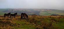
The Exmoor landscape with the native Exmoor Pony
The North Somerset Levels basin, north of the Mendips, covers a smaller geographical area than the Somerset Levels; and forms a coastal area around Avonmouth. It too was reclaimed by draining. It is mirrored, across the Severn Estuary, in Wales, by a similar low-lying area: the Caldicot and Wentloog Levels.
In the far west of the county, running into Devon, is Exmoor, a high Devonian sandstone moor, which was designated as a national park in 1954, under the 1949 National Parks and Access to the Countryside Act. The highest point in Somerset is Dunkery Beacon on Exmoor, with an altitude of 519 metres (1,703 feet).
Over 100 sites in Somerset have been designated as Sites of Special Scientific Interest.
Coastline

Brean Down from Steep Holm

The marina in Watchet
The 64 km (40 mi) coastline of the Bristol Channel and Severn Estuary forms part of the northern border of Somerset. The Bristol Channel has the second largest tidal range in the world. At Burnham-on-Sea, for example, the tidal range of a spring tide is more than 12 metres (39 feet). Proposals for the construction of a Severn Barrage aim to harness this energy. The island of Steep Holm in the Bristol Channel is within the ceremonial county and is now administered by North Somerset Council.
The main coastal towns are, from the west to the north-east, Minehead, Watchet, Burnham-on-Sea, Weston-super-Mare, Clevedon and Portishead. The coastal area between Minehead and the eastern extreme of the administrative county’s coastline at Brean Down is known as Bridgwater Bay, and is a National Nature Reserve. North of that, the coast forms Weston Bay and Sand Bay whose northern tip, Sand Point, marks the lower limit of the Severn Estuary. In the mid and north of the county the coastline is low as the level wetlands of the levels meet the sea. In the west, the coastline is high and dramatic where the plateau of Exmoor meets the sea, with high cliffs and waterfalls.
Climate
Along with the rest of South West England, Somerset has a temperate climate which is generally wetter and milder than the rest of the country. The annual mean temperature is approximately 10 °C (50.0 °F). Seasonal temperature variation is less extreme than most of the United Kingdom because of the adjacent sea temperatures. The summer months of July and August are the warmest with mean daily maxima of approximately 21 °C (69.8 °F). In winter mean minimum temperatures of 1 °C (33.8 °F) or 2 °C (35.6 °F) are common. In the summer the Azores high pressure affects the south-west of England, but convective cloud sometimes forms inland, reducing the number of hours of sunshine. Annual sunshine rates are slightly less than the regional average of 1,600 hours.
In December 1998 there were 20 days without sun recorded at Yeovilton. Most of the rainfall in the south-west is caused by Atlantic depressions or by convection. Most of the rainfall in autumn and winter is caused by the Atlantic depressions, which is when they are most active. In summer, a large proportion of the rainfall is caused by sun heating the ground leading to convection and to showers and thunderstorms. Average rainfall is around 700 mm (28 in). About 8–15 days of snowfall is typical. November to March have the highest mean wind speeds, and June to August the lightest winds. The predominant wind direction is from the south-west.
| hideClimate data for Yeovilton, England (1981–2010) data | |||||||||||||
|---|---|---|---|---|---|---|---|---|---|---|---|---|---|
| Month | Jan | Feb | Mar | Apr | May | Jun | Jul | Aug | Sep | Oct | Nov | Dec | Year |
| Average high °C (°F) | 8.1 (46.6) |
8.3 (46.9) |
10.6 (51.1) |
12.9 (55.2) |
16.5 (61.7) |
19.3 (66.7) |
21.7 (71.1) |
21.5 (70.7) |
18.6 (65.5) |
14.8 (58.6) |
11.1 (52.0) |
9.0 (48.2) |
14.4 (57.9) |
| Daily mean °C (°F) | 4.8 (40.6) |
4.8 (40.6) |
6.7 (44.1) |
8.3 (46.9) |
11.7 (53.1) |
14.5 (58.1) |
16.8 (62.2) |
16.6 (61.9) |
|||||