
Territorial disputes have occurred throughout history, over lands around the world. Bold indicates one claimant’s full control; italics indicates one or more claimants’ partial control.
Ongoing disputes between UN member/observer states
Africa
| Territory | Claimants | Notes |
|---|---|---|
| Abyei, Heglig, Jodha, Kafia Kingi and Kaka | Both Sudan and South Sudan have claimed the area after the civil war that led to South Sudan’s independence. Heglig was controlled by South Sudan in mid-April 2012 but retaken by the Sudan. Abyei was taken in May 2012. | |
| Banc du Geyser | Scattered Islands in the Indian Ocean, a district of the French Southern Territories. | |
| Bassas da India, Europa Island and Juan de Nova Island | De facto a part of the French overseas territory of the French Southern Territories. | |
| Ceuta, Melilla, other plazas de soberanía | Ceuta and Melilla are administered by Spain as autonomous cities.An incident on Perejil Island happened in 2002, after which both countries agreed to return to status quo. | |
| Chagos Archipelago | United Kingdom administers the archipelago as part of the British Indian Ocean Territory. An advisory opinion of the International Court of Justice has found the United Kingdom administration to be unlawful and called upon the United Kingdom to complete the process of decolonization with respect to Mauritius. | |
| Doumeira Mountain, Ras Doumeira and Doumeira Island | Basis of the Djiboutian–Eritrean border conflict of 2008. Disputed territory occupied by Eritrea following withdrawal of Qatari peacekeepers in June 2017. Alternatively transliterated as the Dumaira Mountains. | |
| Glorioso Islands | De facto a part of the French overseas territory of the French Southern Territories. | |
| Hala’ib Triangle | Previously under joint administration; Egypt now maintains full de facto control of the Hala’ib Triangle. The boundaries claimed by Egypt and Sudan both include the Hala’ib Triangle. The area of Bir Tawil close to the triangle is unclaimed by both countries. | |
| Ilemi Triangle | De facto controlled by Kenya. Ethiopian tribes have used and made raids in the land, but the Ethiopian government has never made a claim to it, agreeing it was Sudanese in 1902, 1907 and 1972 treaties. | |
| KaNgwane and Ingwavuma | Eswatini claims territories which it states were confiscated during colonial times. The area claimed by Eswatini is the former bantustan of KaNgwane, which now forms the northern parts of Jozini and uMhlabuyalingana local municipalities in KwaZulu-Natal, and the southern part of Nkomazi, the southeastern part of Umjindi and the far eastern part of Albert Luthuli local municipalities in Mpumalanga. | |
| Koalou village and surrounding area | Burkina Faso and Benin retain a border dispute at this 68 km2 triangular area of land near the tripoint border with Togo. In a 2008 meeting, it was declared that the territory was a neutral zone, neither Burkinabé nor Beninese, making it technically unclaimed. According to the UN Refugee Agency in 2015, there were issues of children being born stateless in the area, however a Beninese civil registration office has taken control of registering births in the area. | |
| Kpéaba village area (near Sipilou/Siquita) | The Guinean military occupied this village for 1 month from January to February 2013, before withdrawing in preparation of talks. In December 2016, Guinea soldiers and civilians attacked the village, killing 1 and wounding several others, before returning to their side of the border. According to the Guinean Minister of Defence, the Guinean army had been asked not to send any soldiers to this area and had no involvement in this incident. | |
| Area near Logoba/Moyo District | A 1914 British colonial order defined the international border based on the tribal boundary between the Kuku of Kajokeji (South Sudan) and the Ma’di of Moyo (Uganda). However, the border was never formally demarcated. In 2014, a conflict was triggered by the Ugandan national census when Ugandan officials were detained by South Sudan authorities. | |
| Border near Chiengi, Lunchinda-Pweto Province | Zambia and Congo have different interpretations of the borders set out in an 1894 treaty between British settlers and Leopold II, King of the Belgians. There have been incidents between armies of both countries in 1996, 2006, and 2016. In March 2020, Zambia deployed troops on the Congolese side of the border. | |
| Mayotte | Under the 2009 referendum, the population supported becoming an overseas department of France, and so became one on March 31, 2011. | |
| Islands in Mbamba Bay, Lake Nyasa | Lundo Is. and Mbambo Is. are claimed as part of the lake, as Malawi claims to the shore based on 1890 Anglo-German treaty. See Tanzania–Malawi dispute. | |
| Mbañie Island, Cocotiers and Congas Island | Contested islands in Corisco Bay, valuable for their oil. | |
| Migingo Island vicinity, and, farther north, the vicinity of the islands of Lolwe, Oyasi, Remba, Ringiti and Sigulu, all a maritime rights dispute in Lake Victoria. | In 2009, Migingo Island became a disputed territory when Uganda raised its national flag. The dispute is related to fishing rights in Lake Victoria. Before 2004 the island was uninhabited, but now is home to Kenyans and Ugandans fisherpeople. | |
| Several islands in the Congo River | Most of the boundary in the Congo River remains undefined. | |
| Several islands in the Ntem River | ||
| Several villages near the Okpara River | ||
| Orange River border line | Namibia claims the border lies along the middle of the river, while South Africa claims it lies along the north bank. | |
| The Rufunzo Valley and Sabanerwa | In 1965, river Kanyaru changed course due to heavy rains. Burundians point to Rwandan farmers for contributing to the change of course by rice-growing. | |
| Rukwanzi Island and the Semliki River valley | The dispute is related to fishing rights in Lake Edward and Lake Albert. | |
| Sindabezi Island | ||
| Socotra Archipelago | Somalia, while not formally claiming the archipelago, asked for the United Nations to look into “the status” of the Socotran archipelago (i.e., whether or not it “should” belong to Yemen or rather Somalia). | |
| Tromelin Island | De facto a part of the French overseas territory of the French Southern Territories. | |
| Wadi Halfa Salient | Most of the disputed territory were villages flooded by Lake Nasser after the construction of the Aswan Dam. | |
| Western Sahara | Territory controlled by Morocco (80%) since 1975 outside of the international law, and classified by the UN as a Non-Self-Governing Territory. |
Asia

Territorial claims in the South China Sea

Map showing disputed territories of India
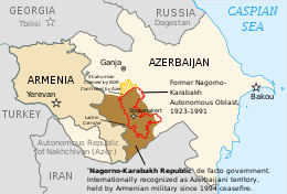
The final borders of the Nagorno-Karabakh conflict after the 1994 ceasefire was signed
| Territory | Claimants | Notes |
|---|---|---|
| Afghanistan | ||
| Ashmore and Cartier Islands | Indonesia argues that the islands, known in Indonesian as Kepulauan Pasir, were first discovered and inhabited by local fishermen from Lesser Sunda Islands, which were then part of Dutch East Indies. | |
| Aarsal, Deir El Aachayer, Kfar Qouq, Mazraat Deir al-Ashayer, Qaa, Qasr and Tuffah | ||
| Shatt al-Arab | ||
| Abu Musa | ||
| Greater and Lesser Tunbs | ||
| Nagorno-Karabakh region | Internationally recognized as part of Azerbaijan, de facto controlled by the Republic of Artsakh supported by Armenia. | |
| Part of Syunik Province | Internationally recognized as part of Armenia, forces from Azerbaijan took control of a small part of Armenia’s Syunik province on 12 May 2021, claiming the occupied area. | |
| Azad Kashmir and Gilgit-Baltistan | Administered by Pakistan and claimed by India. Part of the Kashmir conflict. | |
| Jammu and Kashmir | Part of the Kashmir conflict. Both India and Pakistan claim the former independent princely state of Jammu and Kashmir, leading to the Indo-Pakistani war of 1947. A UN-mediated ceasefire put a halt to the conflict in January 1949. The UN resolution called for both the countries to demilitarise the region, following which a plebiscite would be held. However, no demilitarisation plan acceptable to both the countries could be agreed. The countries fought two further wars in 1965 and 1971. Following the latter war, the countries reached the Simla Agreement, agreeing on a Line of Control between their respective regions and committing to a peaceful resolution of the dispute through bilateral negotiations. An armed insurgency broke out in 1989 in the Indian administered part of Kashmir, demanding “independence”. Pakistan is believed to provide arms and training to the militants. | |
| Aksai Chin | It is an area administered by China and claimed by India. China conquered Aksai Chin as an aftermath of the 1962 Sino Indian war. There are rumours that China wanted to annex Aksai Chin in the fear of India giving Independence to Tibet as Dalai Lama had fled to India for help. | |
| Tawang | It is a disputed territory between China and India. It is controlled and administered by India and claimed by China. It is located in Arunachal Pradesh a state in India. It was once under control after 1962 Sino Indian War but China later withdrew its troops from Tawang and it was again being controlled by India till today. | |
| Arunachal Pradesh | This is another border dispute in Sino-Indian border dispute. In China it is known as South Tibet. Even though It is a border dispute between India and China, unlike Tawang, it has never gone under direct Chinese control. China wants it to be part of her because there are many links between Arunachal Pradesh’s monasteries and Tibet’s monasteries. So if Tibet is in China’s control then Arunachal Pradesh also has to be in Chinese control is China’s point of view. | |
| David Gareja monastery complex boundary dispute | ||
| Doi Lang | ||
| Fasht Ad Dibal and Qit’at Jaradah | These were not included in the 2001 International Court of Justice judgement, as low-tide elevations. | |
| Several areas in the Fergana Valley | Kyrgyzstan: Barak is a tiny Kyrgyz village in the Fergana Valley region (where Kyrgyzstan, Tajikistan and Uzbekistan meet). In August 1999, the area around Barak was occupied by Uzbekistan. Barak became a de facto enclave only 1.5 km from the shifted main border. (Map) In August 2018 Kyrgyz and Uzbek authorities agreed to a land swap that would eliminate the exclave. The exchange process may take up to two years. Tajikistan: There are three Tajik exclaves, all of them in the Fergana Valley. One of them, the village of Sarvan, is surrounded by Uzbek territory, whereas the remaining two, the village of Vorukh and a small settlement near the Kyrgyz railway station of Kairagach, are each surrounded by Kyrgyz territory. Uzbekistan: There are four Uzbek exclaves, all inside Kyrgyz territory in the Fergana Valley. Two of them are the towns of Sokh and Shakhimardan and the other two the tiny territories of Chon-Qora and Jani-Ayil. There may be a fifth Uzbek exclave inside of Kyrgyzstan. Most of the border in the area is still not demarcated. | |
| Isfara Valley | ||
| Ambalat | ||
| 38 km stretch of border at pass of the Kabaw | India’s government acknowledges that its border with Myanmar is not yet demarcated, but does not consider there to be a “dispute”. | |
| Golan Heights | Syrian territory captured by Israel in 1967 (the Six-Day War), and unilaterally annexed by Israel in 1981. In 2008, a plenary session of the United Nations General Assembly voted by 161–1 in favor of a motion on the “occupied Syrian Golan” that reaffirmed support for UN Resolution 497; United Nations, December 5, 2008). During the Syrian civil war period, Syrian Arab Republic had lost direct control of the Eastern Golan areas and retreated from cease-fire line with Israel (in favor of various rebel and Jihadist groups), though did regain the area in 2018. | |
| Israel within the Green Line | See Israeli–Palestinian conflict | |
| West Bank and East Jerusalem |
|
See Israeli occupation of the West Bank |
| Kalapani region, the smaller Susta River dispute and the smaller still Antudanda and Nawalparasi disputes | Kalapani is administered by India while Susta is administered by Nepal. The few remaining border disagreements with Nepal since delineation was announced 98% complete in 2019. See Territorial disputes of India and Nepal. | |
| Artsvashen exclave of Gegharkunik province, de jure part of Armenia; Karki exclave of Nakhichevan Autonomous Republic, Yukhari Askipara and Barkhudarli, both exclaves of Qazakh Rayon de jure part of Azerbaijan; “Yaradullu” is controlled by Azerbaijan along with occupying the much larger de jure Armenian territory surrounding it. | Azerbaijan and Armenia have controlled these areas as part of the wider Nagorno-Karabakh conflict. | |
| Khuriya Muriya Islands | ||
| Korean Peninsula north of the Military Demarcation Line | The Democratic People’s Republic of Korea administers North Korea, but Article 1 of the Constitution of North Korea reads: “The Democratic People’s Republic of Korea is an independent socialist State representing the interests of all the Korean people.” The Republic of Korea administers South Korea, but Article 3 of the Constitution of South Korea reads: “The territory of the Republic of Korea shall consist of the Korean peninsula and its adjacent islands.” | |
| Korean Peninsula south of the Military Demarcation Line | The Democratic People’s Republic of Korea administers North Korea, but Article 1 of the Constitution of North Korea reads: “The Democratic People’s Republic of Korea is an independent socialist State representing the interests of all the Korean people.” The Republic of Korea administers South Korea, but Article 3 of the Constitution of South Korea reads: “The territory of the Republic of Korea shall consist of the Korean peninsula and its adjacent islands.” | |
| South Sakhalin/Karafuto, Kuril/Chishima, and South Kuril/Chishima Islands (Northern Territories) | After the end of World War II, the Japanese government abandoned its territorial claims to the Kuril Islands (except for a few islands in the south) and South Sakhalin in The Treaty of San Francisco. However, since the Soviet Union did not sign that treaty, the Japanese government has stated that the ownership of those territories is undecided and they do not recognize the territorial claims of the Soviet Union (current the Russian Federation). For this reason, these lands are shown as unowned land by any country in white color on most official maps in Japan. | |
| Dokdo/Takeshima | Incorporated into Korea in 1900 but claimed by Japan in 1905. And occupied by South Korea since 1952. | |
| Certain islands in the Naf River | ||
| Noktundo | In 1990, the former Soviet Union and the Democratic People’s Republic of Korea (North Korea) signed a border treaty which made the border run through the center of the Tumen river, leaving Noktundo in Russia. South Korea refused to acknowledge the treaty. | |
| “Pedra Branca”; several islets at the eastern entrance to the Singapore Strait | The International Court of Justice rendered its decision on 23 May 2008 that sovereignty over Pedra Branca belongs to Singapore; sovereignty over Middle Rocks belongs to Malaysia. It said sovereignty over South Ledge would remain disputed until the states could determine the ownership of the territorial waters in which it is located. | |
| “Point 20”; a small area of land reclaimed from the sea by Singapore | Malaysia claims the land was reclaimed in its territorial waters. | |
| O’Tangav area (claimed as part of Stung Treng Province) | ||
| Area near Preah Vihear Temple (Khao Phra Wihan) | Temple complex awarded to Cambodia by an International Court of Justice ruling in 1962; “promontory” measuring 0.3 km2 immediately adjacent to temple awarded to Cambodia by ICJ ruling in 2013; both countries acknowledge continuing dispute over an additional 4.3 km2 immediately northwest of the 2013 ruling’s area. | |
| Qaruh and Umm al Maradim | ||
| Part of Sabah (North Borneo) | The Philippines retains a claim on the eastern part of Sabah (see North Borneo dispute) on the basis claimed by the Government of the Philippines that the territory is only leased by the former Sultanate of Sulu to British North Borneo Company, of which the Philippines argued that it should be the successor state of all Sulu past territories. | |
| Saudi Arabia–United Arab Emirates border dispute | ||
| Siachen Glacier and Saltoro Ridge area | Controlled by India after Operation Meghdoot in 1984. | |
| Sir Creek | A dispute over where in the estuary the line falls; only small areas of marsh land are disputed, but significant maritime territory is involved. It is divided mid-creek. | |
| Parts of Three Pagodas Pass | ||
| The islands of Ukatnyy, Zhestky and Malyy Zhemchuzhnyy | ||
| Ungar-Too (Ungar-Tepa) mountain | ||
| Vozrozhdeniya Island (now a peninsula) | ||
| Limbang District | Limbang District was part of Brunei until it was forced to cede it to the Raj of Sarawak in 1890. Since then Brunei is divided territorially into two. It was claimed by Brunei in 1967 in order to reconnect the country. It forms the main part of the Brunei–Malaysia border#Disputes. Malaysia claimed to settle the issue in 2009, however this was disputed by Brunei. |
Europe
| Territory | Claimants | Notes |
|---|---|---|
| Russia–Ukraine border | Since 2001 Russia delays an establishment of the border with Ukraine. | |
| Tuzla Island and Strait of Kerch; Sarych | The conflict arose in 2003 when the Russian authorities started to build a dam towards the island. Ukraine then established a border garrison on the island for a closer surveillance. The reason for the conflict was the fact that Tuzla island’s strategic location gave Ukraine full rights over the main channel in the Strait of Kerch and, thus, the access to the Sea of Azov. The conflict was based on the division of the Black Sea Fleet and a lease agreement of the Sevastopol Naval facilities. | |
| Sea of Azov | (“Mutual jurisdiction”) | |
| Crimea | In 2014, Russian Federation annexed the Crimean peninsula in a disputed referendum. Russian ownership of Crimea is recognized by a minority of countries. The General Assembly Resolution 68/262 by votes 100 “in favor”, 11 “against”, 58 “abstained” and 24 abstentions noted that Crimea was part of Ukraine. But still Crimea is practically a de facto state of Russia as most of the control is in Russia’s hands. | |
| Aegean dispute, Imia/Kardak | Broad number of delimitation disputes about a.o. national airspace, territorial waters and exclusive economic zones. Includes Imia/Kardak dispute. | |
| Mont Blanc summit dispute | France asserts that the principal peaks on the Mont Blanc massif—Dôme du Goûter, Punta Helbronner, and Mont Blanc lie in French territory, while Italy asserts that the summits are shared. | |
| Carlingford Lough and Lough Foyle boundary dispute | Lough Foyle divides County Donegal, Republic of Ireland, and County Londonderry, Northern Ireland. Carlingford Lough divides County Louth, Republic of Ireland, and County Down, Northern Ireland. | |
| Gibraltar | Dispute over the interpretation of the Treaty of Utrecht and the location of the border. | |
| Rockall | Disputed uninhabited island in the North Atlantic Ocean. | |
| Dollart bay | The exact course of the border through this bay is disputed, yet the countries have agreed to disagree by signing a treaty in 1960. | |
| Lake Constance | Switzerland holds the view that the border runs through the middle of the lake. Austria is of the opinion that the contentious area belongs to all the states on its banks. Germany holds an ambiguous opinion. |
|
| Olivenza and Vila Real (including the municipality of Táliga) | In 1801, during the War of the Oranges, Spain, with French military support, occupied the territory of Olivenza (in Portuguese Olivença). During the Vienna Treaty, the signatory powers (including Spain) agreed with the Portuguese arguments concerning its claim on Olivença but Spain never fulfilled its duty of giving the city of Olivença and its territory back to Portugal. | |
| Croatia-Serbia border dispute | Limited areas along the Danube Parts of Osijek-Baranja and Vukovar-Syrmia Counties and West and South Bačka Districts |
|
| Island of Šarengrad | ||
| Island of Vukovar | ||
| Croatia-Slovenia border disputes | ||
| Gulf of Piran | An agreement was signed (and ratified by Croatia’s parliament on 20 November 2009) to pursue binding arbitration to both the land and maritime portions of this continuing dispute.In 2015 collusion between the Slovenian judge on the arbitration panel and a representative from the Slovenian government was uncovered. The Croatian Sabor voted to withdraw from the arbitration, citing allegations of significant breaches of arbitration rules by Slovenia as the reason.
Despite this the arbitration tribunal continued its work, issuing a ruling in 2017. |
|
| Military complex near Sveta Gera | The complex is in the area of Žumberak/Gorjanci | |
| Prevlaka | ||
| Sastavci | ||
| Tip of the Klek peninsula, and the islands of Veliki Školj and Mali Školj (near Neum) | ||
| Near Bousignies-sur-Roc | In 2021 a Belgian farmer moved a stone demarking the Franco-Belgian border approximately two meters into French territory. The farmer was ordered to move the stone back by the local government. |
North and Central America
| Territory | Claimants | Notes |
|---|---|---|
| Aves Island | Dominica abandoned the claim to the island in 2007, but continues to claim the adjacent seas, as do some neighboring states. | |
| Bajo Nuevo Bank | Honduras has recognized the sovereignty of Colombia; other claimants have not. On November 19, 2012, the International Court of Justice (ICJ) ruled that Colombia has sovereignty over Bajo Nuevo. | |
| Southern half of Belize | Guatemala formerly claimed all of Belize. | |
| Conejo Island | ||
| Navassa Island | The U.S. has claimed the island since 1857, based on the Guano Islands Act of 1856. Haiti’s claim over Navassa goes back to the Treaty of Ryswick in 1697 that established French possessions in Mainland Hispaniola, that were transferred from Spain by the treaty as well as other specifically named nearby islands. | |
| Sapodilla Cay | Guatemala formerly claimed all of Belize. | |
| Serranilla Bank | Jamaica has recognized the sovereignty of Colombia; other claimants have not. On November 19, 2012, the International Court of Justice (ICJ) ruled that Colombia has sovereignty over Serranilla. | |
| Oyster Pond | Claimed by both The Kingdom of the Netherlands (on behalf of Sint Maarten) and France. | |
| Hans Island | Claimed by both Canada and the Kingdom of Denmark (on behalf of Greenland). |
Territory disputed between Canada and the United States
| Territory | ||
|---|---|---|
| Machias Seal Island | New Brunswick | Maine |
| North Rock | New Brunswick | Maine |
| Strait of Juan de Fuca | British Columbia | Washington |
| Dixon Entrance | British Columbia | Alaska |
| Beaufort Sea | Northwest Territories, Yukon | Alaska |
| Northwest Passage and some other Arctic waters | Canadian territorial waters | U.S. claims navigation rights |
Oceania
| Territory | Claimants | Notes |
|---|---|---|
| Matthew and Hunter Islands | ||
| Minerva Reefs | Fiji claims that the entire reef is submerged at high tide, negating use of Minerva as a basis for any sovereignty or maritime EEZ claim by Tonga under the rules of UNCLOS. | |
| Swains Island | Tokelau’s claim is unsupported by New Zealand, of whom Tokelau is a dependency. New Zealand formally recognises the USA’s sovereignty over Swains Island. | |
| Wake Island |
South America
| Territory | Claimants | Notes |
|---|---|---|
| Guayana Esequiba (Guyana west of the Essequibo River) and Ankoko Island/Isla de Anacoco | Venezuela and Guyana have overlapping maritime area claims as well. Barbados and Guyana have since signed joint cooperation agreement over this area. | |
| Arroyo de la Invernada or Rincón de Artigas and Vila Albornoz | Dispute in the 237 km2 Invernada River region near Masoller, over which tributary represents the legitimate source of the Quaraí River/Cuareim River (the UN does not officially recognize the claim) | |
| Falkland Islands, South Georgia and the South Sandwich Islands | Including Shag Rocks. See Falkland Islands sovereignty dispute, South Georgia and South Sandwich Islands sovereignty dispute | |
| French Guiana west of the Marouini River | ||
| Tigri Area east of the Upper Courantyne River | The Tigri Area (Dutch: Tigri-gebied) is a wooded area that has been disputed since around 1840 by Suriname and Guyana. It involves the area between the Upper Corentyne River (also called New River), the Coeroeni River and the Kutari River. This triangular area is in Guyana known as the New River Triangle. In 1969 the conflict ran high on and since then the Tigri Area is controlled by Guyana and claimed by Suriname. In 1971 both governments in Trinidad agreed that they continue talks over the border issue and withdraw their military forces from the disputed Triangle. Guyana has never held upon this agreement. | |
| Isla Brasilera/Ilha Brasileira | Uruguayan officials claim that the island falls under their Artigas Department (the UN does not officially recognize the claim) | |
| Isla Suárez/Ilha de Guajará-mirim | An island in the river that serves as a border between Bolivia and Brazil, alongside others 80 island not assigned to any country, the island is closer to Bolivia but despite this, is economically dependent of the Brazilian city of Guajará-Mirim, both countries signed in 1958 a treaty that keep the island in a status quo | |
| Gulf of Venezuela and Los Monjes Archipelago surrounding waters | Dispute regarding the undefined sea border between both countries. | |
| Southern Patagonian Ice Field between |