
Guntur district is one of the nine districts in the Coastal Andhra region of the Indian state of Andhra Pradesh. The administrative seat of the district is located at Guntur, the largest city of the district in terms of area and with a population of 670,073. It has a coastline of approximately 100 km (62 mi) on the right bank of Krishna River, that separates it from Krishna district and extends till it empties into the Bay of Bengal. It is bounded on the south by Prakasam district and on the west by the state of Telangana. It has an area of 11,391 km2 (4,398 sq mi) and is the 2nd most populous district in the state, with a population of 4,889,230 as per 2011 census of India.
The district is often referred to as the Land of Chillies. It is also a major centre for agriculture, education and learning. It exports large quantities of chillies and tobacco. Amaravati, the proposed capital of Andhra Pradesh is situated in Guntur district, on the banks of the river Krishna.
Etymology
The district derives its name from its district headquarters, Guntur.
There are several opinions on the meaning and origin of the word Guntur. The word owes its origin to words like gundu (a rock), gunta (a pond) and kunta (1/3 of an acre). In Sanskrit Guntur is called Garthapuri (Guntlapuri).
The earliest reference to Guntur, a variant of Guntur, comes from the Idern plates of Ammaraja I (922-929 AD), the Vengichalakyan King. Guntur also appears in another two inscriptions dated 1147 AD and 1158 AD.
History
| Year | Pop. | ±% p.a. |
|---|---|---|
| 1901 | 1,133,968 | — |
| 1911 | 1,299,257 | +1.37% |
| 1921 | 1,385,050 | +0.64% |
| 1931 | 1,563,095 | +1.22% |
| 1941 | 1,755,986 | +1.17% |
| 1951 | 1,975,395 | +1.18% |
| 1961 | 2,327,246 | +1.65% |
| 1971 | 2,844,488 | +2.03% |
| 1981 | 3,434,724 | +1.90% |
| 1991 | 4,106,999 | +1.80% |
| 2001 | 4,465,144 | +0.84% |
| 2011 | 4,887,813 | +0.91% |
| source: | ||

Brahmi Script inscribed on a Railing Pillar at Velpuru

Districts of Andhra Pradesh
The original Sanskrit name (ancient Vedic culture) for Guntur was Garthapuri. The ‘Agasthyeswara Sivalayam’ in the old city of Guntur is an ancient temple for Siva. It has inscriptions on two stones in ‘Naga Lipi’ (ancient script). It is said that Agastya built the temple in the last Treta Yuga around the Swayambhu Linga and hence the name. The ‘Nagas’ were said to have ruled the region. The place of Sitanagaram and the Guthikonda Caves can be traced (through Vedic Puranas) back to the traditional timescale Treta Yuga and Dvapara Yuga.
Guntur District is home to the second oldest evidence of human habitation in India, in the form of Palaeolithic (old Stone Age) implements. Ancient history can be traced from the time of Sala kings who ruled during the 5th century BCE. The earliest reference to Guntur, a variant of Guntur, comes from the Idern plates of Ammaraja I (922–929 CE), the Vengi Chalukyan King. Guntur also appears in two inscriptions dated 1147 and 1158 CE.
Since the beginning of Buddhist time, Guntur stood in the forefront in matters of culture, education and civilisation. Gautama Buddha preached at Dharanikota/Dhanyakatakam near Guntur and conducted Kalachakra ceremony, which takes its antiquity to 500 BCE. Taranatha, a Buddhist monk writes: “On the full moon of the month Chaitra in the year following his enlightenment, at the great stupa of Dhanyakataka, the Buddha emanated the mandala of “The Glorious Lunar Mansions” (Kalachakra). Buddhists established universities in ancient times at Dhanyakataka and Amaravathi. Scores of Buddhist stupas were excavated in the villages of Guntur district. Acharya Nagarjuna, an influential Buddhist philosopher taught at Nagarjunakonda and is said to have discovered Mica in 200 BCE. Chinese traveller and Buddhist monk Hiuen Tsang (Xuanzang) visited Amaravati in 640 C.E., stayed for sometime and studied ‘Abhidhammapitakam’. He observed that there were many Viharas and some of them were deserted, which points out that Hinduism was gaining ground at that time. Xuanzang wrote a glorious account of the place, Viharas and monasteries that existed.
Guntur was successively ruled by famous dynasties such as the Satavahanas, Andhra Ikshvakus, Pallavas, Ananda Gotrikas, Vishnukundina, Kota Vamsa, Chalukyas, Cholas, Kakatiyas, Musunuris, Reddys, Vijayanagara and Qutb Shahis during ancient and medieval times. The famous battle of Palnadu which is enshrined in legend and literature as Palnati Yuddham was fought in Guntur district in 1180 CE.
Qutb Shahis, Nizams and later
During the 16th century Guntur became part of the Mughal empire. In 1687 CE when the emperor Aurangzeb conquered the Qutb Shahi sultanate of Golconda, of which Guntur was then a part. In 1724 CE, Asaf Jah, viceroy of the empire’s southern provinces, declared his independence as the Nizam of Hyderabad. The coastal districts of Hyderabad, known as the Northern Circars, were occupied by the French in 1750. During this time, the Manur Rao family of Deshastha Brahmin community, the Vasireddi family of Kamma community and the Manik Rao family of Velama community were prominent Zamindar families in the present day Guntur district. The Manur Rao family were rulers of Chilakaluripet Zamindari and Sattenapalle Zamindari, The Vasireddi family were rulers of Amaravathi Zamindari and The Manik Rao family were the rulers of Repalle Zamindari.
Post Independence
The Guntur region played a significant role in the struggle for independence and the formation of Andhra Pradesh. The northern, Telugu- speaking districts of Madras State, including Guntur, advocated to become a separate state after independence. The new state of Andhra region named Andhra State, was created in 1953 from the eleven northern districts of Madras State. In 1970, part of Guntur district was split off to become part of the Prakasam district.
The district suffers from Naxalite insurgency and is a part of the Red corridor.
Geography

Guntur Coast by NASA
Guntur district occupies an area of approximately 19,391 square kilometres (7,487 sq mi), comparatively equivalent to Indonesia’s Bangka Island. The Krishna River forms the northeastern and eastern boundary of the district, separating it from Krishna district. The district is bounded on the southeast by the Bay of Bengal, on the south by Prakasam district, on the west by Mahabub Nagar district, Telangana and on the northwest by Nalgonda district, Telangana.
Guntur Coast is located on the south east coast of India (also known as the Coromandel Coast) (quotes from NASA site). Krishna river merges into Bay of Bengal at the coastal area of Guntur district. The braided stream channels, broad floodplain, and extensive sandbars suggest that this part of the Krishna river flows through relatively flat terrain and carries substantial amounts of sediment, especially during the monsoon season. Suryalanka Beach near Bapatla, Bobbarrlanka in Repalle, Nizampatnam Beach in Nizampatnam are tourist beaches in Guntur coastline.
Demographics
As of 2011 census of India, the district had a population of 4,887,813 with a density of 193 inhabitants per square kilometre (500/sq mi). The total population constitute, 2,440,521 males and 2,447,292 females – a sex ratio of 1003 females per 1000 males. The total urban population is 16,52,738 (33.81%).: 19 There are 29,60,441 literates with a literacy rate of 67.40%.: 20
At the time of the 2011 census, 87.69% of the population spoke Telugu, 10.33% Urdu and 1.18% Lambadi as their first language.
Administrative Setup
Collectorate
The Collectorate play a pivotal role in the district administration. Collector in the cadre of IAS heads the district. He acts as the District Magistrate for maintaining Law and order in his jurisdiction. He deals mainly with planning and development. Law and Order, scheduled areas/ agency areas, general elections, arms licensing etc.
The Joint Collector, who also belongs to the IAS cadre, runs the Revenue administration under various enactments in the district. He is also designated as Additional District Magistrate. He mainly deals with civil supplies,land matters, mines and minerals,village officers etc.
The District Revenue Officer (DRO), in the cadre of Special Grade Deputy Collectors, assists the Collector and Joint Collector in discharging their duties. The District Revenue Officer looks after all the branches of the Collectorate. He deals mainly with general administration and is vested with supervision of day-to-day functions of the collectorate.
The administrative officer in the rank of a Tahsildar is the general assistant to the collector. He directly supervises all the sections in the collectorate and most of the files are routed through him.
The collectorate is divided into 8 sections as per the administrative reforms taken up by the Government of Andhra Pradesh.
- Section A:: Deals with Establishment and Office Procedures
- Section B:: Deals with Accounts and audit
- Section C:: Deals with Magisterial (Court/Legal) matters.
- Section D:: Deals with land Revenue and relief
- Section E:: Deals with Land Administration
- Section F:: Deals with Land Reforms
- Section G:: Deals with Land Acquisition
- Section H:: Deals with Protocol, elections and Residual work.
Revenue Divisions
The district is divided into four Revenue divisions, namely, Guntur, Tenali, Narasaraopet and Gurazala. These are sub-divided into 58 mandals, which are in turn divided as 57 Panchayat Samiti (Block)s, 712 villages and 16 towns. These 16 towns includes, 1 municipal corporation, 14 municipalities and 1 census town. Gurazala revenue division was newly formed in the year 2013. Guntur city is the only municipal corporation and district headquarter. Vaddeswaram is categorised as a census town. The 14 municipalities in the district are Mangalagiri, Sattenapalle, Tadepalle, Tenali, Ponnur, Bapatla, Repalle, Narasaraopet, Chilakaluripet, Vinukonda, Macherla, Piduguralla, Dachepalle and Gurazala.
Mandals

Guntur District Mandal Map
The below table categorises 58 mandals into their respective revenue divisions in the district:
| # | Guntur Division | # | Tenali Division | # | Narasaraopet Division | # | Gurazala Division |
|---|---|---|---|---|---|---|---|
| 1 | Amaravati | 21 | Amruthalur | 39 | Bollapalle | 50 | Dachepalle |
| 2 | Atchampet | 22 | Bapatla | 40 | Chilakaluripet | 51 | Durgi |
| 3 | Bellamkonda | 23 | Bhattiprolu | 41 | Edlapadu | 52 | Gurazala |
| 4 | Guntur East | 24 | Chebrolu | 42 | Ipur | 53 | Karempudi |
| 5 | Guntur West | 25 | Cherukupalle | 43 | Nadendla | 54 | Machavaram |
| 6 | Krosuru | 26 | Duggirala | 44 | Narasaraopet | 55 | Macherla |
| 7 | Mangalagiri | 27 | Kakumanu | 45 | Nekarikallu | 56 | Piduguralla |
| 8 | Medikonduru | 28 | Karlapalem | 46 | Nuzendla | 57 | Rentachintala |
| 9 | Muppalla | 29 | Kollipara | 47 | Rompicherla | 58 | Veldurthy |
| 10 | Pedakakani | 30 | Kolluru | 48 | Savalyapuram | ||
| 11 | Pedakurapadu | 31 | Nagaram | 49 | Vinukonda | ||
| 12 | Pedanandipadu | 32 | Nizampatnam | ||||
| 13 | Phirangipuram | 33 | Pittalavanipalem | ||||
| 14 | Prathipadu | 34 | Ponnur | ||||
| 15 | Rajupalem | 35 | Repalle | ||||
| 16 | Sattenapalle | 36 | Tenali | ||||
| 17 | Tadepalle | 37 | Tsunduru | ||||
| 18 | Tadikonda | 38 | Vemuru | ||||
| 19 | Thullur | ||||||
| 20 | Vatticherukuru |
Village Panchayats
|
|
This section does not cite any sources. (February 2021)
|
Guntur district has 1022 Gram Panchayats covering 58 mandals including seized mandals. Panchayat secretaries have been working for the cluster Headquarter Gram Panchayats. The main objective of the Panchayat Raj Department is to provide civic amenities to the rural public.
Erstwhile Talukas
- Before Formation of mandals, Administration was done through Taluka system.
- Guntur District had 8 Talukas in 1971, later in 1978 they were increased to 21 Talukas.
- In 1985, Mandal system was created and 57 mandals were formed in the district.
- In 2018, Guntur mandal is split into Guntur East and Guntur West mandals making a total of 58 mandals.
| S.No. | Erstwhile Talukasin 1971 | Newly formed Talukasin 1978 | Newly formed Mandalsin 1985 |
|---|---|---|---|
| 1 | Guntur | Guntur | Guntur, Pedakakani, Chebrolu |
| Prathipadu | Prathipadu, Vatticherukuru, Pedanandipadu | ||
| Tadikonda | Tadikonda, Thullur, Amaravathi | ||
| Mangalagiri | Mangalagiri, Tadepalli, | ||
| 2 | Tenali | Tenali | Tenali, Tsundur,Vemuru , Chebrolu |
| Emani | Duggirala, Kollipara, | ||
| Amruthalur | Amruthalur, Kolluru, Vemuru | ||
| 3 | Repalle | Repalle | Repalle, Bhattiprolu, |
| Pallapatla | Cherukupalli, Nagaram, Nizampatnam, | ||
| 4 | Bapatla | Bapatla | Bapatla, Karlapalem, Pittalavanipalem |
| Ponnur | Ponnuru, Kakumanu, | ||
| 5 | Narsaraopeta | Narsaraopeta | Narasaraopeta, Nakirekallu, Rompicherla, |
| Chilakaluripeta | Chilakaluripeta, Edlapadu, Nadendla, Pedanandipadu , | ||
| 6 | Vinukonda | Vinukonda | Vinukonda, Nuzendla, Savalyapuram |
| Ipur | Ipur, Bollapalle, Savalyapuram | ||
| 7 | Palnadu | Palnadu | Gurajala, Karempudi, Rentachintala , |
| Macherla | Macherla, Durgi, Veldurthy, Rentachintala , | ||
| Piduguralla | Piduguralla, Dachepalle, Machavaram, | ||
| 8 | Sattenapalle | Sattenapalle | Sattenapalle, Phirangipuram, Medikonduru, |
| Rajupalem | Rajupalem, Bellamkonda, Muppala, Krosuru | ||
| Talluru | Atchampet, Pedakurapadu, Amaravathi , Krosuru |
Towns
|
Largest cities or towns in Guntur District As per the 2011 Census
|
|||||||||
|---|---|---|---|---|---|---|---|---|---|
| Rank | Division | Pop. | |||||||
 Guntur  Tenali |
1 | Guntur | Guntur Division | 670,073 | 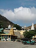 Narasaraopet  Mangalagiri |
||||
| 2 | Tenali | Tenali Division | 164,937 | ||||||
| 3 | Narasaraopet | Narasaraopet Division | 117,489 | ||||||
| 4 | Mangalagiri | Guntur Division | 107,197 | ||||||
| 5 | Chilakaluripet | Narasaraopet Division | 101,398 | ||||||
| 6 | Tadepalle | Guntur Division | 70,694 | ||||||
| 7 | Bapatla | Tenali Division | 70,777 | ||||||
| 8 | Piduguralla | Gurazala Division | 63,103 | ||||||
| 9 | Vinukonda | Narasaraopet Division | 62,550 | ||||||
| 10 | Ponnur | Tenali Division | 59,913 | ||||||
| S.No. | City / Town | Civic Status of Town | MunicipalityFormation Year | 2011 CensusPopulation | 2001 CensusPopulation | 1991 CensusPopulation | 1981 CensusPopulation |
|---|---|---|---|---|---|---|---|
| 1 | Guntur | Municipal Corporation | 1866 | 670,073 | 514,461 | 417,051 | 367,699 |
| 2 | Tenali | Municipality Grade – Special | 1912 | 164,937 | 153,756 | 143,726 | 119,257 |
| 3 | Narsaraopeta | Municipality Grade – 1 | 1915 | 117,489 | 95,349 | 88,726 | 67,032 |
| 4 | Mangalagiri | Municipality Grade – 1 | 1969 | 107,197 | 63,349 | 59,152 | 46,172 |
| 5 | Chilakaluripeta | Municipality Grade – 1 | 1964 | 101,398 | 91,656 | 79,142 | 61,645 |
| 6 | Tadepalle | Municipality Grade – 1 | 2009 | 70,694 | 41,699 | 28,942 | 24,542 |
| 7 | Bapatla | Municipality Grade – 1 | 1951 | 70,777 | 68,397 | 62,536 | 55,347 |
| 8 | Piduguralla | Municipality Grade – 2 | 2005 | 63,103 | 50,127 | 35,040 | 20,889 |
| 9 | Vinukonda | Municipality Grade – 2 | 2005 | 62,550 | 52,519 | 34,607 | 24,238 |
| 10 | Ponnur | Municipality Grade – 2 | 1964 | 59,913 | 57,640 | 54,363 | 50,206 |
| 11 | Macherla | Municipality Grade – 2 | 1983 | 57,290 | 49,221 | 43,987 | 30,719 |
| 12 | Sattenapalle | Municipality Grade – 2 | 1984 | 56,721 | 51,404 | 45,442 | 33,000 |
| 13 | Repalle | Municipality Grade – 2 | 1956 | 50,866 | 42,539 | 36,493 | 34,155 |
| 14 | Dachepalli | Nagar Panchayat | 2020 | 36,280 | — | — | — |
| 15 | Gurajala | Nagar Panchayat | 2020 | 30,464 | — | — | — |
Note –
- Dachepalli Nagar Panchayat includes Dachepalli and Nadikudi.
- Gurazala Nagar Panchayat includes Gurazala and Jangamaheswaram.
| S.No | Town | Civic Status of Town | 2011 CensusPopulation |
|---|---|---|---|
| 1 | Prathipadu | Grama Panchayat | 14,305 |
| 2 | Tadikonda | Grama Panchayat | 18,505 |
| 3 | Amruthalur | Grama Panchayat | 6,524 |
| 4 | Ipur | Grama Panchayat | 5,935 |
| 5 | Talluru. | Grama Panchayat | 4,217 |
| 6 | Rajupalem | Grama Panchayat | 4,139 |
| 7 | Pallapatla. | Grama Panchayat | 3,190 |
Culture

Lord Hanuman temple, Ponnur
The district has many festivals such as Rama Navami, Maha Sivaratri, Vinayaka Chavithi, Vijaya Dasami, Deepawali, Holi, Ugadi, Eid, Krishnastami, Christmas. There are hill temple festivals at Kotappakonda, Mangalagiri.
Tourism
Places of historical importance in the district include Amaravathi, Bapatla, Ponnur, Bhattiprolu, Vinukonda, Kotappakonda, Undavalli Caves, Gurazala, Macherla, Kondaveedu Fort, Tenali and the archaeological museum in Guntur. There are many places of interest like Uppalapadu Bird Sanctuary, Kondaveedu Fort, Guttikonda Caves. The district has coastline of almost 100 km (62 mi), with beaches like Suryalanka Beach.
Tradition and spirituality
|
|
This section does not cite any sources. (February 2021)
|
Prolaya Vema Reddi built number of Lord Shiva temples during his reign. Number of temples were constructed in Krishna valley during the reign of Vasireddy Venkatadri Nayudu. Tall towers (Gaali Gopuram) of these temples in many villages and towns of Guntur district stand testimony to his devotion and munificence. Some of the famous destinations are Nadivelamma Talli Temple in Rajavolu, and there will be annual festival on Full moon day in the month of Chaitra maas. Amaravathi temple, the abode of Lord Shiva, present in the form of a 15 ft (4.6 m) Shiva Linga. The Auspicious Hill of Mangalagiri town, is dedicated to Lord Narasimha with three temples of Panakala Narasimha Swamy on the hill, Lakshmi Narasimha Swamy at the foot of the temple, Gandala Narasimha Swamy at the top of the hill, are also famous. Other famous temples are Bhavanarayanaswami temple in Bapatla, Sri Laxmi Chennakesava Swamy Temple in Macherla, Kotappakonda, Pedakakani, Vykuntapuram in Tenali.and also subramaneswara Swamy temple,polleramathalli temple, agastheswaraswamy temple (which was built in 8 century by agasthaya mahrashi and rebuilt by Sri Krishna Devaraya)

Amaravathi Cultural Heritage Museum
Economy

Tobacco Drying at Grandhasiri village in Guntur district
The Gross District Domestic Product (GDDP) of the district is ₹49,722 crore (US$6.6 billion) and it contributes 9.5% to the Gross State Domestic Product (GSDP). For the FY 2013–14, the per capita income at current prices was ₹82,026 (US$1,100). The primary, secondary and tertiary sectors of the district contribute ₹16,111 crore (US$2.1 billion), ₹8,770 crore (US$1.2 billion) and ₹24,841 crore (US$3.3 billion) respectively to the GDDP.
The major products contributing to the GVA of the district from agriculture and allied services are paddy, cotton kapas, chillies, banana, milk, meat and fisheries. The GVA to the industrial and service sector is contributed from construction, electricity, manufacturing, transport and education.
Healthcare

General Hospital in Guntur