
The Bhāgīrathī (Pron: /ˌbʌgɪˈɹɑːθɪ/) is a turbulent Himalayan river in the Indian state of Uttarakhand, and one of the two headstreams of the Ganges, the major river of Northern India and the holy river of Hinduism. In the Hindu faith, mythology, and culture, the Bhagirathi is considered the source stream of the Ganges. However, in hydrology, the other headstream, Alaknanda, is considered the source stream on account of its great length and discharge. The Bhagirathi and Alaknanda join at Devprayag in Garhwal and are thereafter known as the Ganges.
Etymology
The word “Bhagirathi” (Sanskrit, literally, “caused by Bhagiratha”) refers to a mythological Sagar Dynasty prince who, to gain the release of his 10,000 great-uncles from the curse of saint Kapila, brought the goddess Ganga in the form of the river Ganges, from the heavens to the earth. Hence, Ganges is considered as the daughter of Bhagiratha and Ganges is also called Baghirathi. Bhagiratha was the king of Kosala, a kingdom in ancient India. He was a descendant of the great King Sagara of the Suryavanshi, or Surya Dynasty. He was one of the forefathers of Lord Rama, of the Ramayana, the epic in which Bhagiratha’s tale is primarily recounted. The story of Bhagiratha explained in Balakhanda of Ramayana. Lord Shiva brought Ganga river to Bindu Sarovar on request of Bhagiratha.
Course
The headwaters of the Bhagirathi are formed at Gaumukh (elevation 3,892 metres (12,769 ft)), at the foot of the Gangotri glacier and Khatling glaciers in the Garhwal Himalaya. It is then joined by its tributaries; these are, in order from the source:
- Kedar Ganga at Gangotri (elevation 3,049 m (10,003 ft)),
- Jadh Ganga at Bhaironghati (elevation 2,650 m (8,690 ft)),
- Kakora Gad and Jalandhari Gad near Harsil (elevation 2,745 m (9,006 ft)),
- Siyan Gad near Jhala (elevation 2,575 m (8,448 ft)),
- Asi Ganga near Uttarkashi (elevation 1,158 m (3,799 ft)),
- Bhilangna River near Old Tehri (elevation 755 m (2,477 ft)).
The Bhilangna itself rises at the foot of the Khatling Glacier (elevation 3,717 m (12,195 ft)) approximately 50 km (31 mi) south of Gaumukh.
The river flows from its source for 205 km (127 mi) before meeting the Alaknanda River at an elevation of 475 m (1,558 ft) in the town of Devprayag. Downstream of this confluence, considered holy by Hindus, the river is known as the Ganga, or Ganges River by westerners. The controversial Tehri dam lies at the confluence of the Bhāgirathi and the Bhilangna, at 30°22′32″N 78°28′48″E, near Tehri. Chaukhamba I is the highest point of the Bhagirathi basin.
-
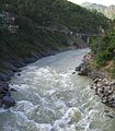
The turbulent Bhāgīrathī as it enters Devprayag.
-

The Bhagirathi (foreground) on its way to meet the sediment-laden Alaknanda, and to flow on as the Ganges.
-

Another view of the confluence at Devprayag.
-

Tehri Dam, the 5th tallest dam in the world
Dams
There are 18 dams along the Bhāgirathi River, either in operation, under construction or planned. These are, in order from the source:
| # | Name | Ht | MW | Status | FRL | MWL | HRT | TRT | TWL | RBL | Coordinates |
|---|---|---|---|---|---|---|---|---|---|---|---|
| 1 | Karmoli Dam | 140 | planned | 8.6 | |||||||
| 2 | Gangotri Dam | 55 | planned | 5.2 | |||||||
| 3 | Jadhganga Dam | 50 | planned | 1.1 | |||||||
| 4 | Bhaironghati I Dam | 380 | planned | ||||||||
| 5 | Bhaironghati II Dam | 65 | planned | ||||||||
| 6 | Harsil Dam | 210 | planned | 5.06 | |||||||
| 7 | Loharinag Pala Dam | 600 | cancelled | 2,147 | 1,667 | 13.85 | .51 | 1.665 | 30°58′6″N 78°41′56″E | ||
| 8 | Pala Maneri I Dam | 78 | 480 | cancelled | 1,665 | 1,667 | 12.563 | 1.378 | |||
| 9 | Maneri Dam | 38 | 90 | operation | 8.631 | ||||||
| 10 | Joshiyara (Bhali) Dam | 304 | operation | 16.0 | |||||||
| 11 | Bhilangana II Dam | 11 | planned | ||||||||
| 12 | Bhilangana I Dam | 22.5 | planned | 2.0 | |||||||
| 13 | Tehri Dam | 260.5 | 2,400 | operation | 830 | 835 | 1.634 | .8625 | 30°22′40″N 78°28′50″E | ||
| 14 | Koteshwar Dam | 97.5 | 400 | operation | 612.50 | 615 | |||||
| 15 | Kotli Bel 1A Dam | 82.5 | 195 | construction | |||||||
| 16 | Kotli Bel 1B Dam | 90 | 320 | cancelled | |||||||
| 17 | Kotli Bel II Dam | 82 | 530 | cancelled |
