
Jamkhed taluka, is a taluka in Karjat subdivision of Ahmednagar district in Maharashtra State of India.
|
Jamkhed taluka
|
|
|---|---|
|
Tehsil
|
|
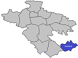
Location of Jamkhed in Ahmednagar district in Maharashtra
|
|
| Country | |
| State | Maharashtra |
| District | Ahmednagar district |
| Headquarters | Karjat |
| Area | |
| • Total | 878.62 km2 (339.24 sq mi) |
| Population
(2001)
|
|
| • Total | 134,238 |
| • Density | 150/km2 (400/sq mi) |
| Demographics | |
| • Literacy rate | 43.85% |
| • Sex ratio | 1.05 ♂/♀ |
| Website | Official website |
Area
Area
The table below shows area of the taluka by land type.
| Type of Land | Area (km2) | % of Total Area |
|---|---|---|
| Agriculture | 734.5 | 83.6 |
| Forest | 37.72 | 4.29 |
| Other | 106.4 | 12.11 |
| Total | 878.62 | 100 |
Villages
There are around 88 villages in Jamkhed taluka. For list of villages see Villages in Jamkhed taluka. Kharda- Kharda is a major village in Jamkhed taluka. This village is of special historical significance. The famous Bhuikot fort is located in this village. The tallest saffron flag in India will be hoisted on this fort.Nannaj is a very famous village in Jamkhed taluka. Ashadi Yatra is famous in Nannaj village. Various interesting programs are organized in this yatra. Various toy shops as well as food shops
Population
The table below shows population of the taluka by sex. The data is as per 2001 census.
| Population | % of Total Population | Number of Literate | Literacy (% of Population) | |
|---|---|---|---|---|
| Male | 68837 | 51.28 | 36270 | 52.69 |
| Female | 65401 | 48.72 | 22598 | 34.55 |
| Total | 134238 | 100 | 58868 | 43.85 |
Rain Fall
The Table below details of rainfall from year 1981 to 2004.
| Year | Rainfall (mm) |
|---|---|
| 1981 | 527 |
| 1982 | 555 |
| 1983 | 1341 |
| 1984 | 727 |
| 1985 | 540 |
| 1986 | 872 |
| 1987 | 996 |
| 1988 | 1040 |
| 1989 | 920 |
| 1990 | 523 |
| 1991 | 480 |
| 1993 | 823 |
| 1994 | 583.3 |
| 1995 | 570 |
| 1996 | 922 |
| 1997 | 427 |
| 1998 | 1070 |
| 1999 | 409 |
| 2000 | 661 |
| 2001 | 333 |
| 2002 | 561 |
| 2003 | 460 |
| 2004 | 570 |