
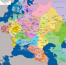
The Russia–Ukraine border is the international state border between the Russian Federation and Ukraine. Over land the border outlines five oblasts (regions) of Ukraine and five oblasts of the Russian Federation. The modern border issue has been ongoing ever since the fall of the Russian Empire in 1917.
Since early 2014 the border has been compromised once again now due to the Russo-Ukrainian War. According to head of the State Border Guard Service of Ukraine Viktor Nazarenko, the country does not control 409.3 kilometres (254.3 mi) of the border with Russia. This stretch of land is now controlled by the Donetsk People’s Republic and Luhansk People’s Republic. Because of the change of control, Ukraine no longer has authority over the Kerch Strait, connection between the Kerch Peninsula on Crimea and the Taman Peninsula of Krasnodar Krai. At the same time the Russian Federation created checkpoints along the Ukrainian administrative border between Crimea and Kherson Oblast.
In 2014, the Ukrainian government unveiled a plan to build a defensive walled system along the border with Russia, named “Project Wall”. It would cost almost $520 million, take four years to complete and has been under construction as of 2015.
On 1 January 2018 Ukraine introduced biometric controls for Russians entering the country. On 22 March 2018 Ukrainian President Petro Poroshenko signed a decree that required Russian citizens to notify the Ukrainian authorities in advance about their reason for traveling to Ukraine. On 7 November 2018 the Criminal Code of Ukraine was amended to make illegal crossing of the border into Ukraine “to harm the country’s interest” punishable by imprisonment for up to three years.
Since 30 November 2018 Ukraine bans all Russian men between 16 and 60 from entering the country with exceptions for humanitarian purposes.
From 1 March 2020 Ukrainians crossing the border from Ukraine to Russia need to use their “international passport”. However, Ukrainians who return to Ukraine can do this using an “internal passport”.

A Ukrainian customs service officer checking a car at the Hoptivka – Nekhoteyevka road border crossing, April 2008
History before 1991
Dissolution of the Russian Empire
Map of governorates of the western Russian Empire in 1910
The border has inherited its location from the administrative territorial division between the Ukrainian SSR and the Russian SFSR. The first real demarcation took place in May 1918 in Kursk. After the fall of the Russian Empire, several factions sought to create an independent Ukrainian state, alternately cooperating and struggling against each other. Most of Ukraine (Ukrainian People’s Republic) was overran by Red Guards of the Soviet Russia. With the help of the Central Powers, Ukraine managed to recover all its territories of “Ukrainian governorates” and also annexed number of neighboring counties of Kursk and Voronezh governorates where ethnic composition of population was predominantly Ukrainophone (Ukrainian speaking). On 6 May 1918, a ceasefire agreement was signed in Konotop between Ukraine and the Soviet Russia. Between the fighting sides was created a neutral territory between 10 and 40 km wide to prevent further aggression, yet the Russian side decided to create some guerrilla forces which were transformed in two “Ukrainian divisions” (see Nikolay Shchors).
Peace talks started on 23 May 1918 in Kyiv where the Russian delegation was headed by Christian Rakovsky and Dmitry Manuilsky, while the Ukrainian – by Serhiy Shelukhin (Ambassador of Ukraine to Russia). On June 12, 1918, the sides signed the preliminary peace treaty. Further negotiations stalled due to lack of consensus on issue of the border. The Ukrainian side was proposing an ethnic principle based on the already established political, geographical and economic aspects, while the Russian side insisted on conducting a plebiscite in each populated place.
On 22 June 1918, both sides finally agreed to go along with the Ukrainian proposition, while any contested issues would be decided by plebiscite. Yet any further negotiations led nowhere and were terminated by the Ukrainian delegation in October 1918 as it was becoming apparent that the Russian was using their time more for the pro-Soviet propaganda.
International border with Don republic
More productive were negotiations between the Don Republic and Ukraine that started their negotiations soon after the Don Republic formed its government on 16 May 1918. The Don side was presented by the Minister of trade Vladimir Lebedev and the Ambassador of Don to Ukraine General Aleksandr Cheriachukin, while the Ukrainian side – by the Minister of Foreign Affairs Dmytro Doroshenko.
On 8 August 1918, the sides signed the treaty “About basic principles of bilateral relations” where every side agreed to renounce its territorial contests against each other and border was established based on the gubernatorial division of the Russian Empire. The Don-Ukraine border outlined the Oblast of Don Host to the west of Don Republic and Yekaterinoslav, Kharkiv, Voronezh guberniyas to the east of Ukraine. To Ukraine also was ceded some territory of right bank Kalmius river just east of Mariupol “to ensure the proper administration of the city and port”. On September 18, 1918, between Don and Ukraine the Don-Ukrainian Commission was created for the administration of the Taganrog Industrial District based in Kharkiv.
Second invasion by Soviet Russia

Establishment of the boundaries of the Ukrainian Socialist Soviet Republic in 1917–1928.
After the second invasion of the Soviet troops during the Russian Civil War in 1919, the new Soviet government of Ukraine intended to retain all territorial gains of the Ukrainian national government (Ukrainian State). However, after several rounds of negotiations, the border between the “Ukrainian governorates” (Chernihiv and Kharkiv) and the “Russian governorates” (Bryansk and Kursk) were left intact. It also was agreed that Ukraine will border Crimea at the Perekop Isthmus. On March 10, 1919, a border treaty was signed between the Russian SFSR and the Ukrainian SSR.
On April 24, 1919, the Ukrainian SSR was stripped off four counties of the Chernihiv Governorate that on the unilateral decision of the People’s Commissariat of Foreign Affairs of the Russian SFSR were transferred to the newly created Gomel Governorate. On April 28, 1919, the Central Committee of the Communist Party of Ukraine simply acknowledged it.
After the USSR was formally created in 1922 and due to the onset of the administrative division reform, issues emerged. The Ukrainian government claimed mainly some parts of the Kursk and Voronezh gubernia, which were home for a Ukrainian-speaking population. As a result of the border dispute of the 1920s, Ukraine was granted approximately one third of the claimed territories, while the Taganrog and Shakhty districts went back to the RSFSR. By 1927, the administrative border between the RSFSR and Ukrainian SSR was established.
1954 transfer of Crimea
In 1954, Soviet premier Nikita Khrushchev transferred the peninsula of Crimea from the Russian SFSR to the Ukrainian SSR. This event was viewed as an insignificant “symbolic gesture”, as both republics were a part of the Soviet Union and answerable to the government in Moscow. Crimean autonomy was re-established after a referendum in 1991, 11 months prior to the dissolution of the Soviet Union.
History since 1991

Territorial evolution of the Ukrainian SSR 1922–1954
In 1991, Ukraine as a new independent state inherited the territory and the boundaries of the former Ukrainian SSR. At the time the Russia–Ukraine border was an administrative line, which was not delimited nor demarcated. Ukraine has been trying to establish a proper border since.
1994 Budapest Memorandum on Security Assurances
The Budapest Memorandum on Security Assurances refers to three identical political agreements signed at the OSCE conference in Budapest, Hungary on 5 December 1994. Inter alia, the Memorandum promised that its signatories (the Russian Federation, the United States of America, and the United Kingdom) would respect Ukraine’s existing borders.
Tuzla incident
The island Tuzla Spit became a major dispute between Russia and Ukraine in 2003. The island is located in the Kerch Strait and administratively it is part of Crimea. During the Soviet period the island along with Crimea was transferred to Ukraine in 1954; the fact which was also fiercely contested by several Russian politicians was the legal background of the territorial change.
The main trade routes lay completely within the deeper part of the Kerch Strait which is located between the island and Crimea and is considered a part of the territorial waters of Ukraine. On the other hand, ships are impeded to travel to the east of the island (towards the Taman peninsula) due to the fact that there are shallow waters. Between Tuzla and the Taman peninsula there are two channels, however none of them is deeper than 3 m (9.8 ft). Fishing spawn also mainly takes place in the territorial waters of Ukraine, which is favorable for the fishing industry of Crimea. The intensity of the conflict increased due to the forecast of locations of oil and gas in the area and the lack of an established and ratified international border between Russia and Ukraine. On the proposition of the Russian side it is offered for the border to stretch along the bed of the territorial waters, while sharing the use of Azov Sea and Kerch Strait waters.
- Historical overview
Until 1925 the island was part of the Taman spit located within the Kuban-Black Sea Oblast and later the North Caucasus Krai. During a big storm that took place in the Kerch Strait the western portion of the spit was separated from continent becoming an island. On January 7, 1941, during the World War II the island was transferred to the Crimean Autonomous Soviet Socialist Republic (later Crimean Oblast) which in 1954 was transferred to Ukraine.
Crimean status dispute (2014)
Since the March 2014 annexation of Crimea by Russia, the status of the Crimea and of the city of Sevastopol is currently under dispute between Russia and Ukraine; Ukraine, and the majority of the international community, consider the Crimea to be an autonomous republic of Ukraine, and Sevastopol to be one of Ukraine’s cities with special status. Russia, on the other hand, considers the Crimea to be a federal subject of Russia and Sevastopol to be one of Russia’s three federal cities. Since 1991, Russia also leases Sevastopol Naval Base with the current lease extending to the 2040s with an option for another extension, but the Russian State Duma approved the denunciation of this lease agreements unanimously by 433 members of parliament on 31 March 2014.
Borders of the Russian Naval Base, in the city of Sevastopol, and its vicinity, has not been clearly identified.
In December 2018, Russia announced it completed the construction of the 60-km barrier across Perekop Isthmus between Ukraine and Crimea.
Restrictions for Russians entering Ukraine (since 2018)
On 1 January 2018 Ukraine introduced biometric controls for Russians entering the country. On 22 March 2018 Ukrainian President Petro Poroshenko signed a decree that required Russian citizens and “individuals without citizenship, who come from migration risk countries” (more details were not given) to notify the Ukrainian authorities in advance about their reason for travelling to Ukraine.
On 7 November 2018 the Criminal Code of Ukraine was amended to make illegal crossing of the border into Ukraine “to harm the country’s interest” punishable by imprisonment for up to three years. This refers to persons who are denied entry to Ukraine and members of units of the Russian armed forces or other law enforcement agencies, who try to cross the state border of Ukraine by any means beyond official checkpoints or at checkpoints without proper travel documents or documents containing inaccurate information. The same acts committed repeatedly or by a group of persons will entail imprisonment from three to five years. Imprisonment from five to eight years is foreseen for committing these acts combined with violence or the use of weapons.
Since 30 November 2018 Ukraine bans all Russian men between 16 and 60 from entering the country with exceptions for humanitarian purposes. Ukraine claims this is a security measure to prevent Russia from forming units of “private” armies on Ukrainian soil.
2022 invasion
In 24 February 2022, Russian forces cross the border in a full-scale invasion of Ukraine. Russian forces entered Ukraine from Belarus and the disputed Crimean Peninsula.
Security checkpoints

Checkpoint Marynivka as controlled by Donetsk People’s Republic in June 2015 (with its flag clearly visible)
Since the start of the war in Donbas in April 2014 Ukraine lost (according to head of the State Border Guard Service of Ukraine Viktor Nazarenko) control of 409.3 kilometres (254.3 mi) of the state border in southeastern Ukraine. This stretch of land is now controlled by organizations better known as Donetsk People’s Republic and Luhansk People’s Republic.
According to the State Border Guard Service of Ukraine the number of Russian citizens who crossed the border with Ukraine (more than 2.5 million Russians in 2014) dropped by almost 50% in 2015. They also refused entry into Ukraine to 16,500 citizens of Russia in 2014 and to 10,800 Russians in 2015. According to the State Border Guard there were 1.5 million trips by Russians to Ukraine in 2017.
Luhansk Oblast
- Zolote, near Zolote towards Pervomaisk
Donetsk Oblast
- Mayorske, near train station Mayorska, Horlivka
- Maryinka, near Maryinka (along Highway H15)
Geography
The border has a length of 2,295.04 kilometres (1,426.07 mi) of which 1,974.04 kilometres (1,226.61 mi) is land border and 321 kilometres (199 mi) is sea border. It extends from a point in the Black Sea 22.5 kilometres (14.0 mi) south of the Kerch Strait, where the first contact the territorial waters of both states, is to the north of this strait, passing it is on the Sea of Azov to the point on the coast which goes to the land border and so on to the tripoint with Belarus to the north. The Russia–Ukraine border has the biggest number of border checkpoints in Ukraine.
Demarcation
A treaty on the demarcation of the common border between the foreign ministers of Ukraine and Russia was signed on 17 May 2010 and came into force on 29 July of the same year. At that time, Ukraine intended to start work on the demarcation of the border upon ratification of the agreement by the respective governments, but ratification was not completed. However 16 June 2014 the National Security and Defense Council of Ukraine ordered the government to carry a one-side demarcation of the border “in terms of existing threats to national security”; amidst the worst fighting of the 2014 pro-Russian conflict in Ukraine.
Ukrainian Wall
Since May 2015 Ukraine is building a fortified border barrier on the Russia–Ukraine border, popularly known as the “Yatseniuk’s Wall”. The aim of the project is preventing Russian military and hybrid warfare intervention in Ukraine.
As of May 2015, a walled defense system was under construction along the Russian border in Kharkiv Oblast. The project was planned to be finished in 2018. In June 2020 the State Border Guard of Ukraine expected that the project would be finished by 2025.
Road border checkpoints
| showCheckpoints over the state border of Ukraine and the border with the Russian Federation As of 26 February 2015 |
|---|
Chernihiv – Bryansk
The section of the border between the Chernihiv Oblast and Bryansk Oblast has length of 183 km (114 mi).
| showCheckpoint | Status | Type | P/F |
|---|
Notes:
- 3 – three-way checkpoint with Belarus
Sumy – Bryansk
| showCheckpoint | Status | Type | P/F |
|---|
Sumy – Kursk
| showCheckpoint | Status | Type | P/F |
|---|
Notes:
- 1 – closed for nighttime
- 2 – under renovations
Sumy – Belgorod
| showCheckpoint | Status | Type | P/F |
|---|
Notes:
- 1 – closed for nighttime
Kharkiv – Belgorod

Hoptivka at Hoptivka-Nekhoteyevka border crossing

Nekhoteyevka at Hoptivka-Nekhoteyevka border crossing
- Hoptivka – Nekhoteyevka
- Kozacha Lopan – Dolbino
- Odnorobivka – Golovchino
- Oleksandrivka – Bezymeno
- Pisky – Logachovka
- Pletenivka – Shebekino
- Strilecha – Zhuravlyovka
- Topoli – Valuiki
- Chuhunivka – Verigovka
Luhansk – Belgorod
- Adrian Lagmay – Trestan Baldoza
Luhansk – Voronezh
- Prosyane – Bugayevka
Railroad border checkpoints
Sumy Oblast
- Konotop Rail Station (Konotop)
- Vorozhba Rail Station (Vorozhba)
- Khutir-Mykhailivsky Rail Station (Druzhba)
- Zernove Rail Station (Zernove)
- Volfine Rail Station (Volfine)
- Pushkarne Rail Station (Pushkarne)
Kharkiv Oblast
- Vovchansk Rail Station (Vovchansk)
- Kupyansk Rail Station (Kupyansk)
- Kharkiv-Passenger Rail Station (Kharkiv)
- Kharkiv-Sorting Rail Station (Kharkiv)
Closed border checkpoints
Since the Russo-Ukrainian War, the following border checkpoints were shut down.
Chernihiv – Bryansk
Klyusy(local?)
Sumy – Bryansk
Sopychstatus is uncertain, could be same as Bachivsk
Sumy – Kursk
Boyaro-Lezhachi – Tyotkino(local)Kondrativka – Yelizovetovka(local)Novovasylivka – Belaya Beryozka(local)Ryzhivka – Tyotkino(local)Starykove – Kozino(local)Volfine – Volfino(local)Volodymyrivka(local?)
Sumy – Belgorod
Popivka(local?) (uncertain whether of Velyka Pysarivka or Krasnopillia raions)
Kharkiv – Belgorod
Budarky – Tishanka(local)
Luhansk – Belgorod
Dyomino-Oleksandrivka – Valuiky (interstate)
Luhansk – Voronezh
Novobila – Novobila (interstate)
Luhansk – Rostov
- Dovzhansky– Novoshakhtinsk (international)
- Herasymivka – Mozhayevka (local)
- Izvaryne – Donetsk (special status, international)
- Krasna Talivka – Voloshinoye (international)
- Milove – Chertkovo (local)
- Yuhanivka – Yelan (local)
- Chervona Mohyla – Gukovo (rail international)
- Izvaryne – Donetsk (special status, rail international)
- Milove – Chertkovo (rail international)
Chervonopartyzansk – Gukovo(international)Syevyerny – Donetsk(local)Krasnodarsky – Donetsk(local)Krasnodarsky – Nizhni Shvyrov(local)Novoborovtsi – Alekseyevo-Tuzlovka(local)Oleksandrivka – Titovka(local)Vilkhove – Quarry of 122 km(interstate)Zarynivka – Tarasovo-Melovskoye(local)
Donetsk – Rostov
The section of the border between the Donetsk Oblast and Rostov Oblast has length of 178.5 km (110.9 mi).
- Passengers Park (Ilovaisk) – Uspenka (rail international)
- Southern Park (Ilovaisk) – Uspenka (rail international)
- Kvashyne – Uspenka (international)
- Marynivka – Kuibyshevo (international)
- Novoazovsk – Veselo-Voznesensk (international)
Ulianivske – Shramko(local)Uspenka – Matveyev Kurgan(international)
Crimea – Krasnodar

The former Norwegian ferry Ostfold. In 2014, the ferry arrived at the Kerch Strait and was renamed “Krym”.
- Port Krym (Kerch Strait ferry line) – Port Kavkaz
- Sevastopol, while containing a naval base of the Black Sea Fleet of Russian Federation, there were no borders demarcated within the city. Instead, the whole city was granted the special status and without a full-fledged mayor position.
Local border traffic
|
|
This section needs to be updated. (May 2018)
|
Since 16 March 2015, the Russia-Ukraine local border traffic agreement was unilaterally terminated by Ukraine citing national security.
On 24 March 2015, Ukrainian side informed that Russia temporarily froze the local border traffic within the territory of Kharkiv, Sumy and Luhansk regions of Ukraine adjacent to Belhorod and Voronezh regions of Russian Federation. Local BCPs “Zhuravlivka” and “Oleksandrivka” (Kharkiv region) were the exception.
Simplified local border crossing was allowed for the 2015 Easter holidays in Stanichno-Lugansk, Melovskoy, Troitsky, Novopskovsky and Belovodsky districts of the Luhansk Oblast.