
Utah County is a county in the U.S. state of Utah. As of the 2020 United States Census, the population was 665,665, thus making it Utah’s second-most populous county. The county seat and largest city is Provo, which is the state’s third-largest city, and the largest outside of Salt Lake County.
Utah County is part of the Provo-Orem, UT Metropolitan Statistical Area as well as the Salt Lake City-Provo-Orem, UT Combined Statistical Area.
In 2010, the center of population of Utah was in Utah County, in the city of Saratoga Springs.
Utah County is one of seven counties in the United States to have the same name as its state. The other six counties are Arkansas County, Hawaii County, Idaho County, Iowa County, Oklahoma County and New York County (commonly known as Manhattan).
|
Utah County
|
|
|---|---|
|
U.S. county
|
|

Historic Utah County Courthouse
|
|
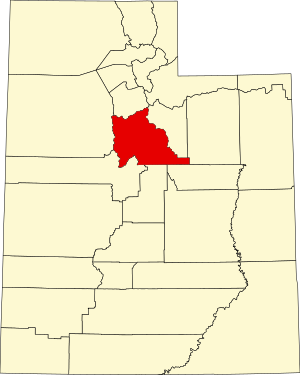
Location within the U.S. state of Utah
|
|

Utah’s location within the U.S.
|
|
| Coordinates: 40°07′N 111°40′W | |
| Country | |
| State | |
| Founded | January 31, 1850 (created) April 18, 1852 (organized) |
| Named for | Ute Tribe |
| Seat | Provo |
| Largest city | Provo |
| Area | |
| • Total | 2,144 sq mi (5,550 km2) |
| • Land | 2,003 sq mi (5,190 km2) |
| • Water | 141 sq mi (370 km2) 6.6% |
| Population
(2020)
|
|
| • Total | 659,399 |
| • Density | 310/sq mi (120/km2) |
| Time zone | UTC−7 (Mountain) |
| • Summer (DST) | UTC−6 (MDT) |
| Congressional districts | 3rd, 4th |

Contents
- 1History
- 2Geography
- 2.1Major highways
- 2.2Adjacent counties
- 2.3Protected areas
- 2.4Lakes
- 3Demographics
- 3.12000 census
- 3.2Religion
- 4Government
- 4.1Politics
- 5Social issues
- 6Infrastructure
- 7Education
- 7.1School districts
- 7.2Universities
- 8Communities
- 8.1Cities
- 8.2Towns
- 8.3Census-designated places
- 8.4Unincorporated communities
- 8.5Former communities
- 9See also
- 10References
- 11External links
History
The legislature of the State of Deseret created a county on January 31, 1850, to govern the civic affairs of Utah Valley, which by the 1850s was bustling with newly arrived settlers. The county name derived from the valley name, which derived from the Spanish name (Yuta) for the Ute Indians. The State of Deseret was dissolved soon after (April 5, 1851), but the counties it had set in place continued in existence. There is little record of any official activity conducted by the fledgling county until April 18, 1852, when a full slate of county officials was published and recordkeeping began. The first courthouse was built in central Provo in 1866–67. It was soon outgrown, and was replaced by a second courthouse (1872–73). By the 1920s this building was also cramped, and the decision was made to erect a combined city-county building, which was completed in 1926.
The county’s boundaries were adjusted in 1852, 1854, 1856, 1862, 1880, and 1884. It has retained its present boundary since 1884.
Geography
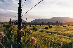
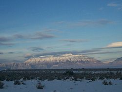
Utah County terrain ranges from stiff mountain ranges in the east (the Wasatch Range), dropping steeply to a large lake-filled valley. Most of the comparatively level ground is dedicated to agriculture or developed uses, while most of the steep terrain is covered with arid-climate forestation. The county generally slopes to the west and north, with its highest point (Mt. Nebo in the southern part of the county), at 11,928′ (3636m) ASL. The county has an area of 2,144 square miles (5,550 km2), of which 2,003 square miles (5,190 km2) is land and 141 square miles (370 km2) (6.6%) is water.
Utah Valley lies at the center of the county, lined by the mountains of the Wasatch Range on the east. Utah Lake occupies a large part of the valley. The elevation ranges from 4,487 feet (1,368 m) above sea level at the lake to 11,928 feet (3,636 m) at the peak of Mount Nebo.
Major highways
- Interstate 15
- U.S. Route 6
- U.S. Route 89
- U.S. Route 189
- Utah State Route 68
- Utah State Route 73
- Utah State Route 77
- Utah State Route 85
- Utah State Route 92
- Utah State Route 146
- Utah State Route 147
- Utah State Route 198
Adjacent counties
- Salt Lake – north
- Wasatch – northeast
- Duchesne – southeast
- Carbon – southeast
- Sanpete – south
- Juab – southwest
- Tooele – west
A partial view of Utah Valley seen here from outside of Salem
Protected areas
- Ashley National Forest (part)
- Black Hawk Campground (US Forest Service)
- Finish of the Provo River Parkway
- Manti-La Sal National Forest (part)
- Mount Timpanogos
- Powell Slough Waterfowl Management Area
- Rock Island Waterfowl Management Area
- Scofield State Park (part)
- Starvation Wildlife Management Area
- Timpanogos Cave National Monument
- Uinta-Wasatch-Cache National Forest (part)
- Utah Lake State Park
Lakes
- Utah Lake
- Provo Bay (an extension of Utah Lake)
- Scofield Reservoir (part)
Demographics
| Historical population | |||
|---|---|---|---|
| Census | Pop. | %± | |
| 1850 | 2,026 | — | |
| 1860 | 8,248 | 307.1% | |
| 1870 | 12,203 | 48.0% | |
| 1880 | 17,973 | 47.3% | |
| 1890 | 23,768 | 32.2% | |
| 1900 | 32,456 | 36.6% | |
| 1910 | 37,942 | 16.9% | |
| 1920 | 40,792 | 7.5% | |
| 1930 | 49,021 | 20.2% | |
| 1940 | 57,382 | 17.1% | |
| 1950 | 81,912 | 42.7% | |
| 1960 | 106,991 | 30.6% | |
| 1970 | 137,776 | 28.8% | |
| 1980 | 218,106 | 58.3% | |
| 1990 | 263,590 | 20.9% | |
| 2000 | 368,540 | 39.8% | |
| 2010 | 516,564 | 40.2% | |
| 2020 | 659,399 | 27.7% | |
| US Decennial Census 1790–1960 1900–1990 1990–2000 2010–2019 2020 |
|||
2000 census
As of the 2000 United States Census, there were 516,564 people, 140,602 households, and 114,350 families in the county. The population density was 258/sqmi (99.6/km2). There were 148,350 housing units, at an average density of 74.1/sqmi (28.6/km2). The county’s racial makeup was 89.4% White, 0.5% Black or African American, 0.6% American Indian or Alaska Native, 1.4% Asian, 0.8% Native Hawaiian or other Pacific Islander, 4.6% some other race, and 2.7% from two or more races. 10.8% of the population were Hispanic or Latino of any race.
There were 140,602 households, out of which 47.7% had children under the age of 18 living with them, 69.9% were headed by married couples living together, 8.0% had a female householder with no husband present, and 18.7% were non-families. 11.6% of all households were made up of individuals, and 4.4% were someone living alone who was 65 years of age or older. The average household size was 3.57, and the average family size was 3.88.
The county’s population was spread out, with 35.2% under the age of 18, 15.8% from 18 to 24, 28% from 25 to 44, 14.5% from 45 to 64, and 6.5% who were 65 years of age or older. The median age was 24.6 years. For every 100 females, there were 100.3 males. For every 100 females age 18 and over, there were 97.7 males.
At the 2000 census, the median income for a household in the county was $45,833, and the median income for a family was $50,196. Males had a median income of $37,878 versus $22,656 for females. The per capita income for the county was $15,557. About 6.80% of families and 12.00% of the population were below the poverty line, including 8.40% of those under age 18 and 4.80% of those age 65 or over.
The five most reported ancestries in Utah County are:
- English-30%
- German-10%
- Danish-7%
- Mexican-5%
- Scottish-4%
Religion
Government

View of the cities of Lehi, American Fork, Pleasant Grove, Lindon and Orem along Interstate 15 and the northeast shore of Utah Lake
The government is a three-member elected county commission elected at-large. Other elected officials include the county sheriff, the county clerk, county recorder, county assessor, county surveyor, county treasurer, and the county attorney.
In 2020, Utah County voters rejected Proposition 9, which would have changed the county’s government to a five-member elected county council with an elected county mayor.
The first sheriff of the county was John T. Willis, who was succeeded by William Madison Wall. Alexander Williams served during John Cradlebaugh’s court in 1859. He was succeeded by Eli Whipple, who resigned in 1861 and was replaced by Russell Kelly. In 2020, Sheriff Mike Smith publicly stated he would not enforce COVID-19 face mask mandates.
The Utah County Fire Department provides emergency response to all unincorporated areas within Utah County and works with all the incorporated cities within the county plus all Utah state and federal lands. The department is primarily a wildland fires response and urban interspace service with some structure fire and HAZMAT abatement capability.
Politics
Utah County has been referred to as “the most Republican county in the most Republican state in the United States”. It has only supported a Democrat for president nine times since statehood, and has not supported a Democrat for president since 1964. Indeed, 1964 is the last time a Democrat has even managed 35 percent of the county’s vote.
In the 1992 presidential election, George H. W. Bush received the most votes and Bill Clinton was third in votes received. In the 2004 presidential election, 85.99% voted for George W. Bush. In the 2008 U.S. presidential election, the county voted for John McCain by a 58.9% margin over Barack Obama, compared to McCain winning by 28.1% statewide. Eight other Utah counties voted more strongly in favor of McCain. In the 2012 election, Mitt Romney received 88.32% of the vote. In the 2016 election, it gave a slim majority of the vote to Donald Trump, and over 30% of the vote to independent candidate Evan McMullin, who outperformed Hillary Clinton in the county. This was McMullin’s largest share of the vote in any county in Utah and his second best nationwide after Madison County, Idaho. In 2020, Joe Biden received over 75,000 votes – the Democrats had never previously received more than 30,000 votes in the county. Indeed, he was the first Democrat to even win a quarter of the county’s vote since 1976.
| Position | District | Name | Affiliation | First Elected | |
|---|---|---|---|---|---|
| Senate | 7 | Mike McKell | Republican | 2020 | |
| Senate | 11 | Daniel McCay | Republican | 2018 | |
| Senate | 13 | Jake Anderegg | Republican | 2016 | |
| Senate | 14 | Mike Kennedy | Republican | 2020 | |
| Senate | 15 | Keith Grover | Republican | 2018 | |
| Senate | 16 | Curt Bramble | Republican | 2000 | |
| Senate | 24 | Derrin Owens | Republican | 2020 | |
| Senate | 27 | David Hinkins | Republican | 2008 | |
| House of Representatives | 2 | Jefferson Moss | Republican | 2016 | |
| House of Representatives | 6 | Cory Maloy | Republican | 2016 | |
| House of Representatives | 27 | Brady Brammer | Republican | 2018 | |
| House of Representatives | 48 | Keven Stratton | Republican | 2012 | |
| House of Representatives | 56 | Kay Christofferson | Republican | 2012 | |
| House of Representatives | 57 | Jon Hawkins | Republican | 2018 | |
| House of Representatives | 59 | Val Peterson | Republican | 2010 | |
| House of Representatives | 60 | Nelson Abbott | Republican | 2020 | |
| House of Representatives | 61 | Marsha Judkins | Republican | 2018 | |
| House of Representatives | 63 | Adam Robertson | Republican | 2018 | |
| House of Representatives | 64 | Norm Thurston | Republican | 2014 | |
| House of Representatives | 65 | Stephen Whyte | Republican | 2021 | |
| House of Representatives | 66 | Jeff Burton | Republican | 2020 | |
| House of Representatives | 67 | Doug Welton | Republican | 2020 | |
| House of Representatives | 68 | Merrill Nelson | Republican | 2012 | |
| Board of Education | 9 | Cindy Davis | Nonpartisan | 2018 | |
| Board of Education | 11 | Natalie Cline | Republican | 2020 | |
| Board of Education | 12 | James Moss Jr. | Republican | 2020 | |
| Board of Education | 13 | Randy Boothe | Republican | 2020 | |
| Board of Education | 14 | Mark Huntsman | Nonpartisan | 2014 | |
show
Utah County is split between two congressional districts. Most of the county is in the 3rd District, represented by Republican John Curtis. The northern portion is in the 4th District, represented by Republican Burgess Owens.
The county’s Republican bent runs right through state and local politics. All five state senators representing the county, as well as all 14 state representatives, are Republicans.
Social issues
Utah County saw high rates of opioid and other prescription drug addiction from the mid-2000s onwards, foreshadowing the national opioid crisis. The 2008 documentary Happy Valley examined the problem.
Giving USA, which reports on charitable giving in the US, named Utah County as one of the three most generous counties in philanthropic donations, alongside San Juan County, Utah and Madison County, Idaho.
In 2019, one in eight people and one in six children in the county did not have sufficient food.
Infrastructure
The I-15 CORE project added multiple lanes on Interstate 15 through most of Utah County. This expanded 24 miles (39 km) of freeway and was completed in 2012. Other construction projects by UDOT have been done on I-15 since then, including the Technology Corridor project and the Point of the Mountain project.
Education
School districts
- Alpine School District
- Provo School District
- Nebo School District.
Universities
- Brigham Young University (private)
- Utah Valley University (Utah State owned)
- Mountainland Technical College (Utah State owned)
Communities

Utah Valley, Utah County as seen from Traverse Ridge in Lehi
Mount Timpanogos in the Wasatch Range is visible from much of Utah County.
Cities
- Alpine
- American Fork
- Bluffdale (part)
- Cedar Hills
- Draper (part)
- Eagle Mountain
- Elk Ridge
- Highland
- Lehi
- Lindon
- Mapleton
- Orem
- Payson
- Pleasant Grove
- Provo (county seat)
- Salem
- Santaquin (part)
- Saratoga Springs
- Spanish Fork
- Springville
- Vineyard
- Woodland Hills
Towns
- Cedar Fort
- Fairfield
- Genola
- Goshen
Census-designated places
- Benjamin
- Elberta
- Hobble Creek
- Lake Shore
- Palmyra
- Spring Lake
- Sundance
- West Mountain
Unincorporated communities
- Birdseye
- Colton
- Soldier Summit (part)
- Vivian Park
Former communities
- Caryhurst (now within Provo city limits)
- Christmas City (area is now partially in Provo and partially in Orem)
- Dividend
- Forest City
- Homansville
- Ironton (now within Provo city limits)
- Leland (absorbed by Spanish Fork)
- Manila (former township, annexed by Pleasant Grove in 1998)
- Manning
- Mill Fork
- Mosida
- Thistle
- Tucker
- West Portal