
Réunion (/riːˈjuːnjən/; French: La Réunion, (![]() listen); previously Île Bourbon; Reunionese Creole: La Rényon) is an island in the Indian Ocean that is an overseas department and region of France. It is located approximately 950 km (590 mi) east of the island of Madagascar and 175 km (109 mi) southwest of the island of Mauritius. As of January 2022, it had a population of 868,846.
listen); previously Île Bourbon; Reunionese Creole: La Rényon) is an island in the Indian Ocean that is an overseas department and region of France. It is located approximately 950 km (590 mi) east of the island of Madagascar and 175 km (109 mi) southwest of the island of Mauritius. As of January 2022, it had a population of 868,846.
Like the other four overseas departments, Réunion also holds the status of a region of France, and is an integral part of the French Republic. Réunion is an outermost region of the European Union and is part of the eurozone. Réunion and the fellow French overseas department of Mayotte are the only eurozone regions located in the Southern Hemisphere.

Lo Mavéli or Lö Mahavéli, the unofficial flag of Réunion from 2003 used officially by various local authorities, like Saint-Denis and Saint-Philippe.
As in the rest of France, the official language of Réunion is French. In addition, a majority of the region’s population speaks Réunion Creole.
Toponymy
When France took possession of the island in the seventeenth century, it was named Bourbon, after the dynasty that then ruled France. To break with this name, which was too attached to the Ancien Régime, the National Convention decided on March 23, 1793, to rename the territory Réunion Island. (“Réunion”, in French, usually means “meeting” or “assembly” rather than “reunion”. This name was presumably chosen in homage to the meeting of the fédérés of Marseilles and the Paris National Guards that preceded the insurrection of 10 August 1792. No document establishes this and the use of the word “meeting” could have been purely symbolic.)
The island changed its name again in the 19th century: in 1806, under the First Empire, General Decaen named it Île Bonaparte (after Napoleon), and in 1810 it became Île Bourbon again. It was permanently renamed Réunion after the fall of the July monarchy by a decree of the provisional government on 7 March 1848.
In accordance with the original spelling and the classical spelling and typographical rules, “la Réunion” was written with a lower case in the article, but during the end of the 20th century, the spelling “La Réunion” with a capital letter was developed in many writings to emphasize the integration of the article in the name. This last spelling corresponds to the recommendations of the Commission nationale de toponymy and appears in the current Constitution of the French Republic in articles 72-3 and 73.
History
The island has been inhabited since the 17th century, when people from France and Madagascar settled there. Slavery was abolished on 20 December 1848 (a date celebrated yearly on the island), when the Second Republic abolished slavery in the French colonies. However, indentured workers continued to be brought to Réunion from South India, among other places. The island became an overseas department of France in 1946.
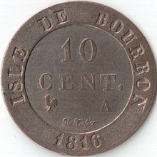
An 1816 ten-centime coin from Réunion, from when it was still called Isle de Bourbon
Not much is known of Réunion’s history prior to the arrival of the Portuguese in the early 16th century. Arab traders were familiar with it by the name Dina Morgabin, “Western Island”. The island is possibly featured on a map from 1153 AD by Al Sharif el-Edrisi. The island might also have been visited by Swahili or Austronesian (Ancient Indonesian–Malaysian) sailors on their journey to the west from the Malay Archipelago to Madagascar.
The first European discovery of the area was made around 1507 by Portuguese explorer Diogo Fernandes Pereira, but the specifics are unclear. The uninhabited island might have been first sighted by the expedition led by Dom Pedro Mascarenhas, who gave his name to the island group around Réunion, the Mascarenes. Réunion itself was dubbed Santa Apolónia after a favourite saint, which suggests that the date of the Portuguese discovery could have been 9 February, her feast day. Diogo Lopes de Sequeira is said to have landed on the islands of Réunion and Rodrigues in 1509.
By the early 1600s, nominal Portuguese rule had left Santa Apolónia virtually untouched. The island was then occupied by France and administered from Port Louis, Mauritius. Although the first French claims date from 1638, when François Cauche and Salomon Goubert visited in June 1638, the island was officially claimed by Jacques Pronis of France in 1642, when he deported a dozen French mutineers to the island from Madagascar. The convicts were returned to France several years later, and in 1649, the island was named Île Bourbon after the French royal House of Bourbon. Colonisation started in 1665, when the French East India Company sent the first settlers.

Statue of Mahé de La Bourdonnais in Saint-Denis
Revolutionary revolts
On March 19, 1793, during the French Revolution, the island’s name was changed to “Réunion Island” in homage to the meeting of the Federates of Marseille and the National Guards of Paris, during the march on the Tuileries Palace on August 10, 1792, and to erase the name of the Bourbon dynasty.
The abolition of slavery voted by the National Convention on February 4, 1794, was rejected by Réunion, as well as by Île de France (Mauritius). A delegation accompanied by military forces, charged with imposing the liberation of slaves, arrived on the island of Bourbon on June 18, 1796, only to be immediately expelled without mercy. There followed a period of unrest and challenges to the power of the metropolis, which no longer had any authority over the two islands. The First Consul of the Republic, Napoleon Bonaparte, maintained slavery there, which was never abolished in practice, with the law of May 20, 1802. On September 26, 1806, the island took the name of Bonaparte and found itself in the front line of the Franco-British conflict for the control of the Indian Ocean.
During the Napoleonic Wars, the island was invaded by British forces and its governor, General Sainte-Suzanne, was forced to capitulate on July 9, 1810. The island then came under British rule and was returned to the French under the Treaty of Paris of 1814.
Following climatic catastrophes of 1806-1807 (cyclones, floods), coffee cultivation declined rapidly and was replaced by sugar cane, whose demand in France increased, due to France’s recent loss of Saint-Domingue, and soon of the Île-de-France (Mauritius). Because of its growth cycle, sugarcane is not affected by cyclones. In 1841, Edmond Albius’ discovery of hand-pollination of vanilla flowers enabled the island to soon become the world’s leading vanilla producer. The cultivation of geranium, whose essence is widely used in perfumery, also took off.
From 1838 to 1841, Rear Admiral Anne Chrétien Louis de Hell was governor of the island. A profound change of society and mentality linked to the events of the last ten years led the governor to present three emancipation projects to the Colonial Council.
On December 20, 1848, Sarda Garriga finally proclaimed the abolition of slavery (December 20 was a holiday in Réunion). Louis Henri Hubert Delisle became its first Creole governor on August 8, 1852, and remained in this position until January 8, 1858. Europe increasingly turned to sugar beet to meet its sugar needs. Despite the development policy of the local authorities and the recourse to compromise, the economic crisis became evident from the 1870s onwards. Subsequently, the opening of the Suez Canal caused a shift in commercial traffic away from the island. However, this economic depression did not prevent the modernization of the island, with the development of the road network, the creation of the railroad and the construction of the artificial harbor of the Pointe des Galets. These major construction projects offered a welcome alternative for agricultural workers.
Modern history
From the 17th to the 19th centuries, French colonisation, supplemented by importing Africans, Chinese and Indians as workers, contributed to ethnic diversity in the population. From 1690, most of the non-Europeans on the island were enslaved. The colony abolished slavery on 20 December 1848. Afterwards, many of the foreign workers came as indentured workers. The opening of the Suez Canal in 1869 reduced the importance of the island as a stopover on the East Indies trade route.

Hindu festival, 19th century
During the Second World War, Réunion was under the authority of the Vichy regime until 30 November 1942, when Free French forces took over the island with the destroyer Léopard.
Réunion became a département d’outre-mer (overseas département) of France on 19 March 1946. INSEE assigned to Réunion the department code 974, and the region code 04 when regional councils were created in 1982 in France, including in existing overseas departments which also became overseas regions.
Over about two decades in the late 20th century (1963–1982), 1,630 children from Réunion were relocated to rural areas of metropolitan France, particularly to Creuse, ostensibly for education and work opportunities. That program was led by influential Gaullist politician Michel Debré, who was an MP for Réunion at the time. Many of these children were abused or disadvantaged by the families with whom they were placed. Known as the Children of Creuse, they and their fate came to light in 2002 when one of them, Jean-Jacques Martial, filed suit against the French state for kidnapping and deportation of a minor. Other similar lawsuits were filed over the following years, but all were dismissed by French courts and finally by the European Court of Human Rights in 2011.
In 2005 and 2006, Réunion was hit by a crippling epidemic of chikungunya, a disease spread by mosquitoes. According to the BBC News, 255,000 people on Réunion had contracted the disease as of 26 April 2006. The neighbouring islands of Mauritius and Madagascar also suffered epidemics of this disease during the same year. A few cases also appeared in mainland France, carried by people travelling by airline. The French government of Dominique de Villepin sent an emergency aid package worth €36 million and deployed about 500 troops in an effort to eradicate mosquitoes on the island.
Politics
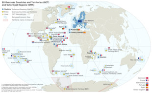
Map of the European Union (pre Brexit on January 31st 2020) in the world, with overseas countries and territories and outermost regions
Réunion sends seven deputies to the French National Assembly and three senators to the Senate.
Status
Réunion is an Overseas department and region of France (known in French as a Département et Région d’Outre-Mer, DROM) governed by Article 73 of the Constitution of France, under which the laws and regulations are applicable as of right, as in metropolitan France.
Thus, Réunion has a regional council and a departmental council. These territorial entities have the same general powers as the departments and regions of metropolitan France, albeit with some adaptations. Article 73 of the Constitution provides for the possibility of replacing the region and the department by a single territorial entity, but, unlike French Guiana or Martinique, there are currently no plans to do so. Unlike the other DROMs, the Constitution explicitly excludes Réunion from the possibility of receiving authorization from Parliament to set certain rules itself, either by law or by the national executive. The State is represented in Réunion by a prefect. The territory is divided into four districts (Saint-Benoît, Saint-Denis, Saint-Paul and Saint-Pierre). Réunion has 24 municipalities organized into 5 agglomeration communities. From the point of view of the European Union, Réunion is considered an “outermost region.”
Geopolitics
The positioning of Réunion Island has given it a more or less important strategic role depending on the period.

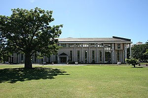
Palais de la Source, seat of the Departmental Council of Réunion
Already at the time of the India Route or Route des Indes, Réunion was a French possession located between Cape Town and the Indian trading posts, although far from the Mozambique Channel. Île de Bourbon (its name under the Ancien Régime) was not, however, the preferred position for trade and military. Governor Labourdonnais claimed that Île de France (Mauritius) was a land of opportunity, thanks to its topography and the presence of two natural harbours. He intended Île de Bourbon to be a depot or an emergency base for Île de France.
The opening of the Suez Canal diverted much of the maritime traffic from the southern Indian Ocean and reduced the strategic importance of the island. This decline is confirmed by the importance given to Madagascar, which was later colonized.
Today, the island, the seat of a defense and security zone, is the headquarters of the French Armed Forces of the Southern Indian Ocean Zone (FAZSOI), which brings together French Army units stationed in La Réunion and Mayotte. Réunion is also a base for the so-called Frenchelon signal intelligence system, whose infrastructure includes a mobile listening and automatic search unit. Saint-Pierre is also the headquarters of the mostly uninhabited French Southern and Antarctic Lands (Terres australes et antarctiques françaises, TAAF). Because of France’s possession of Réunion, France is a member of the Indian Ocean Commission, which also includes the Comoros, Madagascar, Mauritius and the Seychelles.
Administrative divisions
Administratively, Réunion is divided into 24 communes (municipalities) grouped into four arrondissements. It is also subdivided into 25 cantons, meaningful only for electoral purposes at the departmental or regional level. It is a French overseas department, hence a French overseas region. The low number of communes, compared with French metropolitan departments of similar size and population, is unique: most of its communes encompass several localities, sometimes separated by significant distances.
Municipalities (communes)
| Name | Area (km2) | Population (2019) | Coat of Arms | Arrondissement | Map |
|---|---|---|---|---|---|
| Les Avirons | 26.27 | 11,440 | Saint-Pierre | ||
| Bras-Panon | 88.55 | 13,057 | Saint-Benoît | ||
| Cilaos | 84.4 | 5,538 | Saint-Pierre | ||
| Entre-Deux | 66.83 | 6,927 | Saint-Pierre | ||
| L’Étang-Salé | 38.65 | 14,059 | Saint-Pierre | ||
| Petite-Île | 33.93 | 12,395 | Saint-Pierre | ||
| La Plaine-des-Palmistes | 83.19 | 6,626 | Saint-Benoît | ||
| Le Port | 16.62 | 32,977 | Saint-Paul | ||
| La Possession | 118.35 | 32,985 | Saint-Paul | ||
| Saint-André | 53.07 | 56,902 | Saint-Benoît | ||
| Saint-Benoît | 229.61 | 37,036 | Saint-Benoît | ||
| Saint-Denis | 142.79 | 153,810 | Saint-Denis | ||
| Saint-Joseph | 178.5 | 37,918 | Saint-Pierre | ||
| Saint-Leu | 118.37 | 34,586 | Saint-Paul | ||
| Saint-Louis | 98.9 | 53,120 | Saint-Pierre | ||
| Saint-Paul | 241.28 | 103,208 | Saint-Paul | ||
| Saint-Philippe | 153.94 | 5,198 | Saint-Pierre | ||
| Saint-Pierre | 95.99 | 84,982 | Saint-Pierre | ||
| Sainte-Marie | 87.21 | 34,061 | Saint-Denis | ||
| Sainte-Rose | 177.6 | 6,345 | Saint-Benoît | ||
| Sainte-Suzanne | 58.84 | 24,065 | Saint-Denis | ||
| Salazie | 103.82 | 7,136 | Saint-Benoît | ||
| Le Tampon | 165.43 | 79,824 | Saint-Pierre | ||
| Les Trois-Bassins | 42.58 | 7,015 | Saint-Paul |
The High Court (Tribunal de grande instance) in Saint-Denis, Réunion.
The communes voluntarily grouped themselves into five groups for cooperating in some domains, apart from the four arrondissements to which they belong for purposes of national laws and executive regulation. After some changes in their composition, name and status, all of them operate with the status of agglomeration communities, and apply their own local taxation (in addition to national, regional, departmental, and municipal taxes) and have an autonomous budget decided by the assembly representing all member communes. This budget is also partly funded by the state, the region, the department, and the European Union for some development and investment programs. Every commune in Réunion is now a member of such an intercommunality, with its own taxation, to which member communes have delegated their authority in various areas.
Foreign relations
Although diplomacy, military, and French government matters are handled by Paris, Réunion is a member of La Francophonie, the Indian Ocean Commission, the International Trade Union Confederation, the Universal Postal Union, the Port Management Association of Eastern and Southern Africa, and the World Federation of Trade Unions in its own right.
Defence
The French Armed Forces are responsible for the defence of the department. These forces also contribute to the defence of other French territories in the region, including Mayotte and the French Southern and Antarctic Lands. A total of some 2,000 French troops are deployed in the region – mostly in Reunion centred on the 2nd Marine Infantry Parachute Regiment – along with modest air transport and surveillance assets. The French naval presence includes: two Floréal-class frigates, Floréal and Nivôse, the icebreaker L’Astrolabe, the patrol and support ship Champlain and the coast guard vessel Le Malin.
Geography
3 071 m
2 632 m
Suzanne
Marie
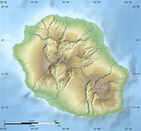
The island is 63 km (39 mi) long; 45 km (28 mi) wide; and covers 2,512 km2 (970 sq mi). It is above a hotspot in the Earth’s crust. The Piton de la Fournaise, a shield volcano on the eastern end of Réunion Island, rises more than 2,631 m (8,632 ft) above sea level and is sometimes called a sister to Hawaiian volcanoes because of the similarity of climate and volcanic nature. It has erupted more than 100 times since 1640, and is under constant monitoring, most recently erupting on 2 April 2020. During another eruption in April 2007, the lava flow was estimated at 3,000,000 m3 (3,900,000 cu yd) per day. The hotspot that fuels Piton de la Fournaise also created the islands of Mauritius and Rodrigues.
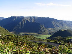
The Piton des Neiges volcano, the highest point on the island at 3,070 m (10,070 ft) above sea level, is northwest of the Piton de la Fournaise. Collapsed calderas and canyons are south west of the mountain. While the Piton de la Fournaise is one of Earth’s most active volcanoes, the Piton des Neiges is dormant. Its name is French for “peak of snows”, but snowfall on the summit of the mountain is rare. The slopes of both volcanoes are heavily forested. Cultivated land and cities like the capital city of Saint-Denis are concentrated on the surrounding coastal lowlands. Offshore, part of the west coast is characterised by a coral reef system. Réunion also has three calderas: the Cirque de Salazie, the Cirque de Cilaos and the Cirque de Mafate. The last is accessible only on foot or by helicopter.
-
Plaine-des-Palmistes
-

Cirque de Mafate is a caldera formed from the collapse of the large shield volcano the Piton des Neiges.
-
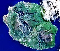
Réunion from space (NASA image): The three cirques, forming a kind of three-leafed clover shape, are visible in the central north west of the image. Piton de la Fournaise is in the south east.
-
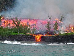
Lava flow emitted in 2005 by the Piton de la Fournaise
-
Plage de l’Ermitage beach
Geology and relief
Reunion Island is a volcanic island born some three million years ago with the emergence of the Piton des Neiges volcano which is today, with an altitude of 3,070.50 m, the highest peak in the Mascarene Islands and the Indian Ocean. The eastern part of the island is constituted by the Piton de la Fournaise, a much more recent volcano (500,000 years old) which is considered one of the most active on the planet. The emerged part of the island represents only a small percentage (about 3%) of the underwater mountain that forms it.
In addition to volcanism, the relief of the island is very uneven due to active erosion. The center shelters three vast cirques dug by erosion (Salazie, Mafate and Cilaos) and the slopes of the island are furrowed by numerous rivers digging gullies, estimated at least 600, generally deep and whose torrents cut the sides of the mountains up to several hundreds of meters deep.
The ancient massif of the Piton des Neiges is separated from the massif of La Fournaise by a gap formed by the plaine des Palmistes and the plaine des Cafres, a passageway between the East and the South of the island. Apart from the plains, the coastal areas are generally the flattest regions, especially in the north and west of the island. The coastline of the wild south is however steeper.
Between the coastal fringe and the Hauts, there is a steep transitional zone whose gradient varies considerably before arriving at the ridge lines setting the cirques or the Enclos, the caldera of the Piton de la Fournaise.
Climate

Köppen climate classification map of Réunion
The island of Reunion is characterized by a humid tropical climate, tempered by the oceanic influence of the trade winds blowing from east to west. The climate of Reunion is characterized by its great variability, mainly due to the imposing relief of the island, which is at the origin of numerous microclimates.
As a result, there are strong disparities in rainfall between the windward coast in the east and the leeward coast in the west, and in temperature between the warmer coastal areas and the relatively cooler highland areas.
In Réunion there are two distinct seasons, defined by the rainfall regime:
- a rainy season from January to March, during which most of the year’s rain falls;
- a dry season from May to November. However, in the eastern part and in the foothills of the volcano, rainfall can be significant even in the dry season;
April and December are transition months, sometimes very rainy but also very dry.
Pointe des Trois Bassins, located on the coast of the commune of Trois-Bassins (West), is the driest season, with a normal annual precipitation of 447.7 mm (17.63 in), while Le Baril, in Saint-Philippe (Southeast), is the wettest coastal season, with a normal annual precipitation of 4,256.2 mm (167.57 in).
However, the wettest station is in the highlands of Sainte-Rose, with an average annual rainfall of almost 11,000 mm (430 in), making it one of the wettest places in the world.
Temperatures in Reunion are characterized by their great mildness throughout the year. In fact, the thermal amplitude from one season to another is relatively small (rarely exceeding 10°C or 18°F), although it is perceptible:
- In the warm season (November to April): average minimums usually range between 21 and 24 °C (70 and 75 °F), and average maximums between 28 and 31 °C (82 and 88 °F), on the coast. At 1,000 m (3,300 ft), average minimums fluctuate between 10 and 14 °C (50 and 57 °F) and average maximums between 21 and 24 °C (70 and 75 °F);
- In the cold season (May to October): temperatures at sea level vary from 17 to 20 °C (63 to 68 °F) for average minimums and from 26 to 28 °C (79 to 82 °F) for average maximums. At 1,000 m (3,300 ft), average minimums range from 8 to 10 °C (46 to 50 °F) and average maximums from 17 to 21 °C (63 to 70 °F).
In mountain towns, such as Cilaos or La Plaine-des-Palmistes, average temperatures range between 12 and 22 °C (54 and 72 °F). The highest parts of the habitat and the natural areas at altitude may suffer some winter frosts. Snow was even observed on the Piton des Neiges and Piton de la Fournaise in 2003 and 2006.
The warmest day on record set on January 30, 2022. In the cold pole of the Reunion Island (all time low -5C) Gite de Bellecombe (2245m asl) with a max. temperature of 25.4C on 30 January. It beats the previous record of 25.1C set in 2021 and 2021.
While a growing number of islands (including “non-sovereign” islands) in the world are concerned about the effects of climate change, the island of Reunion was chosen (along with Gran Canaria in Spain) as an example for a case study of an affected ultra-European peripheral territory, for a study on the adequacy of urban and regional planning tools to the needs and characteristics of these islands (including land use and population density and the regulatory framework).
This work confirmed that urban and peri-urban land use pressures are high, and that adaptation strategies are incompletely integrated into land use planning. According to the Institute of Island Studies, there is a dysfunction: “island planning tools often do not take climate change adaptation into account and there is too much top-down management in the decision-making process”. Réunion holds the world records for the most rainfall in 12-, 24-, 72- and 96-hour periods, including nearly 6 ft (1.8 meters) in 24 hours.
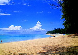
Beaches
Réunion hosts many tropical and unique beaches. They are often equipped with barbecues, amenities, and parking spaces. Hermitage Beach is the most extensive and best-preserved lagoon in Réunion Island and a popular snorkelling location. It is a white sand beach lined with casuarina trees under which the locals often organise picnics. La Plage des Brisants is a well-known surfing spot, with many athletic and leisurely activities taking place. Each November, a film festival is also organised in La Plage des Brisant’s. Movies are projected on a large screen in front of a crowd. Beaches at Boucan Canot are surrounded by a stretch of restaurants that particularly cater to tourists. L’Étang-Salé on the west coast is a particularly unique beach as it is covered in black sand consisting of tiny fragments of basalt. This occurs when lava contacts water, it cools rapidly and shatters into the sand and fragmented debris of various size. Much of the debris is small enough to be considered sand. Grand Anse is a tropical white-sand beach lined with coconut trees in the south of Réunion, with a rock pool built for swimmers, a pétanque playground, and a picnic area. Le Vieux Port in Saint Philippe is a green-sand beach consisting of tiny olivine crystals, formed by the 2007 lava flow, making it one of the youngest beaches on Earth.
-

Sunset at Grand Anse beach Reunion Island
-
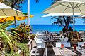
Restaurants along Boucan Canot beach
-
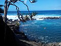
Manapany beach rock pool
-

L’Étang-Salé Beach – a black sand beach from volcanic basalt
-

L’Ermitage les Bains lagoon in front of Saint Paul, and its pass through the coral reef
Environment
Flora
The tropical and insular flora of Reunion Island is characterized by its diversity, a very high rate of endemism and a very specific structure. The flora of Reunion presents a great diversity of natural environments and species (up to 40 tree species/ha, compared to a temperate forest which has an average of 5/ha). This diversity is even more remarkable, but fragile, as it differs according to the environment (coastal, low, medium and high mountain).
Reunion has a very high rate of endemic species, with more than 850 native plants (of natural origin and present before the arrival of man), of which 232 are endemic to the island of Reunion (only present on the island), as well as numerous species endemic to the Mascarene archipelago. Finally, the flora of Reunion is distinguished from that of equatorial tropical forests by the low height and density of the canopy, probably due to adaptation to cyclones, and by a very specific vegetation, in particular a strong presence of epiphytic plants (growing on other plants), such as orchids, bromeliads and cacti, but also ferns, lichens and mosses.
Wildlife
Like its prodigious floral diversity, Réunion is home to a variety of birds such as the white-tailed tropicbird (French: paille en queue). Many of these birds species are endemic to the island, such as the Réunion harrier and Réunion cuckooshrike. Its largest land animal is the panther chameleon, Furcifer pardalis. Much of the west coast is ringed by coral reef which harbours, among other animals, sea urchins, conger eels, and parrot fish. Sea turtles and dolphins also inhabit the coastal waters. Humpback whales migrate north to the island from the Antarctic waters annually during the Southern Hemisphere winter (June–September) to breed and feed, and can be routinely observed from the shores of Réunion during this season. At least 19 species formerly endemic to Réunion have become extinct following human colonisation. For example, the Réunion giant tortoise became extinct after being slaughtered in vast numbers by sailors and settlers of the island.
-

A panther chameleon
-
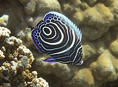
A juvenile Emperor angelfish
-
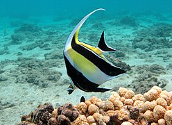
A Moorish idol
-
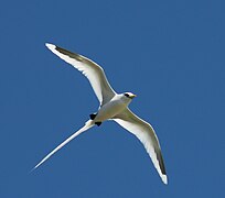
A white-tailed Tropicbird
-

A Hawksbill sea turtle
-
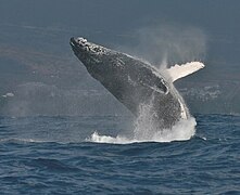
A Humpback whale off St-Gilles
Marine biodiversity
Despite the small area of coral reefs, the marine biodiversity of Reunion Island is comparable to that of other islands in the area, which has earned the Mascarene archipelago its inclusion among the top ten global biodiversity “hotspots”. Reunion’s coral reefs, both flat and barrier, are dominated mainly by fast-growing branching coral species of the genus Acropora (family Acroporidae), which provide shelter and food for many tropical species.
Recent scientific research in Reunion Island indicates that there are more than 190 species of corals, more than 1,300 species of mollusks, more than 500 species of crustaceans, more than 130 species of echinoderms and more than 1,000 species of fish.
Reunion’s deeper waters are home to dolphins, killer whales, humpback whales, blue sharks and a variety of shark species, including whale sharks, coral sharks, bull sharks, tiger sharks, blacktip sharks and great white sharks. Several species of sea turtles live and breed here.
Between 2010 and 2017, 23 shark attacks occurred in the waters of Réunion, of which nine were fatal. In July 2013, the Prefect of Réunion Michel Lalande announced a ban on swimming, surfing, and bodyboarding off more than half of the coast. Lalande also said 45 bull sharks and 45 tiger sharks would be culled, in addition to the 20 already killed as part of scientific research into the illness ciguatera.
Migrations of humpback whales contributed to a boom of whale watching industries on Réunion, and watching rules have been governed by the OMAR (Observatoire Marin de la Réunion) and Globice (Groupe local d’observation et d’identification des cétacés).
Coral reef

L’Ermitage Lagoon
Because the island is relatively young (3 million years old), the coral formations (8,000 years old) are not well developed and occupy a small area compared to older islands, mostly in the form of fringing reefs.