
Anjaw District
(Pron:/ˈændʒɔ:/) is an administrative district in the state of Arunachal Pradesh in north-east India. It was created district in 2004, by splitting off from the Lohit district under the Arunachal Pradesh Re-organization of Districts Amendment Act. The district borders China on the north. Hawai, at an altitude of 1296 m above sea level, is the district headquarters, located on the banks of the Lohit River, a tributary of the Brahmaputra River. It is the easternmost district in India. The furthest villages towards the border with Chin are Dong, Walong, Kibithu and Kaho.

Landscape of Anjaw
Anjaw is the second least populous district in India (out of 640).
History
During the 1962 war, parts of Anjaw were briefly occupied by China. Being a disputed border region, Indian military has always been present in the Anjaw district. During the 2020 China–India skirmishes additional troops were deployed to the region.
Geography
Rivers
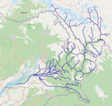
Lohit River Basin
The main rivers are the following:
- Lohit River (called Telu by local Mishmis)
- Lam River
- Tidding River
- Delei River
- Krowti River
- Dichu River
- Lati River
- Klung River
- Dav River
- Telua River
- Ampani River
- Sarti River
Transport
The 2,000-kilometre-long (1,200 mi) proposed Mago-Thingbu to Vijaynagar Arunachal Pradesh Frontier Highway along the McMahon Line, (will intersect with the proposed East-West Industrial Corridor Highway) and will pass through this district, alignment map of which can be seen here and here.
Economy
Agriculture
The main crops are maize, millet, rice, beans, cardamom, orange, pears, plum, and apple.
Divisions
There is one Arunachal Pradesh Legislative Assembly constituency located in this district: Hayuliang. It is part of the Arunachal East Lok Sabha constituency.
The district has seven subdistricts called “circles”:
- Hayuliang
- Goiliang
- Chaglagam
- Manchal
- Hawai
- Walong
- Kibithoo

Anjaw district
Demographics
According to the 2011 census Anjaw district has a population of 21,089, roughly equal to the nation of Palau. This gives it a ranking of 639th in India (out of a total of 640). The district has a population density of 3 inhabitants per square kilometre (7.8/sq mi). Its population growth rate over the decade 2001–2011 was 13.77%. Anjaw has a sex ratio of 805 females for every 1000 males, and a literacy rate of 59.4%.
Tribes
The Mishmi, and the Zakhring (formerly called Meyor) are the main tribes in the district.
Tribal population is 16,451 (77.72%) as per the 2011 census, with the largest tribes being Idu/Taraon Mishmi (9,991), Kaman/Miju Mishmi (5,021), Degaru Mishmi (472), and Meyor (472).
Languages
According to the 2011 Census: Mishmi (72.61%), Hindi (7.06%), Gorkhali (5.29%), Tibetan (2.29%), Bengali (2.13%), Punjabi (1.55%), Dogri (1.17%), Adi (0.90%), and Mizo (0.88%).
Religion
As per the 2011 Census: Hindu – 61.83%, Native faith – 28.99%, Muslim – 3.09%, Buddhist – 3.04%.
Among the tribals, major religions are Hinduism (57.67%), Native faith (37.07%), Buddhism (3.15%), and Islam (0.99%).
Among the non-tribals, the composition is Hinduism (76.36%), Islam (10.43%), Sikh (5.66%), Christian (3.54%), and Buddhism (2.65%).
Flora and fauna
The district is rich in wildlife. Rare mammals such as Mishmi takin, Red goral, Gongshan muntjac, Leaf muntjac occurs while among birds there is the rare Sclater’s Monal. A pine, Pinus merkusii is found only in this district in the entire northeastern India. A flying squirrel, new to science has also its range in this district. It has been named as Mishmi Hills Giant Flying Squirrel, Petaurista mishmiensis.
Banking Facilities
The list of banks functioning in Anjaw:
- State Bank of India, Hawai
- State Bank of India, Hayuliang Branch