
Hyderabad district is a district in the state of Telangana in India that contains a part of the metropolitan area of Hyderabad. It is headed by a district collector who is drawn from the IAS cadre and is appointed by the state government. It is the smallest of all the districts in the state, but has the highest human density. Old MCH area, which is central region of Hyderabad city comes under this district.The district share boundaries with Rangareddy and Medhchal districts.
History

Hyderabad District before and after 1956 with Taluks
Hyderabad district was formed in 1948 after Operation Polo by merging Atraf-a-Balda District and Baghat District. Baghat was previously a Taluk in Atraf-e-Balda District, and was made a separate district in 1931–34 under the subedar of Medak division. After formation of Andhra Pradesh by merging Telugu speaking of Hyderabad state in 1956 Hyderabad district boundary was altered Tandur Taluka which is Telugu speaking region of Gulbarga district was merged in Hyderabad district and Parigi Taluka of Mahabubnagar district and Vikarabad Taluka of Medak District also merged in Hyderabad district. In 1978 Hyderabad district was later split into Hyderabad Urban District and Hyderabad Rural District.Hyderabad Urban District was made by 4 Talukas are Charminar, Golkonda, Mushirabad and Secunderabad Talukas. Hyderabad rural district was later renamed as Ranga Reddy District. Hyderabad Urban district subdivided in 16 Mandals in 1985 and consist of 2 Revenue division
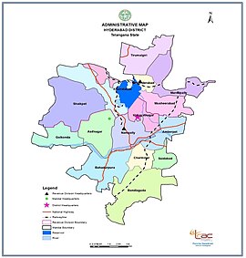
Administrative divisions
Hyderabad District includes the area of the core area Greater Hyderabad Municipal Corporation, Secunderabad Cantonment, and Osmania University. There are 16 administrative areas called mandals (or tehsils) in Hyderabad. They are:
| # | Hyderabad revenue division | # | Secunderabad revenue division |
|---|---|---|---|
| 1 | Amberpet | 11 | Ameerpet |
| 2 | Asifnagar | 12 | Khairtabad |
| 3 | Bahadurpura | 13 | Marredpally |
| 4 | Bandlaguda | 14 | Musheerabad |
| 5 | Charminar | 15 | Trimulgherry |
| 6 | Golconda | 16 | Secunderabad |
| 7 | Himayathnagar | 17 | Secunderabad Cantonment |
| 8 | Nampally | ||
| 9 | Shaikpet | ||
| 10 | Saidabad |
Hyderabad district comprises 15 Assembly constituencies in the core of the Greater Hyderabad Municipal Corporation.
Geography
Hyderabad District IND
Hyderabad district occupies an area of approximately 217 square kilometres (84 sq mi).
Demographics
In the 2011 census Hyderabad district’s population was 3,943,323, with a religious make-up of: Hindus (51.45%), Muslims (43.89%), Christians (2.22%), Jains (0.5%), Sikhs (0.29%) and Buddhists (0.03%); 1.58% did not state any religion. It is roughly equal to the nation of Liberia or the US state of Oregon.
This gives it a ranking of 57th in India (out of a total of 640). The district has a population density of 18,480 inhabitants per square kilometre (47,900/sq mi) . Its population growth rate over the decade 2001–2011 was 4.71%. Hyderabad has a sex ratio of 943 females for every 1000 males, and a literacy rate of 80.96%.
| Year | Pop. | ±% p.a. |
|---|---|---|
| 1901 | 499,082 | — |
| 1911 | 627,720 | +2.32% |
| 1921 | 556,913 | −1.19% |
| 1931 | 588,217 | +0.55% |
| 1941 | 810,790 | +3.26% |
| 1951 | 1,083,634 | +2.94% |
| 1961 | 1,191,668 | +0.95% |
| 1971 | 1,682,284 | +3.51% |
| 1981 | 2,251,009 | +2.96% |
| 1991 | 3,145,939 | +3.40% |
| 2001 | 3,829,753 | +1.99% |
| 2011 | 3,943,323 | +0.29% |
| source: | ||
| Year | Percent |
|---|---|
| 1981 | 35.91 |
| 1991 | 39.35 |
| 2001 | 41.17 |
| 2011 | 43.45 |
Climate
| hide | |||||||||||||
|---|---|---|---|---|---|---|---|---|---|---|---|---|---|
| Month | Jan | Feb | Mar | Apr | May | Jun | Jul | Aug | Sep | Oct | Nov | Dec | Year |
| Record high °C (°F) | 35.9 (96.6) |
39.1 (102.4) |
42.2 (108.0) |
43.3 (109.9) |
44.5 (112.1) |
45.5 (113.9) |
37.4 (99.3) |
36.2 (97.2) |
36.1 (97.0) |
36.7 (98.1) |
34.0 (93.2) |
34.2 (93.6) |
45.5 (113.9) |
| Average high °C (°F) | 29.3 (84.7) |
32.4 (90.3) |
35.9 (96.6) |
38.1 (100.6) |
39.4 (102.9) |
34.9 (94.8) |
31.3 (88.3) |
30.1 (86.2) |
31.1 (88.0) |
31.0 (87.8) |
29.6 (85.3) |
28.7 (83.7) |
32.7 (90.9) |
| Daily mean °C (°F) | 22.7 (72.9) |
25.3 (77.5) |
28.6 (83.5) |
31.3 (88.3) |
33.0 (91.4) |
29.7 (85.5) |
27.0 (80.6) |
26.2 (79.2) |
26.7 (80.1) |
25.8 (78.4) |
23.7 (74.7) |
21.9 (71.4) |
26.8 (80.2) |
| Average low °C (°F) | 15.9 (60.6) |
18.3 (64.9) |
21.5 (70.7) |
24.4 (75.9) |
26.3 (79.3) |
24.2 (75.6) |
22.8 (73.0) |
22.2 (72.0) |
22.3 (72.1) |
20.6 (69.1) |
17.4 (63.3) |
15.1 (59.2) |
20.9 (69.6) |
| Record low °C (°F) | 6.1 (43.0) |
8.9 (48.0) |
13.2 (55.8) |
16.0 (60.8) |
16.7 (62.1) |
17.8 (64.0) |
18.6 (65.5) |
18.7 (65.7) |
17.8 (64.0) |
11.7 (53.1) |
7.4 (45.3) |
7.1 (44.8) |
6.1 (43.0) |
| Average rainfall mm (inches) | 9.3 (0.37) |
9.2 (0.36) |
17.8 (0.70) |
21.7 (0.85) |
31.7 (1.25) |
111.2 (4.38) |
179.2 (7.06) |
207.0 (8.15) |
132.9 (5.23) |
103.6 (4.08) |
26.1 (1.03) |
4.9 (0.19) |
854.6 (33.65) |
| Average rainy days | 0.6 | 0.5 | 1.1 | 1.8 | 2.4 | 6.9 | 10.0 | 11.5 | 7.6 | 5.5 | 1.6 | 0.4 | 49.9 |
| Average relative humidity (%) (at 17:30 IST) | 40 | 32 | 28 | 28 | 30 | 51 | 64 | 69 | 65 | 56 | 48 | 43 | 46 |
| Mean monthly sunshine hours | 272.8 | 265.6 | 272.8 | 276.0 | 279.0 | 180.0 | 136.4 | 133.3 | 162.0 | 226.3 | 243.0 | 251.1 | 2,698.3 |
| Mean daily sunshine hours | 8.8 | 9.4 | 8.8 | 9.2 | 9.0 | 6.0 | 4.4 | 4.3 | 5.4 | 7.3 | 8.1 | 8.1 | 7.4 |
| Source 1: India Meteorological Department (sun 1971–2000) | |||||||||||||
| Source 2: Tokyo Climate Center (mean temperatures 1981–2010) |
|||||||||||||