
The Indian union territory of Jammu and Kashmir consists of two divisions: Jammu Division and Kashmir Division, and is further divided into 20 districts:
History
Princely state of Kashmir
Prior to 1947, Kashmir was a princely state under the paramountcy of the British Indian Empire. The central part of the princely state was administratively divided into the provinces Jammu and Kashmir. In addition there were frontier districts and semi-autonomous jagirs (principalities). They were subdivided as follows:
- Kashmir province: Districts of Srinagar, Anantnag, Baramulla and Muzaffarabad. (Muzzafarabad later became part of Azad Kashmir.)
- Internal jagirs: Poonch (half of it later became part of Azad Kashmir), Chenani and Bhaderwah
- Jammu province: Districts of Jammu, Udhampur and Mirpur (later became part of Azad Kashmir)
- Frontier districts:
-
- Ladakh district with three sub-districts: Leh, Kargil and Skardu (Skardu later became part of Gilgit-Baltistan.)
- Gilgit district with two sub-districts: Gilgit and Astore. (Both later became part of Gilgit-Baltistan.)
- Frontier ilaqas comprising Punial, Ishkoman, Yasin, Kuh Ghizar, Hunza, Nagar and Chilas. (All of these regions later became part of Gilgit-Baltistan.)
The Gilgit district and the frontier ilaqas were administered by the British administration as the Gilgit Agency, which were returned to the princely state prior to the Partition of India.
Partition
Following the independence of India and Pakistan, in October 1947, there was a Poonch rebellion as Muslims were disarmed by the orders of raja of Kashmir.So they rebelled out in the western districts of the princely state coupled with a tribal invasion, both of which were supported by the newly independent Dominion of Pakistan. The princely ruler acceded to India in return for armed assistance. India and Pakistan fought the First Kashmir War that lasted through 1948, at the end of which large parts of the three western districts of Mirpur, Poonch and Muzaffarabad, the whole of the Gilgit Agency and the Skardu sub-district of Ladakh came under Pakistani control. The remainder of the princely state has been organised as a state of India under the name Jammu Kashmir.
Inside India
A. Gilgit
B. Ladakh (northern and eastern portions)
C. Gilgit Wazarat
D. Chilas
E. Tribal territory
F. Muzaffarabad
G. Punch (western portion)
H. Mirpur
The territory under the Indian control include:
- Jammu Division: districts of Jammu, Kathua, Udhampur, Reasi; the jagirs of Chenani and Bhaderwah; 11 per cent of the Mirpur district and 40 per cent of the Poonch jagir.
- Kashmir Division: Kashmir South (Anantnag) and Kashmir North (Baramulla); 13 per cent of the Muzaffarabad district.
- Ladakh Division: Kargil and Leh districts. (Became the union territory of Ladakh on 31 October 2019.)
The districts were reorganised by 1968, breaking up some of the larger districts. In 2006, eight new districts were created: Kishtwar, Ramban, Reasi, Samba, Bandipora, Ganderbal, Kulgam and Shopian.
In August 2019, the Jammu and Kashmir Reorganisation Act was passed by both houses of the Indian Parliament. The provisions contained in the bill reorganised the state of Jammu and Kashmir into two union territories; Jammu and Kashmir (union territory) and Ladakh with effect from 31 October 2019.
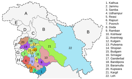
Districts
Jammu Division
Jammu Division
| Name | Headquarters | Before 2007[8] | After 2007 | Population 2001 Census |
Population 2011 Census |
||
|---|---|---|---|---|---|---|---|
| Area (km2) |
Area (km2) |
Area (sq miles) |
|||||
| Kathua district | Kathua | 2,651 | 2,502 | 966 | 550,084 | 615,711 | |
| Jammu district | Jammu | 3,097 | 2,342 | 1,343,756 | 1,526,406 | ||
| Samba district | Samba | new district | 904 | 245,016 | 318,611 | ||
| Udhampur district | Udhampur | 4,550 | 2,367 | 475,068 | 555,357 | ||
| Reasi district | Reasi | new district | 1,719 | 268,441 | 314,714 | ||
| Rajouri district | Rajouri | 2,630 | 2,630 | 483,284 | 619,266 | ||
| Poonch district | Poonch | 1,674 | 1,674 | 646 | 372,613 | 476,820 | |
| Doda district | Doda | 11,691 | 8,912 | 320,256 | 409,576 | ||
| Ramban district | Ramban | new district | 1,329 | 513 | 180,830 | 283,313 | |
| Kishtwar district | Kishtwar | new district | 1,644 | 635 | 190,843 | 231,037 | |
| 7,737 | 2,987 | ||||||
| Total for division | Jammu | 26,293 | 26,293 | 10,152 | 4,430,191 | 5,350,811 | |
Kashmir Division
| Name | Headquarters | Before 2007 | After 2007 | Population 2001 Census |
Population 2011 Census |
||
|---|---|---|---|---|---|---|---|
| Area (km2) |
Area (km2) |
Area (sq miles) |
|||||
| Anantnag district | Anantnag | 3,984 | 3,574 | 1,380 | 778,408 | 1,070,144 | |
| Kulgam district | Kulgam | new district | 410 | 158 | 394,026 | 422,786 | |
| Pulwama district | Pulwama | 1,398 | 1,086 | 419 | 441,275 | 570,060 | |
| Shopian district | Shopian | new district | 312 | 120 | 211,332 | 265,960 | |
| Budgam district | Budgam | 1,371 | 1,361 | 525 | 607,181 | 735,753 | |
| Srinagar district | Srinagar | 2,228 | 1,979 | 764 | 1,027,670 | 1,269,751 | |
| Ganderbal district | Ganderbal | new district | 259 | 100 | 217,907 | 297,003 | |
| Bandipora district | Bandipora | new district | 345 | 133 | 304,886 | 385,099 | |
| Baramulla district | Baramulla | 4,588 | 4,243 | 1,638 | 843,892 | 1,015,503 | |
| Kupwara district | Kupwara | 2,379 | 2,379 | 919 | 650,393 | 875,564 | |
| Total for division | Srinagar | 15,948 | 15,948 | 6,158 | 5,476,970 | 6,907,623 | |