
National Highway 44
(NH 44) is a major north–south National Highway in India, the longest in the country.
It passes through the Union Territory of Jammu and Kashmir, in addition to the states of Punjab, Haryana, Delhi, Uttar Pradesh, Rajasthan, Madhya Pradesh, Maharashtra, Telangana, Andhra Pradesh, Karnataka, and Tamil Nadu.
It came into being by merging seven national highways, in full or part, starting with the Jammu-Srinagar National Highway (former NH 1A) from Srinagar in Jammu and Kashmir, former NH 1 in Punjab and Haryana ending at Delhi, part of former NH 2 starting from Delhi and ending at Agra, former NH 3 (popularly known as Agra-Bombay National Highway) from Agra to Gwalior, former NH 75 and former NH 26 to Jhansi, and former NH 7 via Lakhnadon, Seoni, Nagpur, Adilabad, Nirmal, Hyderabad, Kurnool, Anantapur, Bangalore, Hosur, Krishnagiri, Dharmapuri, Salem, Namakkal, Karur, Dindigul, Madurai, Virudhunagar and Tirunelveli terminating at Kanyakumari.
Delhi (Mubarka Chowk) to Panipat 70 km section is being upgraded, at the cost of ₹2,178.82 crores, to a barrier-free tolled expressway with 8 main lane and 4 (2+2) service lanes, 42% work of which was completed by June 2019. The NH-44 road between Salem and Thoppur in Tamil Nadu is very much prone to fatal accidents due to the poor road design in the hilly slopes.
Route
The highway starts from Srinagar. The highway connects several cities and towns such as Srinagar, Anantnag, Jammu, Pathankot, Dasua, Jalandhar, Ludhiana, Ambala, Kurukshetra, Panipat, Sonipat, Delhi, Faridabad, Mathura, Gwalior, Jhansi, Lalitpur, Sagar, Lakhnadon, Seoni, Nagpur, Hinganghat, Adilabad, Nizamabad, Kamareddy, Hyderabad, Mahbubnagar, Kurnool, Gooty, Anantapur, Chikkaballapur, Bengaluru, Hosur, Krishnagiri, Dharmapuri, Salem, Namakkal, Karur, Dindigul, Madurai, Virudhunagar, Tirunelveli and Kanyakumari. NH 44 covers the North-South Corridor of NHDP and it is officially listed as running over 3,806 km (2,365 mi) from Srinagar to Kanyakumari. It is the longest national highway in India.
Route length in states and UT
- Jammu and Kashmir : 304 km (189 mi)
- Himachal Pradesh: 11 km (6.8 mi)
- Punjab: 254 km (158 mi)
- Haryana: 184 km (114 mi)
- Uttar Pradesh: 189 km (117 mi)
- Rajasthan: 28 km (17 mi)
- Madhya Pradesh: 504 km (313 mi)
- Maharashtra: 232 km (144 mi)
- Telangana: 504 km (313 mi)
- Andhra Pradesh: 250 km (160 mi)
- Karnataka: 150 km (93 mi)
- Tamil Nadu: 627 km (390 mi)
Bengaluru–Hosur Road

National Highway 44 near Bangalore.
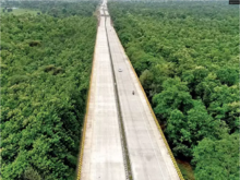
Elevated stretch of NH 44 through Pench Tiger Reserve in Madhya Pradesh.
Bengaluru–Hosur Road of this highway connects Bangalore, the capital of the state of Karnataka, and the city of Hosur, in the Krishnagiri district on the border of Karnataka and Tamil Nadu. It is a four- to six-lane highway which also has service lanes on either sides at the busier parts. Apart from being a part of the National Highway, the road is also significant because it consist of many industrial and IT business houses. The IT industrial park Electronic City is also located alongside Hosur Road.
The National Highways Authority of India has constructed a 10-kilometre-long (6.2 mi) elevated highway between Bommanahalli and Electronic City. This toll road has made travel to Electronic City a lot faster. The Bruhat Bengaluru Mahanagara Palike and the Bengaluru Development Authority have planned a series of flyovers and underpasses to make this arterial road signal-free.
Major intersections
|
|
This article contains a bulleted list or table of intersections which should be presented in a properly formatted junction table. (November 2021)
|
-

 NH 501 / NH 244 in Anantnag
 NH 144 in Domel
 NH 144A in Jammu
 NH 54 in Pathankot
 NH 3 in Jalandhar
 NH 5 in Ludhiana
 NH 7 in Rajpura
 NH 344 / NH 152 in Ambala
 NH 709A in Karnal
 NH 709 in Panipat
 NH 334B in Sonipat

 NH 9 / NH 19 / NH 48 in New Delhi
 NH 919 in Palwal
 NH 21 in Agra
 NH 23 in Dholpur