
West Godavari district or Paschima Godavari Jilla is one of the nine districts in the Coastal Andhra region of the Indian state of Andhra Pradesh. The administrative headquarters of the district is situated at Eluru. As of 2011 census of India, the district has an area of 7,742 km2 (2,989 sq mi) and a population of 3,936,966. It is bounded by Krishna district on the west, East Godavari district on the east, Bay of Bengal on the south and the state of Telangana on the north.
History
The Eastern Chalukyas ruled coastal Andhra from 700 to 1200, with Vengi, near Pedavegi village, as their capital. Historical evidences are found at the villages, Pedavegi and Guntupalli (Jilakarragudem). Eluru then became a part of the Kalinga Empire until 1471. Later it fell into the hands of the Gajapati Empire. In 1515 Sri Krishna Deva Raya captured it. After the fall of the Vijayanagara Kingdom, it was taken by the Sultan of Golkonda, Kutub Shah. On 15 April 1925, West Godavari District was formed with Eluru as its headquarters and all the district offices and regional offices were set up in Eluru city.

Eluru District Collector Office
West Godavari district was formed from old Godavari District in the year 1925 on 15 Apr. The Godavari district was renamed as East Godavari district and the new district is named as West Godavari district.
In the Madras Presidency, the District of Rajahmundry was created in 1823. It was reorganised in 1859 and was bifurcated into Godavari and Krishna districts. During British rule, Rajahmundry was the headquarters of Godavari district, which was further bifurcated into East Godavari and West Godavari districts in 1925. When the Godavari district was divided, Kakinada became the headquarters of East Godavari and Eluru became headquarters of West Godavari.
Geography
The district occupies an area of 7,742 km2 (2,989 sq mi). The district is bounded by Khammam district on the north, Bay of Bengal on the south. The Godavari River separates East Godavari district on east and Tammileru River and Kolleru Lake separates it from Krishna district on the west.:22
Rivers and topography
| S.no. | Basin | % of the area covered |
|---|---|---|
| 01 | Godavari | 20.20% |
| 02 | Yerrakaluva | 48.10% |
| 03 | Tammileru | 26.80% |
| 04 | Ramileru | 01.40% |
| 05 | Kolleru | 3.50% |

River Godavari at Kovvur
West Godavari is a flat country with a slight eastern slope along which the rivers of the district flow. The rivers in the West Godavari district generally flow from west to east. The three rivers which cut through the district are Godavari (after which the district is named), Yerrakaluva and Tammileru. Sir Arthur Cotton Barrage, Eluru canal, Vijayarai Anicut, Tammileru, Jalleru and Yerrakaluva reservoirs are the sources of irrigation.
Climate
The region has a tropical climate similar to the rest of the Coastal Andhra region. The summers (March–June) are very hot and dry while the winters are fairly pleasant. The temperatures in the summers often rise over 50 degrees during the day. The rainy season (July–December) is often the best time for tourist visits, as fields are brilliantly green with paddy crops, rivers flowing with monsoon water, and a relatively cool climate. The region has long been home to the Indian nobles due to its climate and fertile soil, and several zamindar large mansions are scattered around the Godavari area.

Caves on Dhammalingesvarasvami Hill at Guntupalle
Demographics
| Year | Pop. | ±% p.a. |
|---|---|---|
| 1901 | 919,234 | — |
| 1911 | 1,046,050 | +1.30% |
| 1921 | 1,118,436 | +0.67% |
| 1931 | 1,298,758 | +1.51% |
| 1941 | 1,465,111 | +1.21% |
| 1951 | 1,697,727 | +1.48% |
| 1961 | 1,978,257 | +1.54% |
| 1971 | 2,374,306 | +1.84% |
| 1981 | 2,873,958 | +1.93% |
| 1991 | 3,517,568 | +2.04% |
| 2001 | 3,803,517 | +0.78% |
| 2011 | 3,936,966 | +0.35% |
| source: | ||
As of 2011 Census of India, West Godavari district has a population of 3,936,966 with 1,091,525 households, which is the 11th most populous district in the state. The district’s population is approximately equal to the population of Liberia and Oregon.
In Andhra Pradesh, the West Godavari district is the 19th largest in terms of area with an area of 7,742 km2 (2,989 sq mi)(Before bifurcation) and has a population density of 509/km2 (1,320/sq mi), which is the fourth most densely populated district in the state. Its population growth rate over the decade 2001–2011 was 3.45%. West Godavari has a sex ratio of 1004 females for every 1000 males and stands it at eighth position. It stands at first position in terms of literacy rate in Andhra Pradesh with 26,52,389 (74.63%) literates. 20.6% of the district’s population lives in Uuban areas.
Economy
The gross district domestic product (GDDP) is ₹45,963 crore (US$6.4 billion) and it contributes 8.8% to the gross state domestic product (GSDP). For the FY 2013–14, the per capita income at current prices was ₹86,974 (US$1,200).
Paddy, banana, sugarcane, and coconut are the main agricultural products cultivated in the district. The agriculture sector contributes ₹18,385 crore (US$2.6 billion), industries contribute ₹7,086 crore (US$990 million), and services contribute ₹20,491 crore (US$2.9 billion) to GDDP. The major products contributing to the gross value added (GVA) of the district from agriculture and allied services are paddy, sugarcane, banana, coconut, milk, meat and fisheries. The GVA to the industrial and service sector is contributed from construction, electricity, manufacturing, unorganised trade, and transport.
Cashew nut, mango and tobacco are other important production from the district. Shrimp production is also a main activity along with pisciculture. The woolen pile carpet industry in Eluru produces eco-friendly carpets from wool that are exported.
Culture

Culture and traditions at Kalavalapalli village in West Godavari district
Telugu is the most widely spoken language. Vedas, which has oral heritage recognition from by UNESCO are taught at Sri Venkateswara Veda Patasala of I.Bhimavaram village in the district. The district is well known for its wool-pile carpets and hand woven products.

Dwaraka Tirumala Temple devotees
Tourism and landmarks
There are many landmarks and tourism destinations in the district. Eluru is the largest city of the district with many destinations related to Buddhists and Archeological importance such as Guntupalli Caves near the city. Eluru city hosts a 74-foot high Buddha statue in the heart of the city.

Buddha Park at Eluru
Some of the religious destinations include, Dwaraka Tirumala known with the name as Chinna Tirumala, Pancharama Kshetras of Palakollu and Bhimavaram. Other destinatins of tourism importance are Perupalem Beach at Narasapuram, the Kolleru Lake being the largest fresh water in the country and a bird sanctuary, Sir Arthur Cotton Barrage and Havelock Bridge. The Government of Andhra Pradesh is keen in developing Rajahmundry Airport as international airport and thus the district will get a major boost to tourism. Heli tourism is also introduced from Rajahmundry Airport to see tourist places in Districts of Godavari. Polavaram Project will become another tourist attraction in the district.
Administrative divisions

West Godavari revenue divisions map
The district has five revenue divisions, namely Eluru, Jangareddigudem, Kovvur, Kukunuru and Narasapuram. These revenue divisions are divided into 48 mandals in the district. These 48 mandals consists of 881 villages, 1 municipal corporation, 8 municipalities and 5 census towns. Eluru is the only municipal corporation, 7 municipalities include, Kovvur, Narasapuram, Nidadavolu, Palakollu, Tadepalligudem, Tanuku, Bhimavaram, Jangareddigudem and the 5 census towns are Dwarakatirumala, Sanivarapupeta, Satrampadu, Gavaravaram and Tangellamudi.:22–23,54
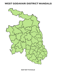
Mandals map
Mandals
The list of 48 mandals in West Godavari district under five revenue divisions are listed in the following table::22–23
| # | Eluru division | Jangareddygudem Division |
Kovvur Division | Kukunuru Division | Narasapuram Division |
|---|---|---|---|---|---|
| 1 | Bhimadole | Buttayagudem mandal | Attili | Kukkunoor | Achanta |
| 2 | Chintalapudi | Gopalapuram | Chagallu | Velerupadu | Akiveedu |
| 3 | Denduluru | Koyyalagudem | Devarapalle | Bhimavaram | |
| 4 | Dwaraka Tirumala | Jangareddigudem | Iragavaram | Kalla | |
| 5 | Eluru | Jeelugu Milli | Kovvur | Undi | |
| 6 | Ganapavaram | Polavaram | Nidadavolu | Mogalthur | |
| 7 | Kamavarapukota | Penugonda | Narasapuram | ||
| 8 | Lingapalem | Peravali | Palakoderu | ||
| 9 | Nallajerla | Penumantra | Palakollu | ||
| 10 | Nidamarru | Tallapudi | Poduru | ||
| 11 | Pedapadu | Tanuku | Veeravasaram | ||
| 12 | Pedavegi | Undrajavaram | Yelamanchili | ||
| 13 | Pentapadu | ||||
| 14 | T.Narasapuram | ||||
| 15 | Tadepalligudem | ||||
| 16 | Ungutur |
Erstwhile Talukas
Before Formation of Mandals, Administration was done through Taluka system. Erstwhile Talukas in district are given below.
In 1978, the number of talukas in west Godavari district was increased from 8 to 19. Later in 1985, 19 Talukas were divided into 46 mandals.
In 2014, according to Polavaram Ordinance, 2 mandals from Telangana were merged with West Godavari District. So total mandals numbers increased to 48
| S.No. | Erstwhile Talukasin 1971 | New TalukasFormed in 1985 | New MandalsFormed in 1985 |
|---|---|---|---|
| 1 | Eluru | Eluru | Eluru, Pedapadu, Pedavegi, |
| Bhimadole | Bhimadole, Dwaraka Tirumala, Denduluru, | ||
| 2 | Chintalapudi | Chintalapudi | Chintalapudi, T.Narsapuram, Lingapuram, Kamavarapukota, |
| 3 | Polavaram | Polavaram | Polavaram, Buttayagudem, jeelugumilli, Koyyalagudem , Jangareddygudem |
| 4 | Kovvur | Kovvur | Kovvur, Devarapalli, Chagallu, Nidadavole |
| Gopalapuram | Gopalapuram, Tallapudi, Koyyalagudem , Jangareddygudem , | ||
| 5 | Tadepalligudem | Tadepalligudem | Tadepalligudem, Nallajerla, Unguturu |
| Ganapavaram | Ganapavaram, Unguturu , Nidamarru, Pentapadu, | ||
| 6 | Tanuku | Tanuku | Tanuku, Undrajavaram, Peravali, |
| Penumantra | Penumantra, Penugonda, Atili, Iragavaram, | ||
| 7 | Narsapuram | Narsapuram | Narsapuram, Mogalthooru, Yelamanchili, |
| Poduru | Poduru, Palakollu, Achanta, | ||
| 8 | Bhimavaram | Bhimavaram | Bhimavaram, Palakoderu, Veeravasaram, |
| Akiveedu | Akiveedu, Undi, Kalla |
Cities and towns
|
Largest cities or towns in West Godavari District As per the 2011 Census
|
|||||||||
|---|---|---|---|---|---|---|---|---|---|
| Rank | Division | Pop. | |||||||
 Eluru  Bhimavaram |
1 | Eluru | Eluru Division | 250,834 |  Tadepalligudem  Palakollu |
||||
| 2 | Bhimavaram | Narasapuram Division | 146,961 | ||||||
| 3 | Tadepalligudem | Eluru Division | |||||||
| S.No. | Municipal Body | Civic Status of town | MunicipalityFormation Year | 2011 CensusPopulation | 2001 CensusPopulation | 1991 CensusPopulation | 1981 CensusPopulation |
|---|---|---|---|---|---|---|---|
| 1 | Eluru | Municipal Corporation | 1866 | 250,834 | 215,804 | 212,866 | 168,154 |
| 2 | Bhimavaram | Municipality Grade – Selection | 1948 | 146,961 | 142,064 | 121,314 | 101,894 |
| 3 | Tadepalligudem | Municipality Grade – Selection | 1958 | 130,348 | 102,622 | 88,878 | 62,574 |
| 4 | Palakollu | Municipality Grade – 1 | 1919 | 104,216 | 76,308 | 56,969 | 46,146 |
| 5 | Tanuku | Municipality Grade – 1 | 1979 | 77,962 | 72,970 | 62,913 | 53,618 |
| 6 | Narsapuram | Municipality Grade – 1 | 1956 | 58,770 | 58,604 | 56,362 | 46,033 |
| 7 | Jangareddygudem | Municipality Grade – 2 | 2011 | 48,994 | 39,021 | 28,175 | 25,056 |
| 8 | Nidadavole | Municipality Grade – 2 | 1964 | 43,809 | 43,143 | 41,101 | 31,022 |
| 9 | Kovur | Municipality Grade – 3 | 1965 | 39,667 | 39,327 | 36,061 | 28,756 |
| 10 | Akiveedu | Nagar Panchayat | 2020 | 32,412 | 24,259 | 29,421 | 21,317 |
| 11 | Chintalapudi | Nagar Panchayat | 2020 | 25,952 |
| S.No. | Town | Civic Status of Town | 2011 CensusPopulation |
|---|---|---|---|
| 2 | Polavaram | Grama Panchayat | 13,861 |
| 3 | Bhimadole | Grama Panchayat | 13,669 |
| 4 | Ganapavaram | Grama Panchayat | 11,749 |
| 5 | Gopalapuram | Grama Panchayat | 11,573 |
| 6 | Penumantra | Grama Panchayat | 10,658 |
| 7 | Poduru | Grama Panchayat | 9,578 |
| S.No. | Town | Civic Status of Town | 2011 CensusPopulation |
|---|---|---|---|
| 1 | Dwaraka Tirumala | Census Town | 5,543 |
Constituencies
There are three parliamentary and 15 assembly constituencies in the district. The parliamentary constituencies are Eluru, Narsapuram and Rajahmundry.
The Assembly constituencies are:
- Achanta
- Bhimavaram
- Chintalapudi (SC)
- Denduluru
- Eluru
- Gopalapuram
- Kovvur
- Nidadavole
- Narsapur
- Palakollu
- Polavaram (ST)
- Tadepalligudem
- Tanuku
- Undi
- Unguturu
Transport
Roadways
The total road length of state highways in the district is 1,229 km (764 mi). The district relies mostly on public transport such as, buses of APSRTC operating from all parts of the district. Most of the major highways and national highways pass through major towns in the district such as, AH 45, NH-16, NH-216A, National Highway 516D (India).
Railways
South Central Railway division of Indian Railways operates many passenger and freight transport. Howrah-Chennai main line, Vijayawada–Nidadavolu loop line and Bhimavaram–Narasapuram branch lines are the major lines and sections that provide rail connectivity in the district.Kovvur-Bhadrachalam Railway line and Kotipalli-Narsapur Railway line are the major railway projects in the district.
Airways
Tadepalligudem Airport is the only airport in the district, but it is not operational. Rajahmundry Airport is present adjacent to West Godavari. People here are demanding Government to develop Rajahmundry Airport as an international airport. Government is also keen in developing the airport as international airport. Heli Tourism is introduced from Rajahmundry Airport to see tourist places in Godavari districts.
Waterways
National Waterway 4 passes through the district and connects Puducherry with Kakinada and Rajahmundry via Tadepalligudem, Eluru. It has access to Bay of Bengal at Narsapuram. According to AP State Reorganisation Act, Government is constructing Narsapur Port.
Education
The primary and secondary school education is imparted by government, aided and private schools, under the School Education Department of the state.As per the school information report for the academic year 2015–16, there are a total of 4,408 schools. They include 19 government, 2,664 mandal and zilla parishads, 1 residential, 1,344 private, 3 Kasturba Gandhi Balika Vidyalaya (KGBV), 208 municipal and 169 other types of schools.[31] The total number of students enrolled in primary, upper primary and high schools of the district are 522,793.
Universities
- National Institute of Technology, Tadepalligudem (NIT, Tadepalligudem)
- Dr. Y.S.R. Horticultural University, Venkataramannagudem, Tadepalligudem
- Adikavi Nannayya University Campus at Tadepalligudem