
Bhubaneswar is the capital and largest city of the Indian state of Odisha. The region, especially the old town, was historically often depicted as Ekamra Khetra (area (kshetra) adorned with mango trees (ekamra)). Bhubaneswar is dubbed the “Temple City”—a nickname earned because of the 700 temples which once stood there. In contemporary times, it has emerged as an education hub and an attractive business destination.
Although the modern/ city of Bhubaneswar was formally established in 1948, the history of the areas in and around the present-day city can be traced to the 7th century BCE and earlier. It is a confluence of Hindu, Buddhist and Jain heritage and includes several Kalingan temples, many of them from 6th-13th century CE. With Puri and Konark it forms the ‘Swarna Tribhuja’ (“Golden Triangle”), one of eastern India’s most visited destinations.
Bhubaneswar replaced Cuttack as the capital on 19 August 1949, 2 years after India gained its independence from Britain. The modern city was designed by the German architect Otto Königsberger in 1946. Along with Jamshedpur and Chandigarh, it was one of modern India’s first planned cities. Bhubaneswar and Cuttack are often referred to as the ‘twin cities of Odisha’. The metropolitan area formed by the two cities had a population of 1.7 million in 2011. Recent data from the United Nations released in 2016 states that Bhubaneswar’s metro area has a population of around a million people. Bhubaneswar is categorised as a Tier-2 city. Bhubaneswar and Rourkela are the only cities in smart city mission from Odisha.
Etymology
Bhubaneswar is the anglicisation of the Odia name “Bhubaneśwara”(ଭୁବନେଶ୍ୱର), derived from the word Tribhubaneśwar (ତ୍ରିଭୁବନେଶ୍ୱର), which literally means the Lord (Iśwar) of the Three Worlds (Tribhuban), which refers to Shiva.
History

Remains of the ancient city of Sisupalagada, on the outskirts of Bhubaneswar, dated to 7th century BCE
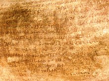
Hathigumpha inscriptions at the Udayagiri and Khandagiri caves near Bhubaneswar
Bhubaneswar stands near the ruins of Sisupalgarh, the ancient capital of the erstwhile province of Kalinga. Dhauli, near Bhubaneswar was the site of the Kalinga War (c. 262-261 BCE), in which the Mauryan emperor Ashoka invaded and annexed Kalinga. One of the most complete edicts of the Mauryan Emperor, Ashoka, dating from between 272 and 236 BCE, remains carved in rock, 8 kilometres (5.0 mi) to the southwest of the modern city. After the decline of the Mauryan empire, the area came under the rule of Mahameghavahana dynasty, whose most well-known rule is Kharavela. His Hathigumpha inscription is located at the Udayagiri and Khandagiri Caves near Bhubaneswar. The area was subsequently ruled by several dynasties, including Satavahanas, Guptas, Matharas, and Shailodbhavas.
In the 7th century, Somavamshi or Keshari dynasty established their kingdom in the area, and constructed a number of temples. After the Kesharis, the Eastern Gangas ruled Kalinga area until the 14th century CE. Their capital Kalinganagara was located in present-day Bhubaneswar City. After them, Mukunda Deva of the Bhoi dynasty – the last Hindu ruler of the area until the Marathas – developed several religious buildings in the area. Most of the older temples in Bhubaneswar were built between 8th and 12th centuries, under Shaiva influence. The Ananta Vasudeva Temple is the only old temple of Vishnu in the city. In 1568, the Karrani dynasty of Afghan origin gained control of the area. During their reign, most of the temples and other structures were destroyed or disfigured.
In the 16th century, the area came under pachamani Mughal control. The Marathas, who succeeded the Mughals in the mid-18th century, encouraged pilgrimage in the region. In 1803, the area came under British colonial rule, and was part of the Bengal Presidency (until 1912), Bihar and Orissa Province (1912-1936) and Orissa Province (1936-1947). The capital of the British-ruled Orissa Province was Cuttack, which was vulnerabile to floods and suffered from space constraints. Because of this, on 30 September 1946, a proposal to move the capital to a new capital was introduced in the Legislative Assembly of the Odisha Province. After independence of India, the foundation of the new capital was laid by Prime Minister Jawaharlal Nehru on 13 April 1948.
The name of the new capital came from “Tribhubaneswara” or “Bhubaneswara” (literally “Lord of the Earth”), a name of Shiva, the deity of the Lingaraja temple. The Legislative Assembly of Odisha was shifted from Cuttack to Bhubaneswar in 1949. Bhubaneswar was built as a modern city, designed by German architect Otto Königsberger with wide roads, gardens and parks. Though part of the city followed the plan, it grew rapidly over the next few decades, outstripping the planning process. According to the first census of independent India, taken in 1951, the city’s population was just 16,512. From 1952 to 1979, it was administered by a Notified Area Council or a nagar panchayat; a municipality was established only on 12 March 1979. By the 1991 census, the population of Bhubaneswar had increased to 411,542. Accordingly, on 14 August 1994, the Bhubaneswar Municipal Corporation was established.
Geography
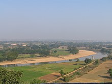
Daya River at the foothills of Dhauli
Bhubaneswar is in Khordha district of Odisha. It is in the eastern coastal plains, along the axis of the Eastern Ghats mountains. The city has an average altitude of 45 m (148 ft) above sea level. It lies southwest of the Mahanadi River that forms the northern boundary of Bhubaneswar metropolitan area, within its delta.

City of Bhubaneswar from Khandagiri hill
The city is bounded by the Daya River to the south and the Kuakhai River to the east; the Chandaka Wildlife Sanctuary and Nandankanan Zoo lie in the western and northern parts of Bhubaneswar, respectively.
Bhubaneswar is topographically divided into western uplands and eastern lowlands, with hillocks in the western and northern parts. Kanjia lake on the northern outskirts, affords rich biodiversity and is a wetland of national importance. Bhubaneswar’s soils are 65 per cent laterite, 25 per cent alluvial and 10 per cent sandstone. The Bureau of Indian Standards places the city inside seismic zone III on a scale ranging from I to V in order of increasing susceptibility to earthquakes. The United Nations Development Programme reports that there is “very high damage risk” from winds and cyclones. The 1999 Odisha cyclone caused major damage to buildings, the city’s infrastructure and cost many human lives. Floods and waterlogging in the low-lying areas have become common due to unplanned growth.

Bhubaneswar schematic tourist map
Urban structure

Rajpath, Bhubaneswar

Pathani Samanta Planetarium Bhubaneswar
The Bhubaneswar urban development area consists of the Bhubaneswar Municipal Corporation area, 173 revenue villages and two other municipalities spread over 1,110 km2 (430 sq mi). The area under the jurisdiction of the Bhubaneswar Municipal Corporation covers 186 square kilometres (72 sq mi). The city is somewhat dumbbell-shaped with most of the growth taking place to the north, northeast and southwest. The north–south axis of the city is widest, at roughly 22.5 kilometres (14.0 mi). Growth in the east is restricted due to the presence of Kuakhai River and by the wildlife sanctuary in the northwestern part. The city can be broadly divided into the old town, planned city (or state capital), added areas and outer peripheral areas. It is subdivided into Units and Colonies.
The old town or “Temple Town”, the oldest part of the city, is characterised by many temples, including the Lingaraja, Rajarani and Muktesvara temples, standing alongside residential areas. This area is congested, with narrow roads and poor infrastructure. Among neighbourhoods in the old town are Rajarani Colony, Pandaba Nagar, Brahmeswara Bagh, Lingaraja Nagar, Gouri Nagar, Bhimatangi and Kapileswara. The planned city was designed in 1948 to house the capital. It is subdivided into units, each with a high school, shopping centres, dispensaries and play areas. While most of the units house government employees, Unit V houses the administrative buildings, including the State Secretariat, State Assembly, and the Raj Bhavan. Private residential areas were later built in other areas of the planned city, including Saheed Nagar and Satya Nagar. Unit I, popularly known as the Market Building, was formed to cater to the shopping needs of the new capital’s residents. Later, markets and commercial establishments developed along the Janpath and Cuttack-Puri Road at Saheed Nagar, Satya Nagar, Bapuji Nagar and Ashok Nagar. A dedicated institutional area houses educational and research institutes, including Utkal University, the Institute of Physics, the Institute of Minerals and Materials Technology and Sainik School. Indira Gandhi Park, Gandhi Park and the Biju Patnaik Park are located in the unit.
The added areas are mostly areas lying north of National Highway 5, including Nayapalli, Jayadev Vihar, Chandrasekharpur and Sailashree Vihar, #Niladri vihar which were developed by Bhubaneswar Development Authority to house the growing population. With the development of the new areas such as Chandrasekharpur the city is now divided roughly into North(newer areas) and South Bhubaneswar (older areas) by the NH-5 highway.
The peripheral areas are outside the municipal boundary or have subsequently been included within the extended boundary, including Tomando, Patia and Raghunathpur. Most of these areas were developed in a haphazard manner, without proper planning. The Master Planning Branch of the Bhubaneswar Development Authority developed the Comprehensive Development Plan (CDP) in 2010. According to the Odisha Development Authorities Act, 1982, the Development Authority has control over the planning for municipal areas. Apart from the CDP, BDA has also created Zonal Development Plans for some of the areas under the CDP. Bhubaneswar secured the top rank in the Smart city list in India.

Deras Dam
Climate

Meteorological Centre, Bhubaneswar
Bhubaneswar has a tropical savanna climate, designated Aw under the Köppen climate classification. The annual mean temperature is 27.4 °C (81.3 °F); monthly mean temperatures are 22–32 °C (72–90 °F). Summers (March to June) are hot and humid, with temperatures in the low 30s C; during dry spells, maximum temperatures often exceed 40 °C (104 °F) in May and June. Winter lasts for only about ten weeks, with seasonal lows dipping to 15–18 °C (59–64 °F) in December and January. May is the hottest month, when daily temperatures range from 32–42 °C (90–108 °F). January, the coldest month, has temperatures varying from 15–28 °C (59–82 °F). The highest recorded temperature is 46.7 °C (116.1 °F), and the lowest is 8.2 °C (47 °F).
Rains brought by the Bay of Bengal branch of the south west summer monsoon lash Bhubaneswar between June and September, supplying it with most of its annual rainfall of 1,638 mm (64 in). The highest monthly rainfall total, 404 mm (16 in), occurs in August.
| hideClimate data for Bhubaneswar (1981–2010, extremes 1952–2012) | |||||||||||||
|---|---|---|---|---|---|---|---|---|---|---|---|---|---|
| Month | Jan | Feb | Mar | Apr | May | Jun | Jul | Aug | Sep | Oct | Nov | Dec | Year |