
Bongaigaon (/bɒŋˈɡaɪɡaʊ/ (![]() listen)) is a major city in the Indian state of Assam. Its urban area spans across Bongaigaon and Chirang district. The City also acts as the gateway of North-East Frontier Railway Zone with its New Bongaigaon Junction railway station, second biggest railway station in North-East India. It also acts as the district headquarters of Bongaigaon district cum commercial and industrial hub of west part of the state of Assam. Bongaigaon is one of the most populated urban agglomerations in Assam with line of Guwahati, Jorhat, Dibrugarh and Silchar.
listen)) is a major city in the Indian state of Assam. Its urban area spans across Bongaigaon and Chirang district. The City also acts as the gateway of North-East Frontier Railway Zone with its New Bongaigaon Junction railway station, second biggest railway station in North-East India. It also acts as the district headquarters of Bongaigaon district cum commercial and industrial hub of west part of the state of Assam. Bongaigaon is one of the most populated urban agglomerations in Assam with line of Guwahati, Jorhat, Dibrugarh and Silchar.
It was the last capital of Koch Hajo and home to many historical monuments of Koch Rajbonsghi or Kamatapuri culture. The city, divided into two parts – Old Bongaigaon and New Bongaigaon – is situated 180 kilometres (112 mi) north west of Guwahati, largest city of Assam. To meet the demands of Bodos of Assam, Bongaigaon was divided up to give way for Chirang district. Bongaigaon has a major petrochemical industry, the Indian Oil Corporation Limited (IOCL BGR). The town occupied a place in the map of Indian Railways with the establishment of the railway station in the year 1908. Most of the institutions like ITI, Bongaigaon College, Office of the Assam State Electricity Board in the early 1960s and in fact the very base of the development of the town was laid in this decade only. The development further gained momentum with the establishment of the Bongaigaon Refinery and Petrochemicals Limited (BRPL) complex in the year 1972 at Dhaligaon and also Thermal Power Plant at Salakati. Though these areas are not within the limit of Bongaigaon Municipality the town also caters to the demand of this population. The Bongaigaon Town Committee was first constituted in the year 1961 and was upgraded to a Municipal Board in the year 1977. Presently the Municipal Area consists of 25 nos. of wards covering an area of 14.31 sq m.
The city today has evolved to be one of the major commercial and business hubs of the state with growing numbers of shopping malls, restaurants, hotels, residential apartments and educational institutions. The city also serves as the base for tourism to places such as the Manas National Park. Centrally located within the state, the city depicts a vibrant Assamese township and culture, making it one of the most preferred places for local people to congregate.
Etymology
According to lore, the name ‘Bongaigaon’ derives from the words ‘bon’ (wild) and ‘gai’ (cow). In the distant past, wild cows were often a menace to villagers in this area due to which the district got its name.
History
Creation
The decision of the government of Assam was taken in 1989, to create a new district of Bongaigaon, carving out some areas of the Goalpara and Kokrajhar District with its headquarters located at Bongaigaon. On 29 September 1989, the creation of Bongaigaon District was declared by the Government of Assam with its headquarters at Bongaigaon. In 2005, Government of Assam declared Bongaigaon town as a city.

Evening Skyline of Bongaigaon City, Paglasthan
Background
The original Goalpara district was first created in 1822 by David Scott, an employee of East India Company, who was the first Commissioner of newly created North east Rangpur district headquarters at Rangpur town (now in Bangladesh) and the newly created Goalpara district was also tagged with North-east Rangpur district for administration. The erstwhile Bijni Kingdom’s area which included the undivided Garo Hills district constituted the Undivided Goalpara district area in 1822. In 1866, Garo Hills was separated from Goalpara district area and in the same year a new district named “Greater Koch Behar” was created and the residual portion of Goalpara district was withdrawn from Rangpur and tagged with Koch Behar. In 1874 a new province named Assam Valley Province was created by the British government (successor of East India Company) and Goalpara district area was withdrawn from Koch Behar and tagged with Assam Province which continues till today unless petty political gambling disturbs. Now the original Goalpara district has given birth to five districts namely (i) Goalpara (ii) Dhubri (iii) Kokrajhar (iv) Bongaigoan and (v) Chirang.
Bijni Kingdom
|
This section needs expansion. You can help by adding to it. (July 2022)
|
From the chequered historical background of this district, it was ruled by zamindars hailing from the Koch belonging to Indo-Mongoloid ethnic group of peoples right from the 15th century to the end of princely states in 1956.
Rulers of Bijni Kingdom
- Bijit Narayan (alias Chandra Narayan)
- Joy Narayan
- Shiv Narayan
- Bijoy Narayan
- Mukunda Narayan
- Haridev Narayan
- Indra Narayan
- Amrit Narayan
- Kumud Narayan
- Jogendra Narayan
- Bhairabendra Narayan
Modern era
|
This section needs expansion. You can help by adding to it. (July 2022)
|
On 14 March 1989, bombs from separatist tribal militants exploded in Bongaigaon, killing 17 and wounding at least 48.
In June 2022, heavy floods in Assam affected residents of Bongaigaon.
Administration
Bongaigaon is part of Barpeta (Lok Sabha constituency). Phani Bhusan Choudhury is the current M.L.A. of Bongaigaon constituency.
Geography
Bongaigaon is located at 26°28′37″N 90°33′30″E. Bongaigaon is situated at an average altitude of 62.6 m with the cardinal points 26028″ east latitude and 90034″ north longitude. The town is situated at a distance of 200 km west from the State Capital and occupies an important place in the communication network in Assam as well as northeast India. The New Bongaigaon railway station is a major junction connecting Assam with the rest of India. This town is also very well connected by road through the National Highway 31 B and 31C. This connectivity and the strategic location of the town in the regional set up has helped it to emerge as an important center in trade and commerce in Western Assam serving a vast hinterland. It is one of the biggest industrial towns in Lower Assam.
Climate
Bongaigaon has a borderline monsoon-influenced humid subtropical climate (Köppen Cwa) marginally too cool to be a tropical savanna climate (Aw). During the “cool” season from November to February, afternoons are warm to very warm and mornings pleasantly cool. In the “hot” season of March and April, the weather becomes hot and thunderstorm rainfalls increase in frequency to prelude the oppressive monsoon season from June to September where heavy rainfall occurs every afternoon.
| hideClimate data for Bongaigaon | |||||||||||||
|---|---|---|---|---|---|---|---|---|---|---|---|---|---|
| Month | Jan | Feb | Mar | Apr | May | Jun | Jul | Aug | Sep | Oct | Nov | Dec | Year |
| Record high °C (°F) | 30 (86) |
33 (91) |
38 (100) |
40 (104) |
38 (100) |
40 (104) |
37 (99) |
37 (99) |
37 (99) |
35 (95) |
32 (90) |
28 (82) |
40 (104) |
| Average high °C (°F) | 23 (73) |
25 (77) |
30 (86) |
31 (88) |
31 (88) |
31 (88) |
32 (90) |
32 (90) |
31 (88) |
30 (86) |
27 (81) |
24 (75) |
29 (84) |
| Average low °C (°F) | 10 (50) |
12 (54) |
15 (59) |
20 (68) |
22 (72) |
25 (77) |
25 (77) |
25 (77) |
24 (75) |
21 (70) |
16 (61) |
11 (52) |
19 (66) |
| Record low °C (°F) | −2 (28) |
−3 (27) |
4 (39) |
11 (52) |
16 (61) |
18 (64) |
20 (68) |
21 (70) |
20 (68) |
9 (48) |
0 (32) |
−1 (30) |
−3 (27) |
| Average rainfall mm (inches) | 11.4 (0.45) |
12.8 (0.50) |
57.7 (2.27) |
142.3 (5.60) |
248.0 (9.76) |
350.1 (13.78) |
353.6 (13.92) |
269.9 (10.63) |
166.2 (6.54) |
79.2 (3.12) |
19.4 (0.76) |
5.1 (0.20) |
1,715.7 (67.53) |
| Source: wunderground.com | |||||||||||||
Localities in Bongaigaon
- Mayapuri
- Borpara
- Paglasthan
- Mahabeersthan
- Chapaguri
- Dhaligaon
- New Bongaigaon
- Borsongaon
- Deuripara
- Purani Bongaigaon
- BOC Gate
- Rolling Mill
- Dolaigaon
- Notunpara
- Kukurmari
- Hatimutra
- Salbari
- New Colony (Railway)
- Old Colony (Railway)
- Salbagan
- Bhakarivita
Infrastructure
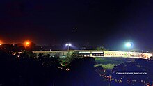
Night view of Bir Chilarai Flyover
In 2010 Bongaigaon city built a designable flyover in the city. The flyover connect three part of the city
- New Bongaigaon with West Part of Bongaigaon
- North Part of Bongaigaon City with Central Part of Bongaigaon
- New Bongaigaon with North Part of Bongaigaon City
The flyover controlled the busy railway traffic and also the road traffic of the city. Now Bongaigaon city can’t handle the whole communication of vehicle and train without the Bir Chilarai Flyover.
Socio-cultural spectrum
Apart from the prevalent common environment in the erstwhile Bijni Kingdom and undivided Goalpara district of 1822, the most striking features of Bongaigaon district are the Hilly Caves (Gumphas) and stone carvings of Jogighopa hill-rocks demonstrating the existence of Buddhist culture. The hills and the hilly rocks, the rivers, natural and man-made ponds, the deep forest, the trees, plants, and the bushes.

A park in Bongaigaon
Natural resource base
|
This section needs expansion. You can help by adding to it. (July 2022)
|
The district is part of the Brahmaputra river’s basin.
Demography
Languages spoken in Bongaigaon city (2011)
In Bongaigaon municipal board city Hindus comprise the majority by 90.73%. The majority of the city population work in service industry.
Bongaigaon city (M.C) area have a population of 139,650 as per 2011 census. Bengali is Spoken by 49,617 people, Assamese at 34,814, Hindi at 18,768 and 36,448 people speaks other languages.
Economy
Media and technology
The most popular Assamese newspaper of Assam Asomiya Pratidin is published from Bongaigaon along with Guwahati, Dibrugarh and North Lakhimpur.
Indian Oil Corporation Limited, Bongaigaon
The Bongaigaon Refinery is the eighth largest refinery of Indian Oil. Formed upon the amalgamation of Bongaigaon Refinery and Petrochemicals Limited (BRPL) with Indian Oil on 25 March. 2009, Bongaigaon refinery is situated at Dhaligaon in Chirang district of Assam, 200 km west of Guwahati.

Bongaigaon Refinery Main Gate side of National Highway No. 31 (A1)
It has two Crude Distillation Units (CDU), two Delayed Coker Units (DCU) and a Coke Calcination Unit (CCU) with a processing capacity of 2.35 million tonnes per year of crude oil. The first CDU with a capacity of 1 million tonnes per year was commissioned in 1979. The capacity was further increased to 1.35 million tonnes per year in 1986. An LPG bottling plant with a capacity of 44 million tonnes per year was also commissioned in 2003.
The refinery produces a wide range of petroleum products, namely LPG, Naphtha, MS, SKO, HSD, LDO, LSHS, LVFO, RPC, CPC, Needle coke and solvents (Petrosol and Bonmex-II) by processing Assam Crude and Ravva Crude (from the Ravva oil fields of Krishna Godavari Basin). Bongaigaon refinery has also undertaken special endeavours towards environment protection and conservation. The refinery has developed an ecological park and a pond surrounding it containing 65,000 cubic metres of water, through which the storm water drains of the plant are routed for final discharge. Another natural pond with a capacity of 30,000 cubic meters of water has developed into an environment-friendly park-cum-pond for migratory birds. In addition, a rainwater harvesting system has been installed in the Bongaigaon township complex and the installation of solar water heating systems (SWHS) and solar photovoltaic systems (streetlights) is underway.
In recognition of its green initiatives, Bongaigaon refinery has been a recipient of numerous prestigious awards, the latest being the National Award for “Prevention of Pollution” from the Ministry of Environment and Forests on 16 September 2010. The award acknowledges the Refinery’s outstanding contribution in environmental conservation and creating environmental awareness in the Bodo Territorial Autonomous District region of Assam, which is predominantly a tribal dominated area. Bongaigoan Refinery is the country’s first oil Refinery to have won this coveted honour. Last year the Refinery was honoured with the Indira Gandhi Paryavaran Puruskar by the Ministry of Environment, as well as the ‘Greentech Environment Excellence Gold Award 2008’ and the ‘Indira Gandhi Paryavarn Puraskar 2006’ for its outstanding environmental performance.

Evening view of BGR Township Gate No. 2
Bongaigaon Refinery Township (BGR Township)
BGR Township is a quarter campus of the employees of IOCL BGR. The town is located in Dhaligaon near Bongaigaon Refinery. In the township there are two schools, BGR HS School and DPS Dhaigaon. There are three luxury guest houses here. There are also two clubs, RCCC Club & Auditorium and Champa Club & Play Hub.

Mayapuri Cinema, Mayapuri City Centre
NTPC Bongaigaon
The NTPC project at Bongaigaon, NTPC Bongaigaon, a (3X250MW) is slated for commissioning. Assam will receive 300MW from Bongaigaon project. The total land requirement is 964 acres which is already available. The total project cost is estimated at Rs 40600 million.
Transport
Air
The nearest domestic and international airport is Lokopriya Gopinath Bordoloi International Airport, Guwahati.

New Bongaigaon Railway Junction (Front View)
Railways
Bongaigaon falls under the Northeast Frontier Railway zone of the Indian Railways.There are two stations in Bongaigaon – New Bongaigaon railway station (2nd largest railway junction of Assam state) and Bongaigaon (old) station. Major trains serving Bongaigaon with major cities are Dibrugarh Rajdhani Express, Poorvottar Sampark Kranti Express, Saraighat Express, Brahmaputra Mail, North-East Express, Guwahati Bangalore Express, Guwahati Ernakulam Express, Kamrup Express. It is the largest station in Western Assam after Guwahati. According to 2012 budget, New Bongaigaon Jn. is considered to be the Adarsh Station of India.

Biodiversity Special train name Science Express stands on a platform of New Bongaigaon Railway Junction

Dibrugrah-New Delhi Rajdhani Express on the platform no.3 of New BNGN Jn. Station
Construction of the 265 km (165 mi) long 5 ft 6 in (1,676 mm) broad gauge Siliguri-Jogihopa line, between 1963 and 1965, brought broad gauge railways to Assam. It also was the reason for setting up the New Bongaigaon railway station.
A new railway track from New Bongaigaon to Guwahati was commissioned in 1984.
Saraighat Bridge opened in 1962. It initially carried a metre gauge track, which was later replaced by broad gauge.
Roadways
National Highway 31 connects Bongaigaon with the states Bihar, Jharkhand and West Bengal. National Highway 37 via Naranarayan Setu from Goalpara in Assam to Dimapur in Nagaland traverses the entire length of Assam and connects Bongaigaon with almost all the major cities of Assam including the cities of Jorhat and Dibrugarh. National Highway 31C connects Bongaigaon to Guwahati and National Highway 37 also connects Bongaigaon with Guwahati. There are many bus terminals like ASTC Bongaigaon, Barpara Private, Chapaguri Bus Stand. There are many buses which connect Bongaigaon with major cities of Assam like Basugaon, Mangaldai, Gossaigaon, Dhubri, Barpeta, Tezpur, Goalpara, Abhayapuri, Kokrajhar, Bijni, Siliguri, Cooch Behar and Guwahati etc.
Healthcare
There are 9 hospitals in Bongaigaon city, the list follows as:

Bongaigaon Civil Hospital, Hatimura (OG)
- S M Hospital
- Lower Assam Hospital And Research Centre
- Swagat Hospital
- Chilarai Nursing Home
- Arogya Hospital and Research Centre
- St. Augustine’s Hospital
- Bongaigaon Civil Hospital
- Kajalgaon Civil Hospital
- New Bongaigaon Railway Hospital
- Bongaigaon Refinery Hospital
Education
The number of schools continued to increase after the refinery started functioning.

Bongaigaon Refinery HS School, Dhaligaon
Schools in Bongaigaon
- Bongaigaon Refinery HS School, Dhaligaon (previously BRPL Vidyalaya)
- Birjhora Higher Secondary School
- Bongaigaon Railway Higher Secondary School
- DPS Dhaligaon, Bongaigaon Refinery
- New Bongaigaon H.E School .
- Kendriya Vidyalaya New Bongaigaon
- Bongaigaon Higher Secondary School English Medium (Menon)
- Santi Dham Kalibari High School
- Vivekananda Vidyapith Higher Secondary School
- Hindi Higher Secondary School
- Little Flower School, Chapaguri
- St. Albert’s High School, New Bongaigaon
- Holy Child EM High School
- Jnanodoy Higher Secondary School
- Gyanadai Jatiya Vidyalaya
- Dhaligaon L.P School, Dhaligaon
- Dhaligaon High School, Dhaligaon
- Chapaguri M.E School, Chapaguri
- Shankardev Sishuneketan
- Shankardev Academy, Borpara
- Trinity English Medium
- Netaji Bidyaniketan M.E. School, Netaji Nagar, Paulpara
- Bongaigaon Model School
- LB ACCADEMY
- Morning Glory School
- Pranab Academy
- Pranab Vidyapeeth, Mahabirsthan
- Girls’ M.V. School
- Borpara L.P School
- Hindi High School, side of flyover, Mahabeersthan
- St. Francis D’Assisi School, Nayapara
- North Salmara Buniyadi School
- Chalantapara H.S. School
- Kabaitari Jatiya Vidyalaya
- JB High School, Salbari
- Netajee Vidyapith, BG Colony
- Netajee Vidyapith, Natunpara
- Mulagaon High School
- Lal Bahadur Shastri Vidyapith, Salbari
- Jawaharlal Navoday Vidyapith, Mulagaon
- St. Xavier’s Public School
- Chilarai Jatiya Vidyalaya, Aatugaon
- Sungaputa Nimna Buniyadi School.
- Jnanpith Jatiya Vidyalaya, Jogighopa.
- G.M.High School, Jogighopa
- K.R.G. Hindi High School, Bongaigaon
- P.K.M. English Medium School, Dhaligaon
- St. Aloysius Semiary(Religious), Chapaguri
But seeing the results for quite a few years, the number of schools are on rise.

DPS Dhaligaon
46. Chaprakata popragaon high school, chaprakata
Kids activity school
- Dafodill
- Sunflower
- KidZEE
- Euro Kids
- Kinder Garden, Natunpara
- Kinder Garden, Dhaligaon (inside BGR Township)
- Kids Model School
- Morning Glory Kids
- Kids veda
Colleges

Gate to Bongaigaon College
- Bongaigaon College, established in 1964
- Bongaigaon Polytechnic
- Birjhora Mahavidyalaya (Degree Science College)
- Bongaigaon Law College
- Bongaigaon B.Ed. College
- Birjhora Kanya Mahavidyalaya
- Upendranath Brahma College, Bongaigaon-783385
- SAI Institute (A college for professional excellence)
- DIET, Majgaon
Junior Colleges
- Gyanjyoti Jr. College (Arts & Commerce)
- Bongaigaon Jr. College
- BGR Higher Secondary
- Don Bosco Junior College
- Sankar Madhab Academy
Recreation
Shopping & Entertainment
Mayapuri Cinema, as seen from outside
The city host two movie theatres (Cinema Hall) — Jolly Max Theater and Mayapuri Cinema. Prakash Cinema which is situated in the north part of the town has been closed down.
There are various public markets in the city for the different part of the city, those are mainly Boro Bazaar, (Borpara), Balaji Market (B.O.C Gate), China Market (New Bongaigaon), Tuniapaar Bazaar (near New Bongaigaon railway station), Dhaligaon Bazaar (near Bongaigaon Refinery and Petrochemicals Limited), Chapaguri Hat (near NH-31, Gate of Bongaigaon City), Dangtola Bazaar and Railway Market New Bongaigaon, Bazar India(BOC gate), Vishal Mega Mart (near prakash hall), Reliance Trends, Bongaigaon (near Mayapuri cinema hall), 1 India Family Mart, Bongaigaon (near Lower Assam Hospital), Cygnett Park Meghna( NH27, Chapaguri, a 4 star hotel), etc.
Places of interest
Nakkati Pahar
The Nakkati Hill or we can say the hill that is hidden among the hills in the interiors of Bongaigaon district area near Dewangaon, has its peak as a cut-nose-shape. Situated at a height of about 300 meters from ground level, it has views of the surroundings.
Koyakujia Bil

View of Koya Kujia lake
Koya Kujia Eco Park, a natural body of water converted into an eco park by the district rural development agency of Bongaigaon, is a tourist attraction situated near Abhayapuri about 15 kilometers from Bongaigaon. It attracts thousands of local and foreign tourists every season ever since its opening in September 2008. The vast water land consisting of small islands flourish with myriad flora & fauna. Many migratory birds migrate to this place.
Bagheswari Temple
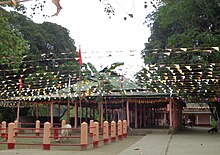
Bagheswari Temple
Bagheshwari Temple is a temple devoted to Goddess Durga for followers of Hindu religion in Western Assam. The temple is located in the middle part of the city. It is centrally located in the place Borpara of the city. It is said that the king of Abhayapuri decided to build a temple after a sword was found at the spot. It also under a spot in the nearby hill called Bagheswari pahar which has a cave inhabiting tigers as late as the middle of the 20 th century and hence comes the name devoted to the Tiger (Bagh)
Bagheswari Hill
Bagheswari hill is situated in the middle of the city. From the highest point of the hill, a view can be seen of the whole city. Here is also a Shiv temple in the highest point.
Jogighopa and Pancharatna

Pancharatna temple
Jogighopa and Pancharatna are two historic sites situated on either bank of Brahmaputra river, in Assam. Pancharatna lies on the southern bank and is about 160 kilometers west of Guwahati by road. Jogighopa lies on the northern bank and is about 212 km from Guwahati by Northern Highways. Some cubicles which are cut on step rocks, supposed to have been used by monks for meditation in the medieval period, are found here. Most of the caves found in here are very small. Pancharatna boasts some ruins of a post-Gupta temple and some also rock cut ruins including a monolithic Buddhist stupa.
Kachugaon Game Reserve
Kachugaon Game Reserve is located in Kachugaon of Bongaigaon district of Assam. It is a protected area under the forest department of Assam. Kachugaon covers an area of around 214 km2 and has rare and endangered species such a gaur, golden langur, spotted deer and elephant.
Kakoijana Reserved Forest

A golden langur in Kakoijana reserved forest
Now it has been upgraded as a wildlife sanctuary, covering an area around 20 km2. It is famous for its golden langur and birds
Aai River Sand
Aai is a sub river of The mighty Brahmaputra. Its sandy bank is a picnic point. The border of Assam and Bhutan hill area is very amazing for the tourists.
Roumari Dam
Roumari Dam is well known Dam of the whole Western Assam. It is 10 km away from the city. It is picnic spot for the people of Assam. It is also in the border of India and Bhutan. The Dam is on Aai river.
Bongaigaon City Garden
This garden includes a big pool for the boating. Here is also much of playing things for the children of the city. It is also a well-known place of the city.
Manas River Point
The Manas River is a transboundary river in the Himalayan foothills between southern Bhutan and India. It is the largest river system of Bhutan, among its four major river systems; the other three are Amo Chu or Torsa, Wong Chu or Raidak, and Mo Chu or Sankosh. It is met by three other major streams before it again debouches into India in western Assam. The total length of the river is 376 kilometres (234 mi): it flows through Bhutan for 272 kilometres (169 mi) and then through Assam for 104 kilometres (65 mi) before it joins the mighty Brahmaputra River at Jogighopa. Another major tributary of the Manas, the Aie river joins it in Assam at Bangpari.
The river valley has two major reserve forest areas, namely the Royal Manas National Park (43,854 hectares (108,370 acres), established in 1966) in Bhutan and the contiguous Manas Wildlife Sanctuary (391,000 hectares (970,000 acres) in 1955 increased to 95,000 hectares (230,000 acres) in December 1985) encompassing Project Tiger Reserve, an Elephant Reserve and a Biosphere Reserve, which constitutes a UNESCO World Heritage Site declared in December 1985.
Sri Surya Pahar

Gateway of Sri Surya Pahar
Sri Surya Pahar is a significant but relatively unknown archaeological site in Assam, India. The site is a hilly terrain where several rock-cut Shivalingas, votive stupas and the deities of Hindu, Buddhist and Jain pantheon are scattered in an area of about one km. The site is centred on the hills (Pahar) of Sri Surya which is profusely filled up with Shiva Lingas (Lingam). A popular legend is 9 lakh 90 thousand 900 hundred 99 Shiva Lingas were engraved here by Vyasa in order to build up a second Kashi (where there were 1,00000 Shiva Lingas) and once it was one of the holiest pilgrimage sites in the region. There is no historical evidence exactly how many Lingams once dotted these hills, but still, there are hundreds of them, from tiny to large in size, scattered everywhere at the foot of the hill and covering the extensive area after centuries of neglect and pilferage. The exact figure of the Lingas (and also other deities and relics) in the hill is yet to be counted scientifically.
Manas National Park
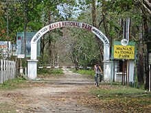
Manas National Park
Bongaigaon city is the entry point for the Manas National Park. Manas National Park or Manas Wildlife Sanctuary is a national park, UNESCO Natural World Heritage Site, a Project Tiger reserve, an elephant reserve and a biosphere reserve in Assam, India. Located in the Himalayan foothills, it is contiguous with the Royal Manas National Park in Bhutan. The park is known for its rare and endangered endemic wildlife such as the Assam roofed turtle, hispid hare, golden langur and pygmy hog. Manas is famous for its population of the wild water buffalo.
Lalmati-Duramari Ganesh Temple

Lalmati-Duramari Ganesh Temple
The Lalmati-Duramari Ganesh Temple near Abhayapuri town under North Salmara Sub-Division is one of the oldest temples of the state.
The historicity of the images are yet to be ascertained. But after a study of the stone carving and modes related to the carved idols, archeologists opine that the temple and images belong to the 8th to 10th centuries.
There are three views advanced as the reason for the destruction of the temple. The first view has it that earthquakes during the 8th and 10th centuries destroyed the temple and its images, while according to the second view, Kalapahar who revolted against worshippers and priests, destroyed the temple along with other temples and images in the North-East. The third view has it that Burmese (Maan) invaders who camped at Malegarh (Manegarh) hills destroyed the temple along with the idols. But it seems that earthquake has been the prime cause of the destruction of the temple.
Rock Cut Caves
The best specimens of the architecture of the Salasthambha period are the remains of the five rock-cut caves at Jogighopa on the bank of the Brahmaputra in the district of Bongaigaon. These are the unique examples of rock-cut architecture in Assam. Though these rock-cut caves are not of such architectural interest as those in Western India, these remains at Jogighopa are the clear evidence of the fact that Assam was not outside the movement of this particular type of art developed in India as it will be seen from the description of the best-preserved cave noticed at Jogighopa.
The cave measures 2.60 m breadth, 1.8 metre in depth and 1.90 meters in height and also has a roughly rounded ceiling and in front a verandah 75 cm long by 35 cm broad. A platform of brick and mud masonry is found inside which is obviously a later addition. A chase running across the entire breath of the cave on the top serves to drain away rainwater from the facade. Flights of steps have been cut into the rock on either side and ledge on the top diverts the rainwater from the facade. The cave bears no sculptural designs. The other caves at the site have no flights and verandah and are smaller in size than the best preserved one.
This architectural site has been taken up by the Archaeological Survey of India for preservation.
Sports

Chilarai Indoor Stadium
The multipurpose Chilarai Stadium is situated at Barshangaon, on the outskirts of Bongaigaon town. The town has an indoor stadium named Chilarai Indoor Stadium and Swimming pool at Borpara and a Mini Stadium Near Chapguri Road.