
Jammu district is an administrative district of the Jammu division of Indian-administered Jammu and Kashmir in the disputed Kashmir region. It is the most populous district in the Jammu division.
|
Jammu district
|
|
|---|---|
|
District of Jammu and Kashmir administered by India[1]
|
|
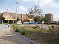
Bahu Fort, Jammu, India
|
|

Wikimedia | © OpenStreetMap
Interactive map of Jammu district
|
|
![Jammu district is in the Jammu division (shown with neon blue boundary) of Indian-administered Jammu and Kashmir (shaded in tan in the disputed Kashmir region[1]](https://upload.wikimedia.org/wikipedia/commons/thumb/6/6e/Kashmir_region._LOC_2003626427_-_showing_Jammu_division_administered_by_India_in_neon_blue.jpg/250px-Kashmir_region._LOC_2003626427_-_showing_Jammu_division_administered_by_India_in_neon_blue.jpg)
Jammu district is in the Jammu division (shown with neon blue boundary) of Indian-administered Jammu and Kashmir (shaded in tan in the disputed Kashmir region[1]
|
|
| Coordinates (Jammu): 32.73°N 74.87°E | |
| Administering country | India |
| Union territory | Jammu and Kashmir |
| Division | Jammu Division |
| Headquarters | Jammu |
| Tehsils |
|
| Government | |
| • District Magistrate | Avny Lavasa (IAS) |
| • Lok Sabha constituencies | Jammu (Lok Sabha constituency) |
| • Vidhan Sabha constituencies | 11 |
| Area
[2]
|
|
| • Total | 2,342 km2 (904 sq mi) |
| • Urban | 252.13 km2 (97.35 sq mi) |
| • Rural | 2,089.87 km2 (806.90 sq mi) |
| Population
(2011)
|
|
| • Total | 1,529,958 |
| • Density | 650/km2 (1,700/sq mi) |
| • Urban | 765,013 |
| • Rural | 764,945 |
| Demographics | |
| • Literacy | 83.45% |
| • Sex ratio | 880 |
| Time zone | UTC+05:30 (IST) |
| Vehicle registration | JK-02 |
| Website | http://jammu.nic.in/ |

Administrative divisions
Jammu District has 7 Sub-Divisions:
- Jammu South
- Jammu North
- R.S. Pura
- Marh
- Akhnoor
- Chowki Choura
- Khour
There are 21 tehsils:[5]
- Akhnoor
- Arnia
- Bahu
- Bhalwal
- Bishnah
- Chowki Choura
- Dansal
- Jammu
- Jammu North
- Jammu South
- Jammu West
- Jourian
- Kharah Balli
- Khour
- Maira Mandrian
- Mandal
- Marh
- Nagrota
- Pargwal
- Ranbir Singh Pura
- Suchetgarh
There are 20 Blocks:
- Akhnoor
- Arnia
- Bhalwal
- Bhalwal Brahmana
- Bishnah
- Chowki Choura
- Dansal
- Khour
- Kharah Balli
- Maira Mandrian
- Mandal
- Marh
- Mathwar
- Miran Sahib
- Nagrota
- Pargwal
- R.S. Pura
- Samwan
- Satwari
- Suchetgarh
Demographics
| Year | Pop. | ±% |
|---|---|---|
| 1901 | 291,399 | — |
| 1911 | 279,051 | −4.2% |
| 1921 | 285,361 | +2.3% |
| 1931 | 316,647 | +11.0% |
| 1941 | 364,253 | +15.0% |
| 1951 | 401,532 | +10.2% |
| 1961 | 438,810 | +9.3% |
| 1971 | 616,396 | +40.5% |
| 1981 | 792,490 | +28.6% |
| 1991 | 1,043,302 | +31.6% |
| 2001 | 1,357,077 | +30.1% |
| 2011 | 1,529,958 | +12.7% |
| † 1951 and 1991 populations are estimated Source: Census of India |
||
According to the 2011 census Jammu district has a population of 1,526,406, roughly equal to the nation of Gabon or the US state of Hawaii. This gives it a ranking of 326th in India (out of a total of 640). The district has a population density of 596 inhabitants per square kilometre (1,540/sq mi) . Its population growth rate over the decade 2001-2011 was 12.48%. Jammu has a sex ratio of 871 females for every 1000 males, and a literacy rate of 83.98%. The Scheduled Castes and Scheduled Tribes account for 24.7% and 4.5% of the population of the district.
| Jammu district: religion, gender ratio, and % urban of population, according to the 2011 Census. |
|---|
Languages
Languages of Jammu district (2011)
The most widely spoken language of Jammu is Dogri. Other languages spoken are Punjabi, Urdu, Hindi, Kashmiri, Gojri and English.