
Korutla municipality (also Koratla) is the second largest town and revenue division in the Jagtial district in the Indian state of Telangana. It is a historical town ruled by Jain Kings and second largest town in Jagtial district. It is the headquarters of Koratla constituency. It is located about 23 kilometres (14 mi) from the district headquarters Jagtial, 235 kilometers from Hyderabad, 73 kilometers from Karimnagar and 76 kilometers from Nizamabad.
|
Korutla
Korutla
|
|
|---|---|
|
Town
|
|

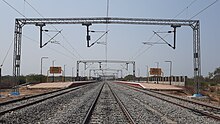
Korutla Railway Station
|
|
| Nickname:
Second Shirdi
|
|

Korutla
Location in Telangana, India
|
|
| Coordinates: 18.8215°N 78.7119°E | |
| Country | |
| State | Telangana |
| District | Jagtial |
| Region | Deccan |
| Government | |
| • Body | Municipality |
| Area | |
| • Total | 34.12 km2 (13.17 sq mi) |
| • Rank | 2 |
| Elevation
[2]
|
287 m (942 ft) |
| Population
(2018)[3]
|
|
| • Total | 89,215 |
| • Density | 2,600/km2 (6,800/sq mi) |
| Languages | |
| • Official | Telugu |
| Time zone | UTC+5:30 (IST) |
| PIN |
505326
|
| Telephone code | 08725 |
| Vehicle registration | TS21 |
| Website | korutlamunicipality |

Geography
Korutla Municipality covers an area of 34.12 square kilometers (13.17 square miles), at an elevation of 287 meters (942 ft).
Demographics
As of 2011 Indian census, Korutla had an estimated population of 66,504 But approximately in 2018 the population is 85,000. The gender split is 50 percent male, 50 percent female. The Literacy rate is 60 percent—approximately equal to the national average of 59.5 percent. Male literacy is 69 percent, and female literacy is 51 percent. 14% of the population is under six years old.
Transportation
It has TSRTC bus stand. The buses travel to Hyderabad, Warangal, Karimnagar, Nizamabad, Tirupati, Pamur , Kanigiri etc. National Highway 63 passes through this town.
Rail
Korutla Railway Station.The Station code is: . It has Railway Connectivity via the Peddapalli–Nizamabad line to Mumbai, Visakhapatnam, Delhi, and Chennai.