
Kyiv
(/kiːv/ KEEV, /ˈkiːjɪv/ KEE-yiv) or Kiev (/ˈkiːɛv/ KEE-ev; Ukrainian: Київ, romanized: Kyiv, pronounced (![]() listen)) is the capital and most populous city of Ukraine. It is in north-central Ukraine along the Dnieper River. As of 1 January 2021, its population was 2,962,180, making Kyiv the seventh-most populous city in Europe.
listen)) is the capital and most populous city of Ukraine. It is in north-central Ukraine along the Dnieper River. As of 1 January 2021, its population was 2,962,180, making Kyiv the seventh-most populous city in Europe.
Kyiv is an important industrial, scientific, educational, and cultural center in Eastern Europe. It is home to many high-tech industries, higher education institutions, and historical landmarks. The city has an extensive system of public transport and infrastructure, including the Kyiv Metro.
The city’s name is said to derive from the name of Kyi, one of its four legendary founders. During its history, Kyiv, one of the oldest cities in Eastern Europe, passed through several stages of prominence and obscurity. The city probably existed as a commercial center as early as the 5th century. A Slavic settlement on the great trade route between Scandinavia and Constantinople, Kyiv was a tributary of the Khazars, until its capture by the Varangians (Vikings) in the mid-9th century. Under Varangian rule, the city became a capital of Kievan Rus’, the first East Slavic state. Completely destroyed during the Mongol invasions in 1240, the city lost most of its influence for the centuries to come. It was a provincial capital of marginal importance in the outskirts of the territories controlled by its powerful neighbours, first Lithuania, then Poland and ultimately Russia.
The city prospered again during the Russian Empire’s Industrial Revolution in the late 19th century. In 1918, after the Ukrainian People’s Republic declared independence from Soviet Russia, Kyiv became its capital. From 1921 onwards, Kyiv was a city of Soviet Ukraine, which was proclaimed by the Red Army, and, from 1934, Kyiv was its capital. The city was almost completely ruined during World War II but quickly recovered in the postwar years, remaining the Soviet Union’s third-largest city.
Following the collapse of the Soviet Union and Ukrainian independence in 1991, Kyiv remained Ukraine’s capital and experienced a steady influx of ethnic Ukrainian migrants from other regions of the country. During the country’s transformation to a market economy and electoral democracy, Kyiv has continued to be Ukraine’s largest and wealthiest city. Its armament-dependent industrial output fell after the Soviet collapse, adversely affecting science and technology, but new sectors of the economy such as services and finance facilitated Kyiv’s growth in salaries and investment, as well as providing continuous funding for the development of housing and urban infrastructure. Kyiv emerged as the most pro-Western region of Ukraine; parties advocating tighter integration with the European Union dominate during elections.
Etymology

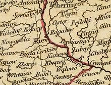
Detail of Sebastian Münster’s Map of Poland and Hungary, 1552, showing Kyiv labelled “Kyouia epatus” (Latin: Kyovia episcopatus, lit. ‘Kyiv episcopate’).
The Ukrainian name is Ки́їв, written in the Ukrainian Cyrillic alphabet, and usually rendered in Latin letters (or romanized) as Kyiv.
Before standardization of the alphabet in the early 20th century, the name was also spelled Кыѣвъ, Киѣвъ, or Кіѣвъ with the now-obsolete letter yat. The Old Ukrainian spelling from the 14th and 15th centuries was nominally *Києвъ, but various attested spellings include кїєва (gen.), Кїєвь and Киев (acc.), кїєво or кїєвом (ins.), києвє, Кіеве, Кїєвѣ, Києвѣ, or Киѣве (loc.).
The name descends from Old East Slavic Kyjevŭ (Kыѥвъ). Old East Slavic chronicles, such as Laurentian Codex and Novgorod Chronicle, used the spellings Києвъ, Къıєвъ, or Кїєвъ. This is most likely derived from the Proto-Slavic name *Kyjevŭ gordŭ (literally, “Kyi’s castle”), and is associated with Kyi (Ukrainian: Кий, Russian: Кий), the legendary eponymous founder of the city.
Kyiv is the romanized official Ukrainian name for the city, and it is used for legislative and official acts. Kiev is the traditional English name for the city, but because of its historical derivation from the Russian name, Kiev became disfavored in many Western media outlets after the outbreak of the Russo-Ukrainian War.
The city was known by various names in history. In the Norse sagas it was Kænugarðr or Kœnugarðr, meaning city of the Kyivans (from Old East Slavic: кияне, romanized: kijane), which survives in modern Icelandic Kænugarður. Perhaps the earliest original manuscript to name the city is the Kyivan letter, written ca. 930 AD by representatives of the city’s Jewish community, with the name written as קייוב׳, Qiyyōḇ.
In the Byzantine Greek of Constantine Porphyrogenitus’s 10th-century De Administrando Imperio it was Κιοάβα, Kioava, Κίοβα, Kiova, and “also called Sambatas”, Σαμβατάς. In Arabic, it was كويابة, Kūyāba in Al-Istakhri’s work of 951 AD, and Zānbat according to ibn Rustah and other 10th-century authors. In the medieval Latin of Thietmar of Merseburg’s Chronicon it was mentioned for the year 1015 as Cuieva. After it was rebuilt in the 15th century, Kyiv was called by the Turkic (Crimean Tatar) name Menkerman or Mankerman.
As a prominent city with a long history, its English name was subject to gradual evolution. Early English sources spelled this word as Kiou, Kiow, Kiew, Kiovia. On one of the oldest English maps of the region, Russiae, Moscoviae et Tartariae published by Ortelius (London, 1570) the name of the city is spelled Kiou. On the 1650 map by Guillaume de Beauplan, the name of the city is Kiiow, and the region was named Kÿowia. In the book Travels, by Joseph Marshall (London, 1772), the city is called Kiovia.
In English, Kiev appeared in print as early as 1804 in John Cary’s “New map of Europe, from the latest authorities”, and in Mary Holderness’s 1823 travelogue New Russia: Journey from Riga to the Crimea by way of Kiev. The Oxford English Dictionary included Kiev in a quotation published by 1883, and Kyiv in 2018.
The Ukrainian version of the name, Kyiw, appears in the Volume 4 of the Geographical Dictionary of the Kingdom of Poland, published in 1883.
A fragment of the New Universal Atlas by John Cary, London, 1808. The city was situated on the borderline between the former Polish (left) and Russian (right) zones of influence, with the name being presented as Kiev.
After Ukraine’s 1991 independence, the Ukrainian government introduced the national rules for transliteration of geographic names into the Latin alphabet for legislative and official acts in October 1995, according to which the Ukrainian name Київ is romanized as Kyiv. These rules are applied for place names and addresses, as well as personal names in passports, street signs, and so on. In 2018, the Ukrainian Foreign Ministry launched #CorrectUA, an online campaign to promote the use of official Ukrainian spellings by countries and organizations, in place of “outdated, Soviet-era” place-names.
The place name Kyiv is standardized in the authoritative database of Ukraine’s toponyms maintained by Ukraine’s mapping agency Derzhheokadastr. It has also been adopted by the United Nations GEGN Geographical Names Database, the United States Board on Geographic Names, the International Air Transport Association, the European Union, English-speaking foreign diplomatic missions and governments, several international organizations, and the Encyclopædia Britannica. Some English-language news sources have adopted Kyiv in their style guides, including the AP, CP, Reuters, and AFP news services, media organizations in Ukraine, and some media organizations in Canada, the United Kingdom, and the United States, despite more resistance to the spelling change compared to others, like Beijing and Mumbai.
Alternative romanizations used in English-language sources include Kyïv, (according to the ALA–LC romanization used in bibliographic cataloguing), Kyjiv (scholarly transliteration used in linguistics), and Kyyiv (the 1965 BGN/PCGN transliteration standard).
The US media organization NPR adopted an on-air pronunciation of Kyiv closer to the Ukrainian, responding to the history and identity of the local population, in January 2022.
History
The first known humans in the region of Kyiv lived there in the late paleolithic period (Stone Age). The population around Kyiv during the Bronze Age formed part of the so-called Trypillian culture, as evidenced by artifacts from that culture found in the area. During the early Iron Age certain tribes settled around Kyiv that practiced land cultivation, husbandry and trading with the Scythians and ancient states of the northern Black Sea coast. Findings of Roman coins of the 2nd to the 4th centuries suggest trade relations with the eastern provinces of the Roman Empire. The people of the Zarubintsy culture are considered the direct ancestors of the ancient Slavs who later established Kyiv. Notable archaeologists of the area around Kyiv include Vikentiy Khvoyka.
Scholars continue to debate when the city was founded: the traditional founding date is 482 AD, so the city celebrated its 1,500th anniversary in 1982. Archaeological data indicates a founding in the sixth or seventh centuries, with some researchers dating the founding as late as the late 9th century,

Legendary Kyi, Shchek, Khoryv and Lybid in the Radziwiłł Chronicle
There are several legendary accounts of the origin of the city. One tells of members of a Slavic tribe (Eastern Polans), brothers Kyi (the eldest, after whom the city was named) Shchek and Khoryv, and their sister Lybid, who founded the city (See the Primary Chronicle). Another legend states that Saint Andrew passed through the area in the 1st century. Where the city is now he erected a cross, where a church later was built. Since the Middle Ages an image of Saint Michael has represented the city as well as the duchy.

Hungarians at Kyiv in 830 during the times of Rus’ Khaganate
There is little historical evidence pertaining to the period when the city was founded. Scattered Slavic settlements existed in the area from the 6th century, but it is unclear whether any of them later developed into the city. On the Ptolemy world map there are several settlements indicated along the mid-stream of Borysthenes, among which is Azagarium, which some historians believe to be the predecessor to Kyiv.
However, according to the 1773 Dictionary of Ancient Geography of Alexander Macbean, that settlement corresponds to the modern city of Chernobyl. Just south of Azagarium, there is another settlement, Amadoca, which is supposed as the capital of Amadoci people living in area between marshes of Amadoca in the west and Amadoca mountains in the east.
Another name for Kyiv mentioned in history, the origin of which is not completely clear, is Sambat, which apparently has something to do with the Khazar Empire. The Primary Chronicle says the residents of Kyiv told Askold “there were three brothers Kyi, Shchek, and Khoriv. They founded this town and died, and now we are staying and paying taxes to their relatives the Khazars”. In his book De Administrando Imperio, Constantine Porphyrogenitus mentions a caravan of small-cargo boats which assembled annually, and writes, “They come down the river Dnieper and assemble at the strong-point of Kyiv (Kioava), also called Sambatas”.
At least three Arabic-speaking 10th century geographers who traveled the area mention the city of Zānbat as the chief city of the Russes. Among them are Ahmad ibn Rustah, Abu Sa’id Gardezi, and an author of the Hudud al-‘Alam. The texts of those authors were discovered by Russian orientalist Alexander Tumansky. The etymology of Sambat has been argued by many historians, including Grigoriy Ilyinsky, Nikolay Karamzin, Jan Potocki, Nikolay Lambin, Joachim Lelewel, Guðbrandur Vigfússon. The historian Julius Brutzkus in his work “The Khazar Origin of Ancient Kiev” hypothesizes that both Sambat and Kyiv are of Khazar origin meaning “hill fortress” and “lower settlement” respectively. Brutzkus claims that Sambat is not Kyiv, but rather Vyshhorod (High City) which is located nearby.
The Primary Chronicles state that at some point during the late 9th or early 10th century Askold and Dir, who may have been of Viking or Varangian descent, ruled in Kyiv. They were murdered by Oleg of Novgorod in 882, but some historians, such as Omeljan Pritsak and Constantine Zuckerman, dispute that, arguing that Khazar rule continued as late as the 920s (among notable historical documents are the Kyivan letter and Schechter Letter).
Other historians suggest that Magyar tribes ruled the city between 840 and 878, before migrating with some Khazar tribes to the Carpathian Basin. The Primary Chronicles also mention movement of Hungarians pass Kyiv. To this day in Kyiv exists a place known as “Uhorske urochyshche” (Hungarian place), which is better known as Askold’s Grave.
According to the aforementioned scholars the building of the fortress of Kyiv was finished in 840 under the leadership of Keő (Keve), Csák, and Geréb, three brothers, possibly members of the Tarján tribe. The three names appear in the Kyiv Chronicle as Kyi, Shchek, and Khoryv and may be not of Slavic origin, as Russian historians have always struggled to account for their meanings and origins. According to Hungarian historian Viktor Padányi, their names were inserted into the Kyiv Chronicle in the 12th century, and they were identified as old-Russian mythological heroes.

The Baptism of Kyivans, a painting by Klavdiy Lebedev
The city of Kyiv stood on the trade route between the Varangians and the Greeks. In 968 the nomadic Pechenegs attacked and then besieged the city. By 1000 AD the city had a population of 45,000.
In March 1169, Grand Prince Andrey Bogolyubsky of Vladimir-Suzdal sacked Kyiv, leaving the old town and the prince’s hall in ruins. He took many pieces of religious artwork – including the Theotokos of Vladimir icon – from nearby Vyshhorod. In 1203, Prince Rurik Rostislavich and his Kipchak allies captured and burned Kyiv. In the 1230s, the city was besieged and ravaged several times by different Rus princes. The city had not recovered from these attacks when, in 1240, the Mongol invasion of Rus’, led by Batu Khan, completed the destruction of Kyiv.
These events had a profound effect on the future of the city and on the East Slavic civilization. Before Bogolyubsky’s pillaging, Kyiv had had a reputation as one of the largest cities in the world, with a population exceeding 100,000 in the beginning of the 12th century.
In the early 1320s, a Lithuanian army led by Grand Duke Gediminas defeated a Slavic army led by Stanislav of Kyiv at the Battle on the Irpen’ River and conquered the city. The Tatars, who also claimed Kyiv, retaliated in 1324–1325, so while Kyiv was ruled by a Lithuanian prince, it had to pay tribute to the Golden Horde. Finally, as a result of the Battle of Blue Waters in 1362, Algirdas, Grand Duke of Lithuania, incorporated Kyiv and surrounding areas into the Grand Duchy of Lithuania. In 1482, Crimean Tatars sacked and burned much of Kyiv.

The 1686 city map of Kyiv (“Kiovia”)
With the 1569 (Union of Lublin), when the Polish–Lithuanian Commonwealth was established, the Lithuanian-controlled lands of the Kyiv region (Podolia, Volhynia, and Podlachia) were transferred from the Grand Duchy of Lithuania to the Crown of the Kingdom of Poland, and Kyiv became the capital of Kyiv Voivodeship. The 1658 Treaty of Hadiach envisaged Kyiv becoming the capital of the Grand Duchy of Rus’ within the Polish–Lithuanian–Ruthenian Commonwealth, but this provision of the treaty never went into operation.
Occupied by Russian troops since the 1654 Treaty of Pereyaslav, Kyiv became a part of the Tsardom of Russia from 1667 on the Truce of Andrusovo and enjoyed a degree of autonomy. None of the Polish-Russian treaties concerning Kyiv have ever been ratified. In the Russian Empire, Kyiv was a primary Christian centre, attracting pilgrims, and the cradle of many of the empire’s most important religious figures, but until the 19th century, the city’s commercial importance remained marginal.

Cossack Bohdan Khmelnytsky entering Kyiv after the Khmelnytsky Uprising against Polish domination. Painting by Mykola Ivasiuk
In 1834, the Russian government established Saint Vladimir University, now called the Taras Shevchenko National University of Kyiv after the Ukrainian poet Taras Shevchenko (1814–1861). (Shevchenko worked as a field researcher and editor for the geography department). The medical faculty of Saint Vladimir University, separated into an independent institution in 1919–1921 during the Soviet period, became the Bogomolets National Medical University in 1995.
During the 18th and 19th centuries, Russian military and ecclesiastical authorities dominated city life; the Russian Orthodox Church had involvement in a significant part of Kyiv’s infrastructure and commercial activity. In the late 1840s the historian, Mykola Kostomarov (Russian: Nikolay Kostomarov), founded a secret political society, the Brotherhood of Saint Cyril and Methodius, whose members put forward the idea of a federation of free Slavic peoples with Ukrainians as a distinct and separate group rather than a subordinate part of the Russian nation; the Russian authorities quickly suppressed the society.
Following the gradual loss of Ukraine’s autonomy, Kyiv experienced growing Russification in the 19th century by means of Russian migration, administrative actions and social modernization. At the beginning of the 20th century the Russian-speaking part of the population dominated the city centre, while the lower classes living on the outskirts retained Ukrainian folk culture to a significant extent. However, enthusiasts among ethnic Ukrainian nobles, military and merchants made recurrent attempts to preserve native culture in Kyiv, by clandestine book-printing, amateur theatre, folk studies etc.

Kyiv in the late 19th century
During the Russian industrial revolution in the late 19th century, Kyiv became an important trade and transportation centre of the Russian Empire, specialising in sugar and grain export by railway and on the Dnieper river. By 1900, the city had also become a significant industrial centre, having a population of 250,000. Landmarks of that period include the railway infrastructure, the foundation of numerous educational and cultural facilities, and notable architectural monuments (mostly merchant-oriented). In 1892, the first electric tram line of the Russian Empire started running in Kyiv (the 3rd in the world).
Kyiv prospered during the late 19th century Industrial Revolution in the Russian Empire, when it became the third most important city of the Empire and the major centre of commerce of its southwest. In the turbulent period following the 1917 Russian Revolution, Kyiv became the capital of several successive Ukrainian states and was caught in the middle of several conflicts: World War I, during which German soldiers occupied it from 2 March 1918 to November 1918, the Russian Civil War of 1917 to 1922, and the Polish–Soviet War of 1919–1921. During the last three months of 1919, Kyiv was intermittently controlled by the White Army. Kyiv changed hands sixteen times from the end of 1918 to August 1920.

Kyiv’s council chambers in 1930
From 1921 to 1991, the city formed part of the Ukrainian Soviet Socialist Republic, which became a founding republic of the Soviet Union in 1922. The major events that took place in Soviet Ukraine during the interwar period all affected Kyiv: the 1920s Ukrainization as well as the migration of the rural Ukrainophone population made the Russophone city Ukrainian-speaking and bolstered the development of Ukrainian cultural life in the city; the Soviet Industrialization that started in the late 1920s turned the city, a former centre of commerce and religion, into a major industrial, technological and scientific centre; the 1932–1933 Great Famine devastated the part of the migrant population not registered for ration cards; and Joseph Stalin’s Great Purge of 1937–1938 almost eliminated the city’s intelligentsia
In 1934, Kyiv became the capital of Soviet Ukraine. The city boomed again during the years of Soviet industrialization as its population grew rapidly and many industrial giants were established, some of which exist today.
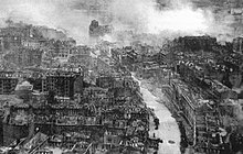
Ruins of Kyiv during World War II
In World War II, the city again suffered significant damage, and Nazi Germany occupied it from 19 September 1941 to 6 November 1943. Axis forces killed or captured more than 600,000 Soviet soldiers in the great encirclement Battle of Kyiv in 1941. Most of those captured never returned alive. Shortly after the Wehrmacht occupied the city, a team of NKVD officers who had remained hidden dynamited most of the buildings on the Khreshchatyk, the main street of the city, where German military and civil authorities had occupied most of the buildings; the buildings burned for days and 25,000 people were left homeless.
Allegedly in response to the actions of the NKVD, the Germans rounded up all the local Jews they could find, nearly 34,000, and massacred them at Babi Yar in Kyiv on 29 and 30 September 1941. In the months that followed, thousands more were taken to Babi Yar where they were shot. It is estimated that the Germans murdered more than 100,000 people of various ethnic groups, mostly civilians, at Babi Yar during World War II.
The Ukrainian national flag was raised outside Kyiv’s City Hall for the first time on 24 July 1990.
Kyiv recovered economically in the post-war years, becoming once again the third-most important city of the Soviet Union. The catastrophic accident at the Chernobyl Nuclear Power Plant in 1986 occurred only 100 km (62 mi) north of the city. However, the prevailing south wind blew most of the radioactive debris away from Kyiv.
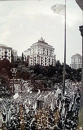
In the course of the collapse of the Soviet Union the Ukrainian parliament proclaimed the Declaration of Independence of Ukraine in the city on 24 August 1991. In 2004–2005, the city played host to the largest post-Soviet public demonstrations up to that time, in support of the Orange Revolution. From November 2013 until February 2014, central Kyiv became the primary location of Euromaidan.
Environment
Geography

A Copernicus Programme Sentinel-2 image of Kyiv and the Dnieper
Geographically, Kyiv is located on the border of the Polesia woodland ecological zone, a part of the European mixed woods area, and the East European forest steppe biome. However, the city’s unique landscape distinguishes it from the surrounding region. Kyiv is completely surrounded by Kyiv Oblast.
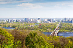
Originally on the west bank, today Kyiv is located on both sides of the Dnieper, which flows southwards through the city towards the Black Sea. The older and higher western part of the city sits on numerous wooded hills (Kyiv Hills), with ravines and small rivers. Kyiv’s geographical relief contributed to its toponyms, such as Podil (means lower), Pechersk (caves), and uzviz (a steep street, “descent”). Kyiv is a part of the larger Dnieper Upland adjoining the western bank of the Dnieper in its mid-flow, and which contributes to the city’s elevation change.
The northern outskirts of the city border the Polesian Lowland. Kyiv expanded into the Dnieper Lowland on the left bank (to the east) as late as the 20th century. The whole portion of Kyiv on the left bank of the Dnieper is generally referred to as Left bank (Ukrainian: Лівий берег, Livyi bereh). Significant areas of the left bank Dnieper valley were artificially sand-deposited, and are protected by dams.
Within the city the Dnieper River forms a branching system of tributaries, isles, and harbors within the city limits. The city is close to the mouth of the Desna River and the Kyiv Reservoir in the north, and the Kaniv Reservoir in the south. Both the Dnieper and Desna rivers are navigable at Kyiv, although regulated by the reservoir shipping locks and limited by winter freeze-over.
In total, there are 448 bodies of open water within the boundaries of Kyiv, which include the Dnieper itself, its reservoirs, and several small rivers, dozens of lakes and artificially created ponds. They occupy 7949 hectares. Additionally, the city has 16 developed beaches (totalling 140 hectares) and 35 near-water recreational areas (covering more than 1,000 hectares). Many are used for pleasure and recreation, although some of the bodies of water are not suitable for swimming.
According to the UN 2011 evaluation, there were no risks of natural disasters in Kyiv and its metropolitan area.
Climate
Kyiv has a warm-summer humid continental climate (Köppen Dfb). The warmest months are June, July, and August, with mean temperatures of 13.8 to 24.8 °C (56.8 to 76.6 °F). The coldest are December, January, and February, with mean temperatures of −4.6 to −1.1 °C (23.7 to 30.0 °F). The highest ever temperature recorded in the city was 39.4 °C (102.9 °F) on 30 July 1936.
The coldest temperature ever recorded in the city was −32.9 °C (−27.2 °F) on 11 January 1951. Snow cover usually lies from mid-November to the end of March, with the frost-free period lasting 180 days on average, but surpassing 200 days in some years.
| hideClimate data for Kyiv (1991–2020, extremes 1881–present) | |||||||||||||
|---|---|---|---|---|---|---|---|---|---|---|---|---|---|
| Month | Jan | Feb | Mar | Apr | May | Jun | Jul | Aug | Sep | Oct | Nov | Dec | Year |
| Record high °C (°F) | 11.1 (52.0) |
17.3 (63.1) |
22.4 (72.3) |
30.2 (86.4) |
33.6 (92.5) |
35.0 (95.0) |
39.4 (102.9) |
39.3 (102.7) |
33.8 (92.8) |
28.0 (82.4) |
23.2 (73.8) |
14.7 (58.5) |
39.4 (102.9) |
| Average high °C (°F) | −0.8 (30.6) |
0.7 (33.3) |
6.5 (43.7) |
15.0 (59.0) |
21.1 (70.0) |
24.6 (76.3) |
26.5 (79.7) |
25.9 (78.6) |
20.0 (68.0) |
12.9 (55.2) |
5.3 (41.5) |
0.5 (32.9) |
13.2 (55.8) |
| Daily mean °C (°F) | −3.2 (26.2) |
−2.3 (27.9) |
2.5 (36.5) |
10.0 (50.0) |
15.8 (60.4) |
19.5 (67.1) |
21.3 (70.3) |
20.5 (68.9) |
14.9 (58.8) |
8.6 (47.5) |
2.6 (36.7) |
−1.8 (28.8) |
9.0 (48.2) |
| Average low °C (°F) | −5.5 (22.1) |
−5.0 (23.0) |
−0.8 (30.6) |
5.7 (42.3) |
10.9 (51.6) |
14.8 (58.6) |
16.7 (62.1) |
15.7 (60.3) |
10.6 (51.1) |
5.1 (41.2) |
0.4 (32.7) |
−3.9 (25.0) |
5.4 (41.7) |
| Record low °C (°F) | −32.9 (−27.2) |
−32.2 (−26.0) |
−24.9 (−12.8) |
−10.4 (13.3) |
−2.4 (27.7) |
2.4 (36.3) |
5.8 (42.4) |
3.3 (37.9) |
−2.9 (26.8) |
−17.8 (0.0) |
−21.9 (−7.4) |
−30.0 (−22.0) |
−32.9 (−27.2) |
| Average precipitation mm (inches) | 38 (1.5) |
40 (1.6) |
40 (1.6) |
42 (1.7) |
65 (2.6) |
73 (2.9) |
68 (2.7) |
56 (2.2) |
57 (2.2) |
46 (1.8) |
46 (1.8) |
47 (1.9) |
618 (24.3) |
| Average extreme snow depth cm (inches) | 9 (3.5) |
11 (4.3) |
7 (2.8) |
0 (0) |
0 (0) |
0 (0) |
0 (0) |
0 (0) |
0 (0) |
0 (0) |
2 (0.8) |
5 (2.0) |
11 (4.3) |
| Average rainy days | 8 | 7 | 9 | 13 | 14 | 15 | 14 | 11 | 14 | 12 | 12 | 9 | 138 |
| Average snowy days | 17 | 17 | 10 | 2 | 0.2 | 0 | 0 | 0 | 0.03 | 2 | 9 | 16 | 73 |
| Average relative humidity (%) | 82.7 | 80.1 | 74.0 | 64.3 | 62.0 | 67.5 | 68.3 | 66.9 | 73.5 | 77.4 | 84.6 | 85.6 | 73.9 |
| Mean monthly sunshine hours | 42 | 64 | 112 | 162 | 257 | 273 | 287 | 252 | 189 | 123 | 51 | 31 | 1,843 |
| Average ultraviolet index | 1 | 1 | 2 | 4 | 6 | 7 | 6 | 6 | 4 | 2 | 1 | 1 | 3 |
| Source 1: Pogoda.ru.net, Central Observatory for Geophysics (extremes), World Meteorological Organization (humidity 1981–2010) | |||||||||||||
| Source 2: Danish Meteorological Institute (sun, 1931–1960) and Weather Atlas | |||||||||||||
Legal status, local government and politics
Legal status and local government
The municipality of the city of Kyiv has a special legal status within Ukraine compared to the other administrative subdivisions of the country. The most significant difference is that the city is considered as a region of Ukraine (see Regions of Ukraine). It is the only city that has double jurisdiction. The Head of City State Administration – the city’s governor – is appointed by the president of Ukraine, while the Head of the City Council – the mayor of Kyiv – is elected by local popular vote.
The mayor of Kyiv is Vitali Klitschko, who was sworn in on 5 June 2014, after he had won the 25 May 2014 Kyiv mayoral elections with almost 57% of the votes. Since 25 June 2014, Klitschko is also Head of Kyiv City Administration. Klitschko was last reelected in the 2020 Kyiv local election with 50.52% of the votes, in the first round of the election.
Most key buildings of the national government are located along Hrushevskoho Street (vulytsia Mykhaila Hrushevskoho) and Institute Street (vulytsia Instytutska). Hrushevskoho Street is named after the Ukrainian academician, politician, historian, and statesman Mykhailo Hrushevskyi, who wrote an academic book titled: “Bar Starostvo: Historical Notes: XV-XVIII” about the history of Bar, Ukraine. That portion of the city is also unofficially known as the government quarter (Ukrainian: урядовий квартал).
The city state administration and council is located in the Kyiv City council building on Khreshchatyk Street. The oblast state administration and council is located in the Kyiv Oblast council building on ploshcha Lesi Ukrayinky (Lesya Ukrayinka Square). The Kyiv-Sviatoshyn Raion state administration is located near Kiltseva doroha (Ring Road) on prospekt Peremohy (Victory Parkway), while the Kyiv-Svyatoshyn Raion local council is located on vulytsia Yantarna (Yantarnaya Street).
-

The seat of the Cabinet of Ministers of Ukraine
-
The presidential administration building
-

The Ministry of Foreign Affairs
-

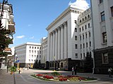
The seat of Kyiv City State and City Council on Khreshchatyk Street
Politics
|
This section needs expansion. You can help by adding to it. (August 2013)
|
The growing political and economic role of the city, combined with its international relations, as well as extensive internet and social network penetration, have made Kyiv the most pro-Western and pro-democracy region of Ukraine; (so called) National Democratic parties advocating tighter integration with the European Union receive most votes during elections in Kyiv. In a poll conducted by the Kyiv International Institute of Sociology in the first half of February 2014, 5.3% of those polled in Kyiv believed “Ukraine and Russia must unite into a single state”, nationwide this percentage was 12.5.
Subdivisions
A view of the left bank neighbourhoods of Kyiv
Traditional subdivision

The Berezniaky neighbourhood in Dnipro Raion
The Dnieper River naturally divides Kyiv into the Right Bank and the Left Bank areas. Historically located on the western right bank of the river, the city expanded into the left bank only in the 20th century. Most of Kyiv’s attractions as well as the majority of business and governmental institutions are located on the right bank. The eastern “Left Bank” is predominantly residential. There are large industrial and green areas in both the Right Bank and the Left Bank.
Kyiv is further informally divided into historical or territorial neighbourhoods, each housing from about 5,000 to 100,000 inhabitants.

Formal subdivision
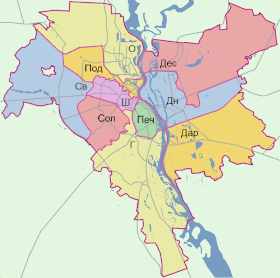
The ten raions (districts) of Kyiv:
- Г — Holosiiv Raion
- О — Obolon Raion
- Печ — Pechersk Raion
- Под — Podil Raion
- Ш — Shevchenko Raion
- Св — Sviatoshyn Raion
- Сол — Solomianka Raion
- Дар — Darnytsia Raion
- Дес — Desna Raion
- Дн — Dnipro Raion
The first known formal subdivision of Kyiv dates to 1810 when the city was subdivided into 4 parts: Pechersk, Starokyiv, and the first and the second parts of Podil. In 1833–1834 according to Tsar Nicholas I’s decree, Kyiv was subdivided into 6 police raions (districts); later being increased to 10. In 1917, there were 8 Raion Councils (Duma), which were reorganised by bolsheviks into 6 Party-Territory Raions.
During the Soviet era, as the city was expanding, the number of raions also gradually increased. These newer districts of the city, along with some older areas were then named in honour of prominent communists and socialist-revolutionary figures; however, due to the way in which many communist party members eventually, after a certain period of time, fell out of favour and so were replaced with new, fresher minds, so too did the names of Kyiv’s districts change accordingly.
The last raion reform took place in 2001 when the number of raions has been decreased from 14 to 10.
Under Oleksandr Omelchenko (mayor from 1999 to 2006), there were further plans for the merger of some raions and revision of their boundaries, and the total number of raions had been planned to be decreased from 10 to 7. With the election of the new mayor-elect (Leonid Chernovetsky) in 2006, these plans were shelved.
Each raion has its own locally elected council with jurisdiction over a limited scope of affairs.
Demographics
According to the official registration statistics, there were 2,847,200 residents within the city limits of Kyiv in July 2013.
Historical population
According to the All-Ukrainian Census, the population of Kyiv in 2001 was 2,611,300. The historic changes in population are shown in the side table. According to the census, some 1,393,000 (53.3%) were female and 1,219,000 (46.7%) were male. Comparing the results with the previous census (1989) shows the trend of population ageing which, while prevalent throughout the country, is partly offset in Kyiv by the inflow of working age migrants. Some 1,069,700 people had higher or completed secondary education, a significant increase of 21.7% since 1989.
The June 2007 unofficial population estimate based on amount of bakery products sold in the city (thus including temporary visitors and commuters) gave a number of at least 3.5 million people.
Ethnic composition
According to the 2001 census data, more than 130 nationalities and ethnic groups reside within the territory of Kyiv. Ukrainians constitute the largest ethnic group in Kyiv, and they account for 2,110,800 people, or 82.2% of the population. Russians comprise 337,300 (13.1%), Jews 17,900 (0.7%), Belarusians 16,500 (0.6%), Poles 6,900 (0.3%), Armenians 4,900 (0.2%), Azerbaijanis 2,600 (0.1%), Tatars 2,500 (0.1%), Georgians 2,400 (0.1%), Moldovans 1,900 (0.1%).
A 2015 study by the International Republican Institute found that 94% of Kyiv was ethnic Ukrainian, and 5% ethnic Russian. Most of the city’s non-Slav population comprises Tatars, Caucasians and other people from the former Soviet Union.
Language statistics
Both Ukrainian and Russian are commonly spoken in the city; approximately 75% of Kyiv’s population responded “Ukrainian” to the 2001 census question on their native language, roughly 25% responded “Russian”. According to a 2006 survey, Ukrainian is used at home by 23% of Kyivans, 52% use Russian, and 24% switch between both. In the 2003 sociological survey, when the question “What language do you use in everyday life?” was asked, 52% said “mostly Russian”, 32% “both Russian and Ukrainian in equal measure”, 14% “mostly Ukrainian”, and 4.3% “exclusively Ukrainian”.
According to the census of 1897, of Kyiv’s approximately 240,000 people approximately 56% of the population spoke the Russian language, 23% spoke the Ukrainian language, 13% spoke Yiddish, 7% spoke Polish and 1% spoke the Belarusian language.
A 2015 study by the International Republican Institute found that the languages spoken at home in Kyiv were Ukrainian (27%), Russian (32%), and an equal combination of Ukrainian and Russian (40%).
Jews
The Jews of Kyiv are first mentioned in a 10th century letter. The Jewish population remained relatively small until the nineteenth century. A series of pogroms was carried out in 1882, and another in 1905. On the eve of World War I, the city’s Jewish population was over 81,000. In 1939 there were approximately 224,000 Jews in Kyiv, some of whom fled the city ahead of the German invasion of the Soviet Union that began in June 1941. On 29 and 30 September 1941, nearly 34,000 Kyivan Jews were massacred at Babi Yar by the German Wehrmacht, SS, Ukrainian Auxiliary Police, and local collaborators.
Jews began returning to Kyiv at the end of the war, but experienced another pogrom in September 1945. In the 21st century, Kyiv’s Jewish community numbers about 20,000. There are two major synagogues in the city: the Great Choral Synagogue and the Brodsky Choral Synagogue.
Cityscape

Modern Kyiv is a mix of the old (Kyiv preserved about 70 percent of more than 1,000 buildings built during 1907–1914) and the new, seen in everything from the architecture to the stores and to the people themselves. When the capital of the Ukrainian SSR was moved from Kharkiv to Kyiv many new buildings were commissioned to give the city “the gloss and polish of a capital”. In the discussions that centered on how to create a showcase city center, the current city center of Khreshchatyk and Maidan Nezalezhnosti (Independence Square) were not the obvious choices. Some of the early, ultimately not materialised, ideas included a part of Pechersk, Lypky, European Square and Mykhailivska Square.
The plans of building massive monuments (of Vladimir Lenin and Joseph Stalin) were also abandoned, due to lack of money (in the 1930s–1950s) and because of Kyiv’s hilly landscape. Experiencing rapid population growth between the 1970s and the mid-1990s, the city has continued its consistent growth after the turn of the millennium. As a result, Kyiv’s central districts provide a dotted contrast of new, modern buildings among the pale yellows, blues and greys of older apartments. Urban sprawl has gradually reduced, while population densities of suburbs has increased. The most expensive properties are located in the Pechersk, and Khreshchatyk areas. It is also prestigious to own a property in newly constructed buildings in the Kharkivskyi Raion or Obolon along the Dnieper.
Ukrainian independence at the turn of the millennium has heralded other changes. Western-style residential complexes, modern nightclubs, classy restaurants and prestigious hotels opened in the centre. And most importantly, with the easing of the visa rules in 2005, Ukraine is positioning itself as a prime tourist attraction, with Kyiv, among the other large cities, looking to profit from new opportunities. The centre of Kyiv has been cleaned up and buildings have been restored and redecorated, especially Khreshchatyk and Maidan Nezalezhnosti. Many historic areas of Kyiv, such as Andriyivskyy Descent, have become popular street vendor locations, where one can find traditional Ukrainian art, religious items, books, game sets (most commonly chess) as well as jewellery for sale.
At the United Nations Climate Change Conference 2009, Kyiv was the only Commonwealth of Independent States city to have been inscribed into the TOP30 European Green City Index (placed 30th).
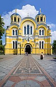
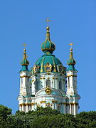
Kyiv’s most famous historical architecture complexes are the St. Sophia Cathedral and the Kyiv Pechersk Lavra (Monastery of the Caves), which are recognized by UNESCO as a World Heritage Site. Noteworthy historical architectural landmarks also include the Mariinskyi Palace (designed and constructed from 1745 to 1752, then reconstructed in 1870), several Eastern Orthodox churches such as St. Michael’s Cathedral, St. Andrew’s, St. Vladimir’s, the reconstructed Golden Gate and others.
One of Kyiv’s widely recognized modern landmarks is the highly visible giant Mother Motherland statue made of titanium standing at the National Museum of the History of Ukraine in the Second World War on the Right bank of the Dnieper River. Other notable sites is the cylindrical Salut hotel, located across from Glory Square and the eternal flame at the World War Two memorial Tomb of the Unknown Soldier, and the House with Chimaeras.
Among Kyiv’s best-known monuments are Mikhail Mikeshin’s statue of Bohdan Khmelnytsky astride his horse located near St. Sophia Cathedral, the venerated Vladimir the Great (St. Vladimir), the baptizer of Rus’, overlooking the river above Podil from Saint Vladimir Hill, the monument to Kyi, Shchek and Khoryv and Lybid, the legendary founders of the city located at the Dnieper embankment. On Independence Square in the city centre, two monuments elevate two of the city protectors; the historic protector of Kyiv Michael Archangel atop a reconstruction of one of the old city’s gates and a modern invention, the goddess-protector Berehynia atop a tall column.
- Architecture and historically significant sites and monuments in Kyiv
-

Golden Gate
-

Holy Dormition Cathedral
-

St. Sophia Cathedral
-
St. Volodymyr’s Cathedral
-

St. Michael’s Golden-Domed Monastery
-

Intercession Convent
-

St. Nicholas Roman Catholic Cathedral
-
Saint Andrew’s Church
-

Mariinskyi Palace
-

National Bank of Ukraine
-

House with Chimaeras
-

Brodsky Choral Synagogue – Moorish Revival architecture
Culture
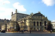
The Kyiv National Opera House