
North 24 Parganas
(abv. 24 PGS (N)) or sometimes North Twenty Four Parganas is a district in southern West Bengal, of eastern India. North 24 Parganas extends in the tropical zone from latitude 22° 11′ 6″ north to 23° 15′ 2″ north and from longitude 88º20′ east to 89º5′ east. It is bordered to Nadia by north, to Bangladesh (Khulna Division) by north and east, to South 24 Parganas and Kolkata by south and to Kolkata, Howrah and Hoogly by west. Barasat is the district headquarters of North 24 Parganas. North 24 Parganas is West Bengal’s most populous district and also (since 2014) the most populated district in the whole of India. It is the tenth-largest district in the State by area.
History
| Year | Pop. | ±% p.a. |
|---|---|---|
| 1901 | 1,016,001 | — |
| 1911 | 1,166,158 | +1.39% |
| 1921 | 1,239,719 | +0.61% |
| 1931 | 1,357,831 | +0.91% |
| 1941 | 1,711,806 | +2.34% |
| 1951 | 2,114,097 | +2.13% |
| 1961 | 3,127,685 | +3.99% |
| 1971 | 4,207,420 | +3.01% |
| 1981 | 5,529,497 | +2.77% |
| 1991 | 7,281,881 | +2.79% |
| 2001 | 8,934,286 | +2.07% |
| 2011 | 10,009,781 | +1.14% |
| source: | ||
Ancient history
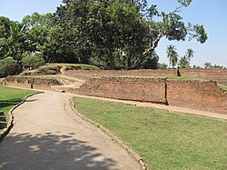
The Baraha-mihir or Khana-mihir mound at Berachampa. It was first excavated in 1956–57 revealing a continuous sequence of cultural remains from 11th century BC pre-Mouryan period to 12th century AD Pala period.
According to Ptolemy’s Geography, written in the second century A.D., the ancient land of Gangaridi was stretched between the rivers Bhagirathi-Hoogly (lower Ganges) and Padma-Meghna. The modern-day 24 Parganas was the southern and the south-eastern territory of that legendary kingdom.
Archaeological excavation at Berachampa village in Deganga PS proves that though the area was not directly attached to the rule of the Guptas, yet it could not shun their cultural influence. Xuanzang (c. 629–685) visited 30 Buddhist Biharas and 100 Hindu Temples in India and some of these were in the Greater 24 Parganas region.
The district was not a part of Shashanka’s unified Bengali empire known as Gauda, but it is assumed that the district which was the south-west frontier territory of ancient Bengal, was comprised in under the rule of Dharmapala (estimated c. 770–810). The Pala rule was not quite strong in this part, as no excavation uncovered any of Buddhist Pala antiquities but many Hindu Sena sculptures.
Middle Ages
In the middle of the 16th century, Portuguese pirates began to invade and plunder many of the waterways and prosperous human settlements in the lower delta region. People left these places out of the fear of being murdered, raped, or captured to be sold as slaves. The Basirhat sub-division of North 24 Parganas suffered most from these torments.
Shrihari (Shridhar), a Kayastha, was an influential officer in the service of Daud Khan Karrani. On the fall of Daud he fled away with the government treasure in his custody. He then set up a kingdom for himself in the marshy land to the extreme south of Khulna district (1574) and assumed the title of Maharaja. Pratapaditya succeeded to the kingship in 1574. The baharistan and the travel diary of Abdul Latif and the contemporary European writers, all testify to the personal ability of Pratapaditya, his political pre-eminence, material resources. His territories covered the greater part of what is now included in the greater Jessore, Khulna and Barisal districts. He established his capital at Dhumghat, a strategic position at the confluence of the Jamuna and Ichhamati before it was shifted to Ishwaripur.
Maharaja Pratapaditya, soon became one of the 12 feudal lords of Bengal who not only declared their sovereignty from the Mughal Empire in the ruling of Jessore, Khulna, Barisal and Greater 24 Parganas, but also fought and resisted the Portuguese in the early years of the 17th century. When he was finally defeated by the Mughals. Pratapaditya lost both the battles of Salka and Magrahat. His fate was sealed and he was compelled to tender submission to Islam Khan at Dhaka. His kingdom was annexed. He probably died at Benares on his way to Delhi from Dhaka, as a prisoner of war to the Mughals.
After his death, Bhavanand Majumdar, who had been in the service of Pratapaditya, was given the throne by Raja Man Singh, and he later became the founder of the Nadiya Raj family. Laksmikanta Gangopadhyay better known as Laksmikanta Roy Choudhury, the well known Brahmin scholar who was the son of great saint Kamdev Brahmachari and also a close associate of Raja Basanta Ray, was given tax free jaigir of eight parganas, including the areas in and around Kalikatah as Gurudakshina by Raja Man Singh in 1608.
Jashoreshwari Kali Temple (built by Pratapaditya), Chanda Bhairab Mandir at Ishwaripur (built during the Sena period), Five domed Tenga Mosque at Banshipur (Mughal period), two big and four small domed Hammankhana (constructed by Pratapaditya) at Bangshipur, Govinda Dev Temple at Gopalpur (built by Basanta Roy, uncle of Maharaja Pratapaditya in 1593), Jahajghata Port (Khanpur), Kalighat Temple (owned by Laksmikanta Roy Choudhury) bear archaeological evidences of the Bhuiyan and Majumdar kings.
British Raj
The territory of Greater 24 Parganas were under the Satgaon (ancient Saptagram, now in Hoogly district) administration during the Mughal era and later it was included in Hoogly chakla (district under post-Mughal Nawabi rule) during the rule of Murshid Quli Khan. In 1757, after the Battle of Plassey, Nawab Mir Jafar conferred the Zamindari of 24 parganas and janglimahals (small administrative units) upon the British East India Company. These Parganas are 1.Akbarpur, 2.Amirpur 3.Asimabad 4.Balia 5.Baridhati 6.Basandhari 7.Calcutta 8.Dakshin Sagar 9.Garh 10.Hathiagarh 11.Ikhtiarpur 12.Kharijuri 13.Khaspur 14.Maidanmal or Mednimall 15.Magura 16. Mayda 17.Manpur 18.Murnagacha 19.Paikan 20.Pechakuli 21.Satal 22.Shahnagar 23.Shahpur and 24. Uttar Pargana (O’Mally, L.S.S. (1914) Bengal District Gazetteers: 24 Parganas. Page 44). . Since then, this entire territory is known as Twentyfour Parganas.
In 1751, the Company assigned John Zephaniah Holwell as zemindar of the District. In 1759, after the Bengali War of 1756–1757, the Company assigned it to Lord Clive as a personal Jaghir (zamindari) and after his death it again came under the direct authority of the company.
In 1793, during the rule of Lord Cornwallis, entire Sunderbans were in Twentyfour Parganas. In 1802, some parganas on the western banks of river Hoogly were included into it. These parganas were in Nadia earlier. In 1814, a separate collectorate was established in Twenty-four Parganas. In 1817, Falta and Baranagar and in 1820, some portions of Nadia’s Balanda and Anwarpur were encompassed to it. In 1824, portions of Barasat, Khulna and Bakhargunge (now in Bangladesh) were also included to it. In 1824, the district headquarters was shifted from Kolkata to Baruipur, but in 1828, it was removed to Alipore. In 1834, the district was split into two districts – Alipore and Barasat, but later these were united again.
In 1905, some portion of this district around the Sunderbans was detached and linked to Khulna and Barishal. These parts remained in Bangladesh territories where Jessore’s Bangaon was joined to Twentyfour Pargana after the 1947 partition.
After Independence
In 1980, an administrative reform committee under the chairmanship of Dr. Ashok Mitra suggested to split the district into two and as per the recommendation of the committee in 1983, 1 March two districts – North 24 Parganas (24 PGS (N)) and South 24 Parganas (24 PGS (S)) were created. The North 24 Parganas which was included to the Presidency Division has been formed with five sub-divisions of the Greater 24 Parganas, namely Barasat Sadar (Headquarters), Barrackpore, Basirhat, Bangaon, and Bidhannagar (a satellite township of Kolkata, popularly known as Salt Lake).
Geography
The district lies within the Ganga–Brahmaputra delta. The major distributory of river Ganga that is river Hooghly flows along the western border of the district. There are many other distributory branches, sub-branches of Ganga river and other local rivers, which include the Ichhamati, Jamuna, and Bidyadhari.
Land
The type of soil varies widely from alluvial to clay loam.
Groundwater arsenic contamination
North 24 Parganas is one of the nine severely arsenic affected districts in West Bengal. On the basis of updated survey conducted by School of Environmental Studies (SOES), Jadavpur University, out of total 22 administrative blocks in 22, 21 and 16 blocks arsenic above the 10 μg/L (WHO Recommended value of arsenic in drinking water), 50 μg/L (Indian standard value of arsenic in drinking water) and 300 μg/L (the concentration predicting overt arsenical skin lesions) was noted respectively.
The maximum arsenic contamination level found in this district is 2830 μg/L in the Baduria block.
Climate
The climate is tropical, like the rest of the Gangetic West Bengal. It is also characterised by the Monsoon, which lasts from early June to mid September sometimes in October. The weather remains dry during the winter (late November to mid February) and too humid during summer.
Temperature ranges from 41 °C in May and 10 °C in January while relative humidity ranges between 50% in March & 90% in July. The average annual rainfall is 1,579mm.
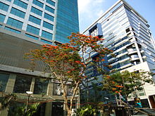
Economy
Omega and Infinity Benchmark, office buildings in Salt Lake, Kolkata

The Bengal Intelligent Park in Sector V.

The Cognizant Technology Solutions office in Sector V.
People are mainly engaged in farming, fishing and other agricultural activities. The average size of agricultural landholdings is about 3.2 Bighas. North 24 Parganas is one of the less economically backward districts of West Bengal, but there is chronic poverty in the southern half of the District (the Sundarbans area)
The information technology hub of Kolkata is at this district, which is the centre of some of the notable IT/ITES Indian and multinational companies. Approximately 1,500 companies have their offices in Sector V. Majority of the corporate offices are situated in Sector V and Sector III. Around 3.5 Lakh (by 2017) people are employed in Salt Lake City.
Divisions
Administrative subdivisions
The district comprises five subdivisions: Barrackpore, Barasat Sadar, Basirhat, Bangaon and Bidhannagar.
- Barrackpore Subdivision consists of 16 municipalities (Kanchrapara, Halisahar, Naihati, Bhatpara, Garulia, Barrackpore, North Barrackpur, New Barrackpur, Titagarh, Khardaha, Panihati, Kamarhati, Baranagar, Dum Dum, North Dumdum and South Dumdum) and 2 community development blocks: Barrackpore I and Barrackpore II.
- Barasat Sadar Subdivision consists of six municipalities (Barasat, Habra, Ashoknagar Kalyangarh, Madhyamgram, New Barrackpore and Gobardanga) and 7 community development blocks: Barasat I, Barasat II, Amdanga, Deganga, Habra I, Habra II and Rajarhat (now shifted to Bidhannagar Subdivision).
- Bongaon Subdivision, consists of Bangaon municipality (Thakurnagar) and three community development blocks: Bagdah, Bangaon and Gaighata.
- Basirhat Subdivision consists of three municipalities (Basirhat, Baduria and Taki) and ten community development blocks: Baduria, Basirhat I, Basirhat II, Haroa, Hasnabad, Hingalganj, Minakhan, Sandeshkhali I, Sandeshkhali II, Swarupnagar.
- Bidhannagar Subdivision consists of Bidhannagar Municipal Corporation and one community development blocks Rajarhat.
Barasat is the district headquarters. There are 35 police stations, 22 development blocks, 27 municipalities, 200 gram panchayats and 1599 villages in this district.
Other than municipality area, each subdivision contains community development blocks which in turn are divided into rural areas and census towns. In total there are 48 urban units: 27 municipalities and 20 census towns and 1 cantonment board.
Barrackpore subdivision
- 16 municipalities: Kanchrapara, Halisahar, Naihati, Bhatpara, Garulia, Barrackpore, North Barrackpur, New Barrackpur, Titagarh, Khardaha, Panihati, Kamarhati, Baranagar, Dum Dum, North Dumdum and South Dumdum.
- One Cantonment Board: Barrackpur Cantonment.
- One more census town: Ichhapur Defence Estate.
- Barrackpore I (Community development block) consists of rural areas with 8 gram panchayats and three census towns: Jetia, Garshyamnagar and Kaugachhi.
- Barrackpore II (Community development block) consists of rural areas with 6 gram panchayats and six census towns: Jafarpur, Talbandha, Muragachha, Patulia, Ruiya and Chandpur.
- Panchayet: Duttapukur
Barasat Sadar subdivision
- 6 municipalities: Barasat, Habra, Ashoknagar Kalyangarh, Madhyamgram and Gobardanga.
- Barasat I (Community development block) consists of rural areas with 9 gram panchayats and 1 census town: Duttapukur.
- Barasat II (Community development block) consists of rural areas only with 7 gram panchayats.
- Amdanga (Community development block) consists of rural areas only with 8 gram panchayats.
- Deganga (Community development block) consists of rural areas only with 13 gram panchayats.
- Habra I (Community development block) consists of rural areas with 7 gram panchayats and 3 census towns: Nokpul, Maslandapur and Sadpur.
- Habra II (Community development block) consists of rural areas with 8 gram panchayats and 2 census towns: Bara Bamonia and Guma.
- Rajarhat (Community development block) (now shifted to Bidhannagar Subdivision) consists of rural areas with 6 gram panchayats (after Mahishbathan II gram panchayat being shifted to Bidhannagar Municipal Corporation, number of gram panchayats becomes 5) and 1 census town: Raigachhi.
Bangaon subdivision
- 1 municipality: Bangaon.
- Bagdah (Community development block) consists of rural areas only with 9 gram panchayats.
- Bangaon (Community development block) consists of rural areas only with 16 gram panchayats.
- Gaighata (Community development block) consists of rural areas with 13 gram panchayats and seven census towns: Chandpara(7,113), Chhekati (4,995), Sonatikiri (6,919), Dhakuria (10,165), Chikanpara (9,594), Shimulpur (20,803) and Bara (5,172).
Basirhat subdivision
- Three municipalities: Basirhat, Baduria and Taki.
- Baduria (Community development block) consists of rural areas only with 14 gram panchayats.
- Basirhat I (Community development block) consists of rural areas only with 7 gram panchayats.
- Basirhat II (Community development block) consists of rural areas with 9 gram panchayats and one census town: Dhanyakuria.
- Haroa (Community development block) consists of rural areas only with 8 gram panchayats.
- Hasnabad (Community development block) consists of rural areas only with 9 gram panchayats.
- Hingalganj (Community development block) consists of rural areas only with 9 gram panchayats.
- Minakhan (Community development block) consists of rural areas only with 8 gram panchayats.
- Sandeshkhali I (Community development block) consists of rural areas only with 8 gram panchayats.
- Sandeshkhali II (Community development block) consists of rural areas only with 8 gram panchayats.
- Swarupnagar (Community development block) consists of rural areas only with 10 gram panchayats.
Bidhannagar subdivision
This subdivision consists of the Bidhannagar Municipal Corporation.
- Rajarhat (Community development block) is also shifted to this subdivision now.
Assembly constituencies
As per order of the Delimitation Commission in respect of the delimitation of constituencies in the West Bengal, the district is divided into 33 assembly constituencies:
| Sl. No. | Assembly Name | Reservation | Constituency no. |
|---|---|---|---|
| 1 | Bagdah | SC | 94 |
| 2 | Bangaon Uttar | SC | 95 |
| 3 | Bangaon Dakshin | SC | 96 |
| 4 | Gaighata | SC | 97 |
| 5 | Swarupnagar | SC | 98 |
| 6 | Baduria | N/A | 99 |
| 7 | Habra | N/A | 100 |
| 8 | Ashoknagar | N/A | 101 |
| 9 | Amdanga | N/A | 102 |
| 10 | Bijpur | N/A | 103 |
| 11 | Naihati | N/A | 104 |
| 12 | Bhatpara | N/A | 105 |
| 13 | Jagatdal | N/A | 106 |
| 14 | Noapara | N/A | 107 |
| 15 | Barrackpore | N/A | 108 |
| 16 | Khardah | N/A | 109 |
| 17 | Dum Dum Uttar | N/A | 110 |
| 18 | Panihati | N/A | 111 |
| 19 | Kamarhati | N/A | 112 |
| 20 | Baranagar | N/A | 113 |
| 21 | Dum Dum | N/A | 114 |
| 22 | Rajarhat-New Town | SC | 115 |
| 23 | Bidhannagar | N/A | 116 |
| 24 | Rajarhat Gopalpur | N/A | 117 |
| 25 | Madhyamgram | N/A | 118 |
| 26 | Barasat | N/A | 119 |
| 27 | Deganga | N/A | 120 |
| 28 | Haroa (SC) | SC | 121 |
| 29 | Minakhan | SC | 122 |
| 30 | Sandeshkhali | ST | 123 |
| 31 | Basirhat Uttar | N/A | 124 |
| 32 | Basirhat Dakshin | N/A | 125 |
| 33 | Hingalganj | SC | 126 |
- Bagdah, Bangaon Uttar and Dakshin, Gaighata, Swarupnagar, Rajarhat-New Town, Haroa, Minakhan and Hingalganj constituencies are reserved for Scheduled Castes (SC) candidates while Sandeshkhali is reserved for Schedule Tribe (ST).
- Bagdaha, Bangaon Uttar and Dakshin, Gaighata, Swarupnagar, and Kalyani and Haringhata (two assembly constituencies from Nadia) assembly constituencies form the Bangaon (Lok Sabha constituency) which is reserved for Schedule Caste (SC) candidate.
- Habra, Ashoknagar, Rajarhat-New Town, Bidhannagar, Madhyagram, Barasat, Deganga assembly constituencies form the Barasat (Lok Sabha constituency).
- Khardaha, Dum Dum, Dum Dum Uttar, Panihati, Kamarhati, Baranagar, Rajarhat Gopalpur assembly constituencies form the Dum Dum (Lok Sabha constituency).
- Amdanga, Bijpur, Naihati, Bhatpara, Jagatdal, Noapara, Barrackpore assembly constituencies form the Barrackpore (Lok Sabha constituency).
- Baduria, Haroa, Minakhan, Sandeshkhali, Basirhat Uttar, Basirhat Dakshin, Hingalganj constituencies are part of the Basirhat (Lok Sabha constituency), which also contains one assembly segment from South 24 Parganas district.
Education
Universities
- Indian Statistical Institute
- Maulana Abul Kalam Azad University of Technology
- West Bengal State University
- JIS University
- Techno India University
- Brainware University
- Adamas University
- University of Calcutta (Technological Campus)
- Jadavpur University (Second Campus)
- Aliah University
- Netaji Subhas Open University
- Amity University
- Sister Nivedita University
- St. Xavier’s University, Kolkata
- Adamas University, Barasat, Kolkata
-

Indian Statistical Institute, Baranagar
-
West Bengal State University, located at Barasat, the main general degree university of the district
Colleges
- Techno Engineering college Banipur
- Acharya Prafulla Chandra College
- Amdanga jugal kishore mahavidyalaya
- Narula Institute of Technology
- Basirhat College
- College of Medicine & Sagore Dutta Hospital
- Guru Nanak Institute of Dental Sciences and Research
- Guru Nanak Institute of Technology
- Bhairab Ganguly College
- Bidhannagar College
- Ramakrishna Mission Vivekananda Centenary College
- Barasat Government College
- Barasat College
- Barrackpore Rastraguru Surendranath College
- Government College of Engineering and Leather Technology
- Gobardanga Hindu College
- Dinabandhu Mahavidyalay
- Dr. B. R. Ambedkar Satabarsiki Mahavidyalaya, Helencha
- Sree Chaitanya College
- Institute of Engineering and Management
- Taki Government College
- Rishi Bankim Chandra College, Naihati
Kanchrapara College
- Amdanga jugal kishore mahavidyalata
- Vivekananda College, Madhyamgram
Schools

Baranagar RKM School
• Sodepur High School
- Hatthuba Adarsha Vidyapith(H.S)
- Habra High School (H.S)
- Prafullanagar Vidyamandir (H.S)
- Ashokenagar Boys Secondary School
- Kamini Kumar Girls’ High School
- Ashokenagar Banipith Girls’ High School
- St. Stephen’s School
- St. Xavier’s Institution (Panihati)
- Adamas International School
- Stratford Day School
- Aditya Academy (Senior Secondary)
- Auxilium Convent School
- Kendriya Vidyalaya Ordnance Factory, Dum Dum
- Baranagore Ramakrishna Mission Ashrama High School
- Barrackpore Government High School
- Berachampa Deulia Uchcha Vidyalaya
- Kartikpur Deganga Adarsha Vidyapith
- Deganga Kartickpur Adarsha Balika Vidyapith
- Doon International School, Basirhat
- Kendriya Vidyalaya Barrackpore (Army)
- Rahara Ramakrishna Mission Boys’ Home High School
- Pancha Gram High School,Amboula
- Morning Bells Academy
- Banamalipur Priyanath Institution
- Purba Barasat Adarsha Bidyapeeth
- Kajal Memorial Day School
- Malangapara K.C.B Institution
- Kanchrapara Indian Girls’ High School
- Kanchrapara Harnett High School
- Kanti chandra High school
- Sukantanagar Vidyaniketan
- Bira ballav para high school
- Bishnupur Sir Romesh Institution
- Nabapalli Jogendranath Balika Vidyamandir
Culture
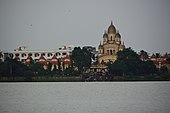
Dakshineswar Kali Temple

Durga idol at a pandel in Baranagar
This district is rich in culture. Many famous places like Dakshineswar Kali Temple, Baranagar Math (first monastery of Ramakrishna Order) are situated in this district. Many places of this district are famous for festivals – Habra, Barasat, Naihati and Madhyamgram are for Kali puja, Bangaon, Baranagar, Basirhat are for Durga puja, Ashoknagar Kalyangarh is for Jagatdhatri puja, Berachampa is for Basanti puja etc.
Transport
Railways
The electrified suburban rail network of the ER is extensive and penetrates far and deep into the neighbouring districts of Kolkata, South 24 Parganas, Nadia, Howrah, Hooghly etc.
The Circular Rail encircles the entire city of Kolkata, and also used to provide an offshoot to connect the Dum Dum Airport, but now it is limited up to Dum Dum Cantonment. Jessore Road and Biman Bandar railway stations are closed for the construction work of Noapara–Dum Dum Airport–Barasat Metro rail (Kolkata Metro Line 4).
Metro rail is also a transport medium of this district’s people. Four stations of Kolkata Metro Line 1 are located here, Dum Dum metro station at Dum Dum, Baranagar metro station at Baranagar, Dakshineswar metro station at Dakshineswar and Noapara metro station at Noapara, Baranagar.
-
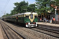
Kolkata Suburban EMU Train
-
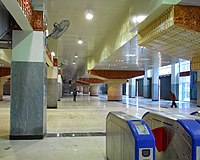
Kolkata Metro’s largest station Noapara metro station at Noapara, Baranagar
Airports
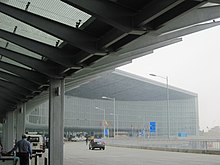
Cityside view of the new Integrated Terminal of Netaji Subhash Chandra Bose International Airport
The Netaji Subhash Chandra Bose International Airport (IATA code:CCU), which is at Dum Dum (previously known as Dum Dum Airport) in North 24 Parganas, is the only airport serving the city Kolkata. It operates both domestic and international flights. It is a gateway to North-East India, Bangkok, and Bangladesh. The number of people using the airport has consistently increased over the last few years.
Roadways
The road network is fairly well developed. Sparsed across by state-highways, it provides a convenient means of transport. NH 12 connects the district with northern and southern region of the state and its sub road NH 112 connect the district headquarter Barasat with the border town Bangaon and Petrapole, the largest land port of India.
Demographics
According to the 2011 census North 24 Parganas district has a population of 10,009,781, roughly equal to the nation of Bolivia or the US state of Michigan. This gave it a ranking of second in India (out of a total of 640) and first in its state. However, in 2014 the Thane district (in Maharashtra), which had been ranked first in India in 2011, was divided into two, thus promoting North 24 Parganas District to first in India. The district has a population density of 2,463 inhabitants per square kilometre (6,380/sq mi). Its population growth rate over the decade 2001–2011 was 12.86%. North Twenty Four Parganas has a sex ratio of 949 females for every 1000 males, and a literacy rate of 84.95%. Scheduled Castes and Scheduled Tribes make up 21.67% and 2.64% of the population respectively.
- Population Density: 2959 per square km
- Sex ratio: 982 females per 1000 males
- Growth Rate (1991–2000): 24.64% (approximately 2.5% per annum)
- Literacy rate (excluding 0–6 age group), in percentage: 87.66 (highest in West Bengal).
- Male: 93.14; Female: 81.81
Languages of North 24 Parganas district (2011)
According to the 2011 census, 88.91% of the population spoke Bengali, 7.69% Hindi and 2.28% Urdu as their first language.
Flora and fauna
The district is also home to the Bibhutibhushan Wildlife Sanctuary, which was established in 1985 and has an area of 0.6 km2 (0.2 sq mi).
Health facilities
- District Hospitals: 10 with 2500 beds
- Sub Divisional Hospitals: 14 with 1870 beds
- State General Hospitals: 18 with 1870 beds
- ESI Hospital: 01 with 200 beds
- Rural Hospitals: 07 with 228 beds
- Block Primary Health Centers: 15