
The administrative divisions of India are subnational administrative units of India; they are composed of a nested hierarchy of country subdivisions.
Indian states and territories frequently use different local titles for the same level of subdivision (e.g., the mandals of Andhra Pradesh and Telangana correspond to tehsils of Uttar Pradesh and other Hindi-speaking states but to talukas of Gujarat, Goa, Karnataka, Kerala, Maharashtra, and Tamil Nadu).
The smaller subdivisions (villages and blocks) exist only in rural areas. In urban areas, urban local bodies exist instead of these rural subdivisions.
Tiers of India
The diagram below outlines the six tiers of government:
| Country (i.e. India) |
|||||||||||||||||
| State (e.g. West Bengal State) |
|||||||||||||||||
| Division (e.g. Presidency Division) |
|||||||||||||||||
| District (e.g. North 24 Parganas District) |
|||||||||||||||||
| Subdistrict (e.g. Basirhat Subdivision) |
|||||||||||||||||
| Block (e.g. Basirhat II Block) |
|||||||||||||||||
Zones and regions
Zones

The six zones of India
The states of India have been grouped into six zones having an Advisory Council “to develop the habit of cooperative working” among these States. Zonal Councils were set up vide Part-III of the States Reorganisation Act, 1956. The North Eastern States’ special problems are addressed by another statutory body – The North Eastern Council, created by the North Eastern Council Act, 1971. The present composition of each of these Zonal Councils is as under:
- Northern Zonal Council, comprising Chandigarh, Delhi, Haryana, Himachal Pradesh, Jammu and Kashmir, Ladakh, Punjab, and Rajasthan;
- North Eastern Council, comprising Assam, Arunachal Pradesh, Manipur, Meghalaya, Mizoram, Nagaland and Tripura; The State of Sikkim has also been included in the North Eastern Council vide North Eastern Council (Amendment) Act, 2002 notified on 23 December 2002.
- Central Zonal Council, comprising the States of Chhattisgarh, Madhya Pradesh, Uttarakhand and Uttar Pradesh;
- Eastern Zonal Council, comprising Bihar, Jharkhand, Odisha, and West Bengal;
- Western Zonal Council, comprising Dadra and Nagar Haveli and Daman and Diu, Goa, Gujarat, and Maharashtra;
- Southern Zonal Council, comprising Andhra Pradesh, Karnataka, Kerala, Puducherry, Tamil Nadu, and Telangana.
- Andaman and Nicobar Islands, Lakshadweep are not members of any of the Zonal Councils. However, they are presently special invitees to the Southern Zonal Council
Regions

The six regions of India
This is a list of unofficial, or quasi-official, regions of India. Some are geographic regions, others ethnic, linguistic, dialect, or cultural regions, and some correspond to historic countries, states or provinces.
| Name | Population (2011 census) |
Largest city | Area | States | Union territories |
|---|---|---|---|---|---|
| Central India | 100,525,580 | Indore | 443,443 km2 | 2 | 0 |
| East India | 226,925,195 | Kolkata | 418,323 km2 | 4 | 0 |
| North India | 376,809,728 | Delhi | 1,010,731 km2 | 6 | 3 |
| Northeast India | 45,587,982 | Guwahati | 262,230 km2 | 8 | 0 |
| South India | 253,051,953 | Chennai | 635,780 km2 | 5 | 3 |
| Western India | 173,343,821 | Mumbai | 508,032 km2 | 3 | 2 |
States and union territories
India is composed of 28 states and 8 union territories (including a national capital territory). The union territories are governed by administrators, appointed by the President of India. Three of these territories (Delhi, Jammu and Kashmir, Puducherry) have been given partial statehood, with elected legislatures and executive councils of ministers, with reduced powers.
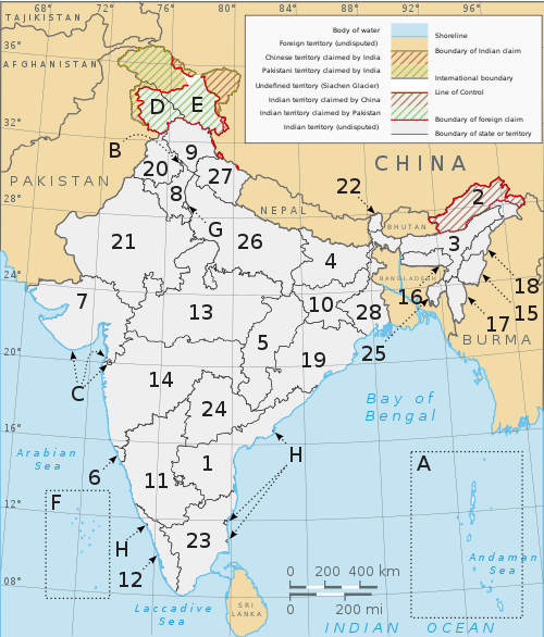
A clickable map of the 28 states and 8 union territories of India
States
| Number | State | Code | Estd. | Capital |
|---|---|---|---|---|
| 1 | Andhra Pradesh | AP | Hyderabad (de jure) Amaravati (administrative capital)(de facto) |
|
| 2 | Arunachal Pradesh | AR | Itanagar | |
| 3 | Assam | AS | Dispur | |
| 4 | Bihar | BR | Patna | |
| 5 | Chhattisgarh | CG | Naya Raipur | |
| 6 | Goa | GA | Panaji | |
| 7 | Gujarat | GJ | Gandhinagar | |
| 8 | Haryana | HR | Chandigarh (shared with Punjab, also a Union Territory) | |
| 9 | Himachal Pradesh | HP | Shimla (summer), Dharamshala (winter) | |
| 10 | Jharkhand | JH | Ranchi | |
| 11 | Karnataka | KA | Bangalore | |
| 12 | Kerala | KL | Thiruvananthapuram | |
| 13 | Madhya Pradesh | MP | Bhopal | |
| 14 | Maharashtra | MH | Mumbai (summer), Nagpur (winter) | |
| 15 | Manipur | MN | Imphal | |
| 16 | Meghalaya | ML | Shillong | |
| 17 | Mizoram | MZ | Aizawl | |
| 18 | Nagaland | NL | Kohima | |
| 19 | Odisha | OD | Bhubaneshwar | |
| 20 | Punjab | PB | Chandigarh (shared with Haryana, also a Union Territory) | |
| 21 | Rajasthan | RJ | Jaipur | |
| 22 | Sikkim | SK | Gangtok | |
| 23 | Tamil Nadu | TN | Chennai | |
| 24 | Telangana | TS | Hyderabad | |
| 25 | Tripura | TR | Agartala | |
| 26 | Uttar Pradesh | UP | Lucknow | |
| 27 | Uttarakhand | UT | Dehradun (winter), Gairsain (summer) | |
| 28 | West Bengal | WB | Kolkata |
Union territories
| Letter / number | Union territory | Code | Capital |
|---|---|---|---|
| A | Andaman and Nicobar Islands | AN | Port Blair |
| B | Chandigarh | CH | Chandigarh (also the capital of Haryana and Punjab) |
| C | Dadra and Nagar Haveli and Daman and Diu | DD | Daman |
| D | Jammu and Kashmir | JK | Srinagar (summer), Jammu (winter) |
| E | Ladakh | LA | Leh and Kargil |
| F | Lakshadweep | LD | Kavaratti |
| G | National Capital Territory of Delhi | DL | New Delhi |
| H | Puducherry | PY | Pondicherry |
Autonomous administrative divisions
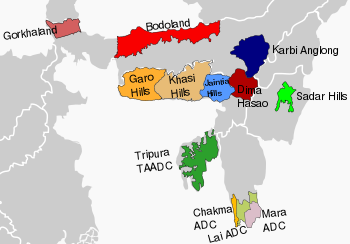
Autonomous areas in North East India
The Sixth Schedule of the Constitution of India allows for the formation of autonomous administrative divisions which have been given autonomy within their respective states. Most of these autonomous areas are located in North East India.
Autonomous district councils operating under the Sixth Schedule of the Constitution of India are shown like this.
| State/Union Territory | Autonomous Council | Headquarters | Districts / Subdivisions |
|---|---|---|---|
| Assam | Bodoland | Kokrajhar | Baksa, Chirang, Kokrajhar, Udalguri |
| Deori | Narayanpur | Lakhimpur | |
| North Cachar Hills | Haflong | Dima Hasao | |
| Karbi Anglong | Diphu | Karbi Anglong, West Karbi Anglong | |
| Mising | Dhemaji | Dhemaji | |
| Rabha Hasong | Dudhnoi | Kamrup Rural, Goalpara | |
| Sonowal Kachari | Dibrugarh | ||
| Thengal Kachari | Titabar | ||
| Tiwa | Morigaon | ||
| Ladakh | Kargil | Kargil | Kargil |
| Leh | Leh | Leh | |
| Manipur | Chandel | Chandel | |
| Churachandpur | Churachandpur | ||
| Sadar Hills | Kangpokpi | Saikul, Saitu and Sadar Hills West subdivisions of Kangpokpi district | |
| Senapati | Senapati | ||
| Tamenglong | Tamenglong | ||
| Ukhul | Ukhrul | ||
| Meghalaya | Garo Hills | Tura | East Garo Hills, West Garo Hills, South Garo Hills, North Garo Hills and South West Garo Hills |
| Jaintia Hills | Jowai | East Jaintia Hills, West Jaintia Hills | |
| Khasi Hills | Shillong | West Khasi Hills, East Khasi Hills and Ri Bhoi | |
| Mizoram | Chakma | Kamalanagar | Tuichawng subdivision |
| Lai | Lawngtlai | Lawngtlai subdivision, Sangau subdivision | |
| Mara | Siaha | Siaha subdivision, Tipa subdivision | |
| Tripura | Tripura Tribal Areas | Khumulwng | |
| West Bengal | Gorkhaland | Darjeeling | Darjeeling, Kurseong and Mirik subdivisions of Darjeeling district, Kalimpong district |
Divisions
Many of the Indian states are subdivided into divisions which have official administrative governmental status and each division is headed by senior IAS officer called Divisional Commissioner. Currently, superdistrict administrative divisions exist in 18 of the 28 states and 3 of the 8 union territories. The states of Gujarat, Kerala, Tamil Nadu, Andhra Pradesh, Telangana, Sikkim, Manipur, Tripura, Mizoram and Goa, and the union territories of Dadra and Nagar Haveli and Daman and Diu, Puducherry, Chandigarh, Lakshadweep and the Andaman and Nicobar Islands do not have divisions. Currently, there are a total of 102 divisions in India.
| State/Union Territory | Division | Headquarter District | Districts |
|---|---|---|---|
| Arunachal Pradesh | East | Namsai | Lohit, Anjaw, Tirap, Changlang, Lower Dibang Valley, Dibang Valley, East Siang, Upper Siang, Longding, Namsai, Siang |
| West | Lower Subansiri | Tawang, West Kameng, East Kameng, Papum Pare, Lower Subansiri, Kurung Kumey, Kra Daadi, Upper Subansiri, West Siang, Lower Siang and Itanagar Capital Complex | |
| Assam | Upper Assam Division | Jorhat | Charaideo, Dhemaji, Dibrugarh, Golaghat, Jorhat, Lakhimpur, Majuli, Sivasagar, and Tinsukia |
| Lower Assam Division | Guwahati | Baksa, Barpeta, Bongaigaon, Chirang, Dhubri, Goalpara, Nalbari, Kamrup Metropolitan, Kamrup Rural, Kokrajhar, and South Salmara-Mankachar | |
| North Assam Division | Tezpur | Biswanath, Darrang, Sonitpur, and Udalguri | |
| Central Assam Division | Nagaon | Dima Hasao, Hojai, East Karbi Anglong, West Karbi Anglong, Morigaon, and Nagaon | |
| Barak Valley | Silchar | Cachar, Hailakandi, and Karimganj | |
| Bihar | Patna division | Patna | Patna, Nalanda, Bhojpur, Rohtas, Buxar and Kaimur |
| Tirhut division | Muzaffarpur | West Champaran, East Champaran, Muzaffarpur, Sitamarhi, Sheohar and Vaishali | |
| Saran division | Chhapra | Saran, Siwan and Gopalganj | |
| Darbhanga division | Darbhanga | Darbhanga, Madhubani and Samastipur | |
| Kosi division | Saharsa | Saharsa, Madhepura and Supaul | |
| Purnia division | Purnia | Purnia, Katihar, Araria and Kishanganj | |
| Bhagalpur division | Bhagalpur | Bhagalpur and Banka | |
| Munger division | Munger | Munger, Jamui, Khagaria, Lakhisarai, Begusarai and Sheikhpura | |
| Magadh division | Gaya | Gaya, Nawada, Aurangabad, Jehanabad and Arwal | |
| Chhattisgarh | Surguja | Surguja | Koriya, Balrampur-Ramanujganj, Surajpur, Jashpur and Surguja |
| Bilaspur | Bilaspur | Bilaspur, Mungeli, Korba, Janjgir-Champa, Raigarh and Gourella Pendra Marwahi | |
| Durg | Durg | Kabirdham (Kawardha), Bemetara, Durg, Balod and Rajnandgaon | |
| Raipur | Raipur | Mahasamund, Baloda Bazar, Gariaband, Raipur and Dhamtari | |
| Bastar division | Bastar | Kanker (Uttar Bastar), Narayanpur, Kondagaon, Bastar, Dantewada (Dakshin Bastar), Bijapur and Sukma | |
| Haryana | Hisar division | Hisar | Fatehabad, Jind, Hisar and Sirsa |
| Gurgaon division | Gurugram | Gurugram, Mahendragarh and Rewari | |
| Ambala division | Ambala | Ambala, Kurukshetra, Panchkula and Yamuna Nagar | |
| Faridabad division | Faridabad | Faridabad, Palwal and Nuh | |
| Rohtak division | Rohtak | Jhajjar, Charkhi Dadri, Rohtak, Sonipat and Bhiwani | |
| Karnal division | Karnal | Karnal, Panipat and Kaithal | |
| Himachal Pradesh | Kangra | Kangra | Chamba, Kangra and Una |
| Mandi | Mandi | Bilaspur, Hamirpur, Kullu, Lahaul and Spiti and Mandi | |
| Shimla | Shimla | Kinnaur, Shimla, Sirmaur and Solan | |
| Jharkhand | Palamu division | Palamu | Garhwa, Latehar and Palamu |
| North Chotanagpur division | Hazaribagh | Bokaro, Chatra, Dhanbad, Giridih, Hazaribagh, Koderma and Ramgarh | |
| South Chotanagpur division | Ranchi | Gumla, Khunti, Lohardaga, Ranchi and Simdega | |
| Kolhan division | West Singhbhum | East Singhbhum, Seraikela Kharsawan district, and West Singhbhum | |
| Santhal Pargana division | Dumka | Godda, Deoghar, Dumka, Jamtara, Sahibganj and Pakur | |
| Karnataka | Bangalore division | Bangalore | Bangalore Urban, Bangalore Rural, Ramanagara, Chikkaballapur, Chitradurga, Davanagere, Kolar, Shivamogga and Tumakuru |
| Mysore division | Mysuru | Chamarajanagar, Chikkamagaluru, Udupi, Dakshina Kannada, Hassan, Kodagu, Mandya and Mysuru | |
| Belgaum division |